WKN Weer, Klimaat en Natuurrampen
Lees alles over het onstuimige weer op onze planeet, volg orkanen en tornado's, zie hoe vulkanen uitbarsten en hoe Moeder Aarde beeft bij een aardbeving. Alles over de verwoestende kracht van onze planeet en tal van andere natuurverschijnselen.


Welkom! Hier alweer het volgende deel in de reeks Hurricane Season! Alle informatie over het ontstaan van nieuwe orkanen in 2010 vind je hier. En natuurlijk volgen we ze allemaal op de voet! Voor zowel Atlantische, Indische als Pacifische stormen kan je hier terecht
Algemene Info
Met de term 'Hurricane Season' bedoelden we in eerste instantie de periode van 1 juni tot 30 november. Deze periode wordt in de Atlantische Oceaan en de Golf van Mexico gezien als het orkaanseizoen. Echter komen deze gewelddadige stormen overal in de wereld voor en met name in Azië zorgen ze jaarlijks voor duizenden slachtoffers en tienduizenden daklozen. Echter horen we vaak erg weinig over de stormen in Azië en juist meer over die in de VS.
In de laatste jaren zijn Tropische Stormen meer en meer in de media gekomen. Het lijkt ook alsof ze meer en meer slachtoffers maken. Een documentaire over Hurricane Andrew uit 1992, heeft diepe indruk gemaakt en ook zullen kenners orkanen Floyd, Gilbert, Stan en Ivan zich zeker nog herinneren. De catastrofe die "Katrina" met zich meebracht ging de hele wereld over. En dan praten we eigenlijk alleen over de Atlantische stormen en lijken we te vergeten dat er in 2007 meer dan 4000 doden vielen in Bangladesh door orkaan Sidr en orkaan Nargis zorgde voor 80.000 doden in Myanmar alleen al.
Hoewel het Atlantische seizoen pas officieel in juni begint zijn er op andere plekken in de wereld zeker meer orkanen te vinden in de komende maanden. We zullen ook deze dus zeker gaan bespreken. Waarschijnlijk zal de kern van de discussie en de posts gaan over de periode 1 juni tot 30 november. T.z.t. zal er ook wel een NWS-topic worden geopend als een orkaan ook uitgebreid in het nieuws komt.
Orkanen: Hoe ontstaan ze eigenlijk?
Op de site van Wikipedia kan je in het Nederlands nalezen hoe ze ontstaan en wat de belangrijkste energiebron is voor hun verwoestende kracht: het warme zeewater

Ook de BBC heeft er een interessante en leuke animatie over gemaakt.
Ook wordt er op LiveScience in het engels prima uitgelegd hoe ze ontstaan en zich ontwikkelen
Indeling, Kracht en Stormvloed
De stormen worden ingedeeld op 'categorie'. Vaak zijn het eerst tropische stormen" (Tropical Depression, Tropical Storms), die overgaan tot Orkaanstatus (Hurricanes/Tyfoons) Ze worden ingedeeld op windsnelheden via de Saffir-Simpson Schaal.
Door de enorme windkracht van een orkaan wordt het zeewater opgestuwd. Dit zeewater wordt als het ware vooruit geblazen, voor de storm uit. Hoe zwaarder de orkaan des te meer zeewater vooruit wordt geduwd. De stormvloed wordt dan ook gemeten bovenop de reguliere golfslag. Je kan het enigszins vergelijken met een muur van water (tsunami) die vooruit wordt geduwd.
Tropische Depressie: windsnelheden van 38 tot 61 km/u
Tropische Storm: windsnelheden van 62 tot 118 km/u
Orkaan 1e categorie: windsnelheden van 119 tot 153 km/u en een stormvloed van 1 tot 1,5 meter boven normaal
Orkaan 2e categorie: windsnelheden van 154 tot 177 km/u en een stormvloed van 1,5 tot 2,5 meter boven normaal
Orkaan 3e categorie: windsnelhden van 178 tot 209 km/u en een stormvloed van 2,5 tot 3,7 meter boven normaal
Orkaan 4e categorie: windsnelheden van 210-249 km/u en een stormvloed van 3,8 tot 5,5 meter boven normaal
Orkaan 5e categorie: windsnelheden > 250 km/u en een stormvloed van meer dan 5,5 meter boven normaal
TIP: Interactief (film)overzicht van de krachten van orkanen n.a.v. de schaal van Simpson
Waarom hebben orkanen namen?
De Tropische Depressies worden overal ter wereld in de gaten gehouden en zodra de depressies uitgroeien tot orkaan of cycloon, wordt er een naam aan de storm gegeven. Sinds 1950 krijgen ze namen op alfabetische volgorde (met uitzondering van de letters Q, U, X, Y en Z). Mocht een orkaan vernietigend hebben huisgehouden zoals Floyd, Gilbert en bijv. Katrina, dan zal die naam worden vervangen. Soms komt het ook voor dat alle letters van het alfabet gebruikt zijn in één seizoen (zoals 2005), dan zal een volgende storm Alpha gaan heten, gevolgd door Beta etc etc. Voor het orkanenseizoen 2010 zijn de namen als volgt:
Atlantische Stormen 2010
Alex, Bonnie, Colin, Danielle, Earl, Fiona, Gaston, Hermine, Igor, Julia, Karl, Lisa, Matthew, Nicole, Otto, Paula, Richard, Shary, Tomas, Virginie, Walter.
In het Noordoosten van de Pacific ontstaan ook orkanen. Deze zorgen meestal voor weinig schade aan de Amerikaanse/Mexicaanse westkust.
Oost Pacifische Stormen 2010
Agatha, Blas, Celia, Darby, Estelle, Frank, Georgette, Howard, Isis, Javier, Kay, Lester, Madeline, Newton, Orlene, Paine, Roslyn, Seymour, Tina, Virgil, Winifred, Xavier, Yolanda, Zeke
Verder zijn er dan nog de stormen in het Noorden, Zuiden en Westen van de Pacific. Daar worden ze tyfoons en/of cyclonen genoemd. Vooral de stormen in het Noord/Westen komen vaak in het nieuws omdat ze Japan, de Filippijnen, Taiwan en China vaak teisteren, maar ook geheel Zuid Oost Azië kunnen treffen. Meer informatie over de namen van orkanen vind je hier.
Leuk hoor allemaal, maar wanneer zijn die orkaanseizoenen nou precies?
ATLANTISCHE OCEAAN: 1 juni t/m 30 november
NOORD OOST PACIFIC:Begin mei t/m begin november, met piek in augustus/september
NOORD WEST PACIFIC: Begin juli t/m eind november, maar eigenlijk hele jaar door activiteit.
NOORD INDISCHE OCEAAN: april t/m december met pieken in mei en november
ZUID INDISCHE + WEST AUSTRALISCHE OCEAAN: oktober t/m mei met pieken in februari en april
ZUID WEST PACIFIC + OOST AUSTRALISCHE OCEAAN: oktober tot eind april met piek in februari.
Over het algemeen is Mei de rustigste maand en September de zwaarste.
En? Zijn er al verwachtingen en/of voorspellingen voor 2010?
Begin december kwamen de eerste voorspellingen voor 2010 naar buiten. Ze verwachten een boven gemiddeld seizoen. 50 jaar orkaangeschiedenis heeft een zogenaamd gemiddeld orkaanseizoen gecreëerd. 9,6 stormen met naam, 5,9 groeit uit tot orkaan en 2,3 worden superorkanen (cat 4 of 5) Volgens de decemberverwachting is de verwachting dat er in 2010 elf tot zestien ‘naam-stormen’ zullen ontstaan in de Atlantische Oceaan. Zes tot acht groeien uit tot orkaan en drie tot vijf daarvan zullen superorkanen worden. Deze voorspelling kan je hier of hier nog eens nalezen.
Oude Delen
2004 - Deel 1 en Deel 2
2005 - Deel 1 en Deel 2
2006 - Deel 1 en Deel 2
2007 - Deel 1, Deel 2, Deel 3 en Deel 4
2008 - Deel 1 en Deel 2
2009 - Deel 1 en Deel 2
Enkele Links
1. National Hurricane Centre
2. Carribean Storm Network
3. Hurricanezone
4. Hurricane Track
5. Website met satelietbeelden van de Caribbean en de rest van Amerika
6. Intellicast: Geavanceerde satellietfoto's en gifs van aktuele stormen
7. Tropical Weather Underground
8. Tropical Storm Risico's van dit moment
9. Wikipedia Hurricanes/Tyfonen in het algemeen
10. Alle stormen ter wereld van de laatste jaren in overzicht
11. The StormTrack
12. Orkanensite in de Filipijnen
13. Atlantische Orkanensite
14. Actuele orkanen in Australië en De orkaanindeling in Australië
15. Tropische weersite omgeving Australië
16. Mooie site over Orkanen aan de VS kusten
17. Website van NASA over Hurricanes
Opmerkelijke Wikipedia-Links
-- Hurricane Katrina 2005
-- Cyclone Nargis 2008
-- Hurricane Season 2009 - Wikipedia
-- Hurricane Season 2008 - Wikipedia
-- Hurricane Season 2007 - Wikipedia
-- Hurricane Season 2006 - Wikipedia
-- Hurricane Season 2005 - Wikipedia
-- Hurricane Season 2004 - Wikipedia
Actuele Weerradar in Golf van Mexico

Actuele Water temperatuur.
=====================
Heb je informatie over orkanen of wil je gewoon alle orkanen van 2010 volgen, volg dan dit topic
[ Bericht 0% gewijzigd door Frutsel op 20-05-2010 14:14:54 ]


Mooie OP 
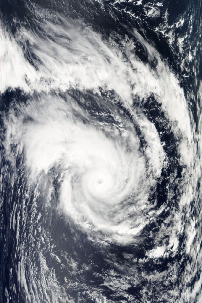
Tropical Cyclone EDZANI is de enige storm momenteel. Nu een categorie3, maar hard op weg naar een categorie 4.
Tropical Cyclone EDZANI is de enige storm momenteel. Nu een categorie3, maar hard op weg naar een categorie 4.


Hier nog een leuk Sat-beeld:
Origineel: http://rapidfire.sci.gsfc(...)10007083000.250m.jpg
[ Bericht 15% gewijzigd door Frutsel op 11-01-2010 14:52:46 ]
Origineel: http://rapidfire.sci.gsfc(...)10007083000.250m.jpg
[ Bericht 15% gewijzigd door Frutsel op 11-01-2010 14:52:46 ]

Als er warm water is wil dat nog niks zeggenquote:Op dinsdag 12 januari 2010 10:14 schreef Gummibeer79 het volgende:
Dan wordt dan wellicht een interessant seizoen!
zo lang er weer veel windshear is zoals de afgelopen jaren dan wordt het niks
Wat is windshear?quote:Op dinsdag 12 januari 2010 17:51 schreef SoldMayor het volgende:
[..]
Als er warm water is wil dat nog niks zeggen
zo lang er weer veel windshear is zoals de afgelopen jaren dan wordt het niks

Iets moois. Vooral in combinatie met leuk wat CAPEquote:
Nog 2 Sat-beelden van Edzani: 130110 en 140110:


quote:Tropical Cyclone Magda is expected to intensify further as it approaches the Kimberley coast, reaching category three intensity tonight and possibly reaching category four intensity prior to impacting the coast on Friday. There is the risk of very destructive winds with gusts to 250 kilometres per hour near the cyclone centre on Friday, by which time the cyclone should be close to the coast, between Kuri Bay and Cape Leveque.
Gales with gusts to 100 kilometres per hour may develop in coastal areas between Mitchell Plateau and Cape Leveque tonight as the cyclone approaches. Gales may extend to Derby during Friday and may reach as far south as Bidyadanga including Broome on Saturday.
Heavy rainfall, with falls in excess of 100mm, is expected near the cyclone track in the west Kimberley on Friday and Saturday.
Tides on Friday will be higher than expected between Mitchell Plateau and Cape Leveque with flooding of low lying areas possible.


Orkanen in de 21e eeuw: bijna dubbel zoveel zware
De sterkste Atlantische orkanen kunnen bijna verdubbelen in frequentie aan het einde van de eeuw als de aarde opwarmt, zo luidt een rapport dat vrijdag verscheen in het tijdschrift Science.
Bij de nieuwe studie is gebruik gemaakt van de meest uitgebreide computermodellering van orkanen tot dusver. De resultaten geven aan dat, het totale aantal van de Atlantische cyclonen naar bijna 30 procent minder zou kunnen dalen in de komende 80 jaar. Echter, het aantal van categorie 4 en 5 orkanen, de sterkste en meest destructieve stormen, kan stijgen met 80 procent.
Het eindresultaat kan een 30 procent stijging van de materiële schade zijn, aldus de co-auteur van deze studie Tom Knutson, een klimaatwetenschapper bij de National Oceanic and Atmospheric Administration (NOAA), in een interview.
"Er zullen minder stormen zijn , maar meer van deze intensere stormen, en dat geeft toename van de potentiële schade, 'zei hij. Hij voegde eraan toe dat de 80 procent verhoging neerkomt op ongeveer een verdubbeling in de komende eeuw.
Het gebied ten noordoosten van Cuba en ten oosten van Florida kan de grootste piek in het voorkomen en van de intensiteit van de orkanen zien, zo is in de studie gevonden.
Het onderzoek kan consequenties hebben voor de toeristische industrie van Florida en de Bahama’s waar miljarden in omgaan, en voor de oliewinningen in de Golf van Mexico.
Orkanen die in categorie 4 of 5 op de schaal van 5 van Saffir-Simpson vallen hebben een windsnelheid van ten minste ca. 210 km/uur, en zullen naar verwachting toenemen in frequentie in de komende decennia. Ter vergelijking, de orkaan Katrina, die New Orleans trof in 2005 - waardoor 1833 mensen het leven verloren en er 80 miljard dollar schade ontstond - was slechts een cycloon van categorie 3 toen hij aan land ging.
Bij het uitvoeren van hun studie, zijn onderzoekers uitgegaan van een gemiddelde stijging van de zeeoppervlaktetemperatuur van de tropen van 1,7 graden Celsius, dit als gevolg van opwarming van de aarde in de komende 80 jaar, zegt Knutson. Dergelijke warmere wateren zullen meer leiden tot de vorming van orkanen.
Het totale aantal orkanen zou dalen, zegt Knutson, omdat de omstandigheden in het gebied waar de stormen meestal beginnen naar verwachting minder gunstig zullen zijn voor cycloonvorming.
Echter, die vorm doen en verhuizen van de regio vindt omstandigheden meer kans om de toegevoegde intensiteit stimuleren, zodat de sterkste orkanen meer zullen frequenter worden, legde hij uit.
De belangrijkste stijging in sterkere cyclonen werd gevonden ten noorden van 20 graden, ten noorden van de breedtegraad die loopt ten zuiden van Cuba via het schiereiland Yucatan in Mexico, aldus Morris Bender van NOAA, hoofdauteur van de studie.
Volgens de studie, kan het gebied ten oosten van Florida, met inbegrip van de Bahama's, worden getroffen met drie categorie 4 en 5 cyclonen per decennium.
De toename van de frequentie van sterkere stormen kan bedrijven zoals Blackstone Group LP's Hilton Hotels Corp en cruise operator Carnival Corp, beïnvloeden.
Andere industrie kan ook worden beïnvloed, met inbegrip van olieplatforms en installaties in de Golf van Mexico, geëxploiteerd door bedrijven als BP, Exxon Mobil en Chevron.
Bron: Redorbit.com
vwk
Olga is weer tot leven gekomen boven Australie.
Verderop is een tweede storm bezig om orkaankracht te ontwikkelen.
Verderop is een tweede storm bezig om orkaankracht te ontwikkelen.


quote:Olga has drenched Queensland for days. Several more days of heavy rain is expected. Tropical rainstorm Olga will stall over southeastern Queensland. Nearly 20 inches of rain has already affected northern Queensland over the past week.
Across eastern and southern Queensland, 5-10 inches of rain, locally more than 15 inches, is expected. This includes Queensland's biggest city, Brisbane.
Parts of southern Queensland have suffered drought conditions as of late. So, the rain is not all bad news. Southern Queensland is a major agricultural area, where this rain will be welcome. Despite drought conditions, the rain will be heavy enough for localized flooding.
Rain from Tropical Rainstorm Olga will last through the middle of next week.


quote:orkaan Oli teistert Tahiti
Een zware wervelstorm is gisteren en vandaag over het vakantieparadijs Tahiti geraasd. De storm heeft op de archipel in de Stille Zuidzee aanzienlijke schade aangericht, ook in de toeristische resorts. Verschillende mensen zijn om het leven gekomen. Ruim 4.000 mensen moesten voor cycloon 'Oli in veiligheid gebracht worden, aldus de autoriteiten van Frans-Polynesië.
Bewoners krijgen een rij- en uitgaansverbod, zo berichtte de internetsite '20minutes'. Op de eilanden onder de wind werden een 300-tal woningen vernield of door de zee overspoeld. De golven bereikten een hoogte van meer dan zes meter. Vandaag draaide 'Oli' af naar het zuiden en won daarbij nog aan kracht.

Rene gaat richting de Tonga eilanden.quote:Op woensdag 10 februari 2010 16:09 schreef Frutsel het volgende:
Gaat Pat ook over Frans Polynesie? Of welk gebied ligt daar?
Cycloon Pat is over het kleine Polynesisch eiland Aitutaki geraasd en heeft tot 90 procent van alle woningen vernield.
Op het eiland, dat tot de Cookeilanden behoort, wonen bijna 2.000 mensen. Urenlang ging cycloon 'Pat' met windsnelheden van meer dan 100 kilometer per uur te keer op het eiland. Bomen knapten af, blokkeerden de wegen en beschadigden elektriciteitsleidingen.
Naar verluidt liepen de hotelresorts op Aitutaki niet al teveel schade op. Twee mensen werden door rondvliegende brokstukken gewond. Een ooggetuige verklaarde op Radio New Zealand dat een 30-tal toeristen en 30 inheemsen in een kerk in veiligheid werden gebracht.
Ook voor het hoofdeiland van de Cookeilanden, Rarotonga, riep de premier noodtoestand uit. Scholen en overheidsgebouwen werden uit voorzorg gesloten. Tot de Cookeilanden behoren 15 eilanden. Ze liggen ten noorden van Nieuw-Zeeland.

Rene trekt over de Samoa en Tonga eilanden heen.
quote:Tropical Cyclone RENE-10 of Saffir-Simpson Category 2 affected 27 thousand people with winds above 39mph (63 km/h) and 19 thousand people with hurricane wind strengths (74mph or 119 km/h). In addition, few people are living in coastal areas below 5m and can therefore be affected by storm surge

quote:NOAA komt met een vernieuwde Saffir-Simpson Schaal
NOÄA gaat dit jaar een vernieuwde Saffier - Simpson schaal gebruiken om hurricanes in te delen in categorieën. De vernieuwde schaal krijgt als officiële titel de " Saffir-Simpson Hurricane Wind Scale "
Het verschil met de oude indeling is dat stormvloed uit de schaal is verdwenen. De reden hiervoor is dat de stormsurge en de gevolgen daarvan niet alleen bepaald worden door de intensiteit van de orkaan.
Zo is de stormvloed ook afhankelijk van de grote van het systeem en regionale eigenschappen van het gebied waar de orkaan over heen trekt. Het gevolg was dat een orkaan van een lagere categorie een grotere stormvloed kan hebben dan orkanen van een hogere categorie. Een bekend voorbeeld was hurricane Ike (categorie 2) die een stormvloed had van rond de 3 meter terwijl categorie 4 hurricane Charley nog geen stormvloed had van 1,5 meter. De reden dat Ike een grotere stormvloed had kwam o.a door het feit dat het zo'n groot systeem was.

Dit hangt voor de kust van Brazilie.

quote:A rare weather event is underway in the South Atlantic Ocean, where the basin's 7th recorded tropical or subtropical cyclone of all-time has formed. An area of disturbed weather (Invest 90Q) off the coast of Brazil, near 30S 48W, attained a well-defined surface circulation, top wind speeds of tropical depression strength (35 mph), a warm core in the bottom portion of the atmosphere, and a cold core aloft last night. If this storm had been in the North Atlantic, there is a good chance it would have been named Subtropical Depression One. However, tropical and subtropical storms are so rare in the South Atlantic that there is no official naming of depressions or storms done. The cyclone had top winds of at least 35 mph as seen on an ASCAT pass at 7:02 am EST this morning (Figure 2), and satellite estimates of the storm's intensity topped out at 40 mph (minimum subtropical storms strength) last night. This morning, the satellite estimates are showing that the system has weakened to a 35 mph tropical depression. There is some moderate wind shear interfering with development, and sea surface temperatures are about 25°C, which is about 1°C below what is typically needed to support a tropical storm. The storm is headed eastward out to sea, and is not a threat to any land areas. The models show the storm will lose its tropical characteristics and get absorbed by a frontal system by Saturday.

2010 Hurricane Season will be More Active
quote:AccuWeather.com Hurricane Center meteorologists, led by Chief Long-Range Meteorologist and Hurricane Forecaster Joe Bastardi, have released their early hurricane season forecast for the Atlantic Basin for 2010.
The forecast is calling for a much more active 2010 season with above-normal threats on the U.S. coastline.
"This year has the chance to be an extreme season," said Bastardi. "It is certainly much more like 2008 than 2009 as far as the overall threat to the United States' East and Gulf coasts."
Bastardi is forecasting seven landfalls. Five will be hurricanes and two or three of the hurricanes will be major landfalls for the U.S.
He is calling for 16 to 18 tropical storms in total, 15 of which would be in the western Atlantic or Gulf of Mexico and therefore a threat to land.
In a typical season, there are about 11 named storms of which two to three impact the coast of the United States.
bron
"Kans op extreme orkanen is erg groot dit jaar"
Het orkaanseizoen zal dit jaar vroeg van start gaan en bovengemiddeld zijn. Dat verwachten de meteorologen van AccuWeather, onder leiding van Joe Bastardi, die zich bezig houdt met lange termijnvoorspellingen en orkanen. "Dit jaar is de kans op een extreem seizoen erg groot. Er zullen zeker veel meer orkanen zijn dan in 2008 en 2009 en er zal ook dreiging zijn voor de kust van Amerika", aldus Bastardi.
Bastardi voorspelt zeven orkanen die aan land gaan komen. Vijf van categorie één of twee en twee orkanen van categorie drie tot en met vijf. Ook voorspelt hij 16 tot 18 tropische stormen in totaal, waarvan er 15 zullen voorkomen in de westelijke Atlantische Oceaan of de Golf van Mexico en dus een bedreiging voor het land vormen. In een normaal seizoen zijn er ongeveer 11 stormen, waarvan twee á drie de kust van de Verenigde Staten bereiken.
Er zijn een aantal factoren waarop Bastardi dit baseert:
- De snelle afzwakking El Niño.
- Warmere oceaan temperaturen in de tropische broeikassen in vergelijking met vorig jaar. Weet dat tropische stormen hun energie uit warm water onttrekken.
- Verzwakking van de passaatwinden, die de hoeveelheid droge lucht in de tropen van Afrika verminderen.
- Hogere luchtvochtigheid, die extra opwaartse beweging brengt in de lucht. Dat is gunstig voor ontwikkeling van een tropische storm.
Geschiedenis
Bastardi heeft een aantal orkaanseizoenen (1964, 1995 en 1998) uit het verleden vergeleken met het komende seizoen. Alle waren ze van grote invloed voor de Amerikaanse kust. In 1964 sloeg de orkaan Cleo toe in het zuidoosten van Florida, in de buurt van Miami, als een categorie 2 storm en doodde 217 mensen. In 1995 kwam orkaan Opal aan land in Pensacola (Florida) als een categorie 3 storm. Die storm veroorzaakte een een schadepost van ongeveer 3 miljard dollar. In 1998 trof orkaan Bonnie Wilmington (North Carolina), een categorie 2 storm en later nam de orkaan toe tot categorie 3. Bonnie veroorzaakte aanzienlijke schade aan gewassen en in totaal was er ongeveer voor 1 miljard dollar schade.
Zoals Bastardi vorig jaar had voorspeld, lag het Atlantisch orkaanseizoen (2009) ver onder het gemiddelde met elf tropische depressies. Slechts negen van deze werden tropische stormen. Dat was het laagste aantal sinds 1997. Het Atlantisch orkaanseizoen begint officieel op 1 juni en gaat door tot 30 november. Deze data werden geselecteerd omdat 97 procent van de orkaanactiviteit voorkomt gedurende deze periode van zes maanden. (onweer-online.nl)
hln
Het blijven voorspellingen, men heeft er wel vaker naast gezeten
* I intend to live forever, so far so good! *

Cat 5 wordt het zelfs. Ik ben benieuwd hoe dicht deze bij Australie gaat komen.quote:
[ Bericht 5% gewijzigd door #ANONIEM op 13-03-2010 16:12:12 ]
TOMAS (rechts) nu een cat 1
ULUI (links) nu een cat 3
[ Bericht 0% gewijzigd door #ANONIEM op 13-03-2010 19:56:26 ]
ULUI (links) nu een cat 3

[ Bericht 0% gewijzigd door #ANONIEM op 13-03-2010 19:56:26 ]
Tropische storm eist 14 doden in Madagaskar
hlnquote:Drie dagen lang teisterde de tropische storm 'Hubert' het eiland Madagaskar. De balans is zwaar: 14 doden en meer dan 27.000 mensen zijn dakloos. Duizenden huizen raakten beschadigd en liepen onder water.
Moeilijke hulpverlening
Volgens de nationale tv-zender is de regio rond de stad Mananjary, in het zuiden van het land, het zwaarst getroffen. Een vierde van de stad zou onder water staan, zo luidt het bij het National Office for Disaster and Risk Management (BNGRC). Ook de stroom- en watervoorziening zijn onderbroken. Doordat vele straten niet toegankelijk zijn, konden er nog geen hulpgoederen naar Mananjary gebracht worden. (dpa/eb)


Cat.4 Orkaan Tomas teistert Fiji Eilanden
We zullen eens wat vaker topics apart gaan openen voor orkanen of bijv aardbevingen. Eens kijken of we dan het aantal views kunnen opkrikken. De centrale topics kunnen er wat mij betreft gewoon tussendoor blijven lopen.
[ Bericht 78% gewijzigd door Frutsel op 15-03-2010 11:14:57 ]
We zullen eens wat vaker topics apart gaan openen voor orkanen of bijv aardbevingen. Eens kijken of we dan het aantal views kunnen opkrikken. De centrale topics kunnen er wat mij betreft gewoon tussendoor blijven lopen.
[ Bericht 78% gewijzigd door Frutsel op 15-03-2010 11:14:57 ]
Lekker. Mijn zoons zijn zondagochtend geland op Nadi en ik heb nog niets gehoord. Nu weet ik waarom niet.quote:Op maandag 15 maart 2010 11:05 schreef Frutsel het volgende:
Cat.4 Orkaan Tomas teistert Fiji Eilanden
We zullen eens wat vaker topics apart gaan openen voor orkanen of bijv aardbevingen. Eens kijken of we dan het aantal views kunnen opkrikken. De centrale topics kunnen er wat mij betreft gewoon tussendoor blijven lopen.
woef

Ului lijkt toch richting Australie te gaan. Er zijn door wel een aantal grote steden.
Mackay, Gladstone, Brisbane.
Mackay, Gladstone, Brisbane.

Gifje van ULUI van maandag t/m maandag.
Volgens GFS zou deze orkaan ergens tussen Brisbane en Gladstone tercht komen, daar even blijven rondtollen en vervolgens weer de zee optrekken.
[ Bericht 16% gewijzigd door #ANONIEM op 15-03-2010 20:10:49 ]
Volgens GFS zou deze orkaan ergens tussen Brisbane en Gladstone tercht komen, daar even blijven rondtollen en vervolgens weer de zee optrekken.

[ Bericht 16% gewijzigd door #ANONIEM op 15-03-2010 20:10:49 ]
Queensland holds its breath as Cyclone Ului tracks parallel with coast
bronquote:WEATHER Bureau forecasters predict Cyclone Ului will turn south today, tracking parallel with the Queensland coast.
But the US Joint Typhoon Warning Centre has the cyclone easing and veering towards the coast in an area between Fraser Island and Airlie Beach on Friday.
Ului was situated south of the Solomon Islands yesterday, 1400km northeast of Mackay and moving west-southwest at 7km/h. That is about half its speed of the previous day.
Forecaster Geoff Doueal said it was common for models to disagree.
"There's not much (weather conditions) steering this at the moment, so it's a wait and see," he said.
Ului drifted slowly west yesterday, but its longer-term track remained uncertain.
quote:Tropische storm Madagaskar eist 28 doden
Op het eiland Madagaskar is de dodentol na de tropische storm Hubert van vorige week opgelopen tot 28. De meeste slachtoffers vielen nadat een aardverschuiving verschillende huizen vernielde in het district Mananjary, in het zuiden van het land. Dat hebben de lokale media gemeld.
In Mananjary vielen acht doden. Een vierde van de regio stond onder water en de stroom- en watervoorziening waren onderbroken.
De storm maakte meer dan 20.000 mensen dakloos, zo meldt het National Office for Disaster and Risk Management
Vrij vroeg in het seizoen maar nummer TWO is er al in W.Pacific...
belooft nog wat vorig jaar was maar telleurstellend
belooft nog wat

Nou de W.Pacific heeft altijd zware stormen ( cat.5 ) maar vorig viel dat wel mee...
Tsjaa daar op de philipijnen ging het wel mis maja
Tsjaa daar op de philipijnen ging het wel mis maja

Euh?
Dit beloofd niet veel goeds Nu al de temperaturen die normaliter in Juni of Juli voorkomen?
Voor je het weet heb je in April de eerste orkaan
quote:Sea surface temperature anomalies in the Atlantic are now getting ridiculous, seriously! A huge area is now 2 degrees Celsius above normal but even more concerning is the vast area that is fully 1 degree+ Celsius above normal. To put it in perspective, these temperatures are already where we would expect to see them in... June or July.
Dit beloofd niet veel goeds
Voor je het weet heb je in April de eerste orkaan

Ter info, bron nu.nl
AMSTERDAM – Het komende orkaanseizoen zal erg actief worden. Dit meldt het KNMI aan de hand van verwachtingen van klimaatonderzoekers. Zij baseren zich op de temperatuur van het zeewater.
Zo zou het zeewater op dit moment zeer warm zijn in het gebied waar de meeste orkanen ontstaan.
De verwachting is volgens het KNMI dat het water zeker de eerste maanden van het orkaanseizoen nog steeds warmer zal zijn dan gemiddeld. Boven warm water ontstaan meer orkanen.
El Niño en La Niña
Het gebied van de Atlantische Oceaan moet daarom rekenen op een zeer actief orkaanseizoen. Ook El Niño en La Niña kunnen hierop van invloed zijn. El Niño en La Niña zijn benamingen voor een afwijking van de zeewatertemperatuur in de Stille Oceaan nabij de evenaar.
De kans is volgens de onderzoekers groot dat de El Niño van de afgelopen periode na de zomer zal omslaan in een La Niña, waarbij het zeewater veel kouder is. Deze verandering heeft het ontstaan van tropische stormen en orkanen tot gevolg.
Het orkaanseizoen in de Atlantische regio begint in juni en eindigt in november. Voorspellingen over de activiteit in het orkaanseizoen komen vaak uit. Zo was het vorig jaar erg rustig, wat van te voren verwacht werd.
Het wordt nat in het noorden van Australie, door toedoen van Tropische storm Paul.
[ Bericht 10% gewijzigd door #ANONIEM op 28-03-2010 19:17:59 ]

[ Bericht 10% gewijzigd door #ANONIEM op 28-03-2010 19:17:59 ]
Ik vrees dat het echt een drama gaat worden in de Atlantische Oceaan de komende zomer...
's Avonds een man, overdags rustig an
Arm Haitiquote:Op zondag 4 april 2010 22:10 schreef Burnie88 het volgende:
Ik vrees dat het echt een drama gaat worden in de Atlantische Oceaan de komende zomer...
69% kans dat een major (cat 4/5) hurricane de kust van de VS gaat treffen. We wait and see...quote:Update April 2010: Busy Hurricane Season ahead
The Atlantic basin is facing a busier-than-usual hurricane season, in part because of record warm water in the ocean, according to the latest hurricane forecast.
Colorado State University's forecast, released Wednesday, calls for 15 named tropical storms this year in the Atlantic basin, which includes the Carribean and Gulf of Mexico. The team says eight will become hurricanes, with sustained winds reaching 74 mph. Four are expected to be major hurricanes — Categories 3, 4 or 5 — with maximum wind speeds of 111 mph or greater.
The average Atlantic hurricane season, going back to 1950, has 10 named storms — six of them hurricanes, and two of those major.
"The probability of a major hurricane making landfall along the U.S. coastline is 69%, compared with the last-century average of 52%," says William Gray, a member of Colorado State's Tropical Meteorology Project.
At the end of March, the part of the Atlantic Ocean where hurricanes form was the warmest it has ever been for this time of year, says Phil Klotzbach, the team's lead forecaster. "The average water temperature is about 78 degrees," he says. Hurricanes need water temperatures of about 80 degrees to form.
Forecasters say the unusually warm water, coupled with the diminishing El Niño in the Pacific, will lead to an active season. El Niño produces strong winds at upper levels of the atmosphere that tear developing hurricanes apart, which is what caused the quiet season last year.
Insurance companies, emergency managers and the news media use the forecasts from Colorado State to prepare Americans for the season's likely hurricane threat.
Since 2000, the team has under-forecast the number of named tropical storms and hurricanes four times, over-forecast three times, and been almost right — within two storms — three times, a USA TODAY analysis shows. In 2009, the team predicted 12 named storms and six hurricanes. Nine named storms actually formed, including three hurricanes.
Last month, the private forecasting firm AccuWeather predicted 16 to 18 tropical storms and hurricanes would form, and seven would make landfall on U.S. shores.
Hurricane season runs from June 1 to Nov. 30. The first named storm will be Alex.

Twee weken ofzo zonder orkaan... nu dus weer eentje bij Australië al lijkt hij ongevaarlijk voor land
Zie ook --> Gezonken booreiland - Grootste milieuramp allertijden?quote:Orkaanseizoen geeft complicaties bij olievervuiling
Het nieuwe orkaanseizoen kan vanaf 1 juni extra complicaties opleveren bij de olievervuiling in de Golf van Mexico. Tegen de tijd dat het orkaanseizoen aanbreekt, is het olieprobleem nog niet opgelost. Dit zegt directeur water Piet Dircke van ingenieursbureau Arcadis.
Arcadis is in de Amerikaanse stad New Orleans betrokken bij de aanleg van stormvloedkeringen en dijkverhogingen na de overstromingen die de orkaan Katrina in 2005 veroorzaakte. De recente olieramp zal niet direct van invloed zijn op de werkzaamheden van het ingenieursbureau bij de bescherming van de stad in Louisiana.
,,De olie zal New Orleans niet bereiken'', weet Dircke. ,,Maar over de combinatie van de olieramp met een hurricane is nog niet goed nagedacht. De rotzooi is dan misschien niet te overzien.''
Tja... met een beetje mazzel begint het pas eind juli te spoken in de Golf qua orkanen, maar ja.. dit jaar verwacht men al meer orkanen.. dus het kan ook gelijk misgaan
quote:2010 Atlantic hurricane season could rank in the top ten
The upcoming hurricane season could be a top ten active year, a stark contrast from the relatively calm 2009 season.
AccuWeather.com Chief Hurricane Meteorologist Joe Bastardi predicts a total of 16-18 storms this season. To put that in perspective, only eight years in the 160 years of records have had 16 or more storms in a season.
The season should start early with one or two threats by early July, and stay late with additional threats extending well into October.
His forecast team expects at least six storms to impact the United States coastline--slightly more than one out of every three. In a normal year, one out of every five named storms (20 percent) in the Atlantic basin impacts the United States. In the 2005 season, 36 percent of the storms affected the United States, while 50 percent impacted the U.S. in 1998 and 2008.
"From the standpoint of number of storm threats from the tropics to the U.S. coastline, we will at least rival 2008, and in the extreme case, this season could end up in a category only exceeded by 2005," Bastardi said.
Bastardi observes a rapid warming of the Gulf of Mexico and the collapsing El Nino pattern, which were both characteristics of the 1998 and 2005 seasons.
Named storms moving through the Gulf of Mexico can cause major disruption to both oil and gas production. In 2008, shutdown of production caused a decline in production of 62 million barrels of oil and 408 billion cubic feet of gas. In the record-setting season of 2005, nearly three months of production time was lost.
According to Bastardi, the Atlantic basin looks "textbook" for a major season, with many long track storms that make their way from off the coast of Africa into the western Atlantic and Caribbean heading toward the U.S. coastline.
He adds that in the heart of the season, there will be a "congregation of tracks," or a concentrated area where many of the storm tracks will pass through.
"I believe there will be a bunching of tracks in the area around the Antilles and into the Bahamas," he said.
Hurricane season begins June 1 and ends Nov. 30.
Ik ben benieuwd of de gebieden in de indische oceaan zich gaan ontwikkelen tot orkaan. Gebied ten oosten van Afrika en ten oosten van India. Het ziet er wel dreigend uit.
[ Bericht 25% gewijzigd door #ANONIEM op 17-05-2010 12:02:07 ]

[ Bericht 25% gewijzigd door #ANONIEM op 17-05-2010 12:02:07 ]

In deze regio vallen meestal veel slachtoffers. Eerst gaat de cycloon langs de kust om vervolgens Bangladesh te treffen.
Watertemperatuur ligt hier rond de 32 graden.
Watertemperatuur ligt hier rond de 32 graden.

quote:Tropical cyclone could hit India and Bangladesh
Meteorologists are warning a tropical cyclone could hit the east coast of India and Bangladesh putting thousands of homes and scores of lives at risk.
Officials have issued a cyclone alert at ports in the eastern state of Orissa and begun preparations for mass evacuations amid fears of flooding.
Authorities in Bangladesh have also warned fishing boats to stay close to shore and not to venture into deep water.
Early monsoon rains increase the prospect of better rice, corn and soybean crops but cyclones are a regular hazard through the summer months.
India is battered regularly during the stormy season in the Bay of Bengal between April and November.
Last year, 169 people were killed by Tropical Cyclone Aila. Millions more living in India and Bangladesh had their lives disrupted.
And last month, a nor'wester – large storm systems that develop in the Bay of Bengal during the summer – struck the states of Bihar and West Bengal, killing 137 people and leaving thousands of people homeless.
The latest cyclone, named Laila, is gusting at up to 40mph but is still some 400 miles east of Chennai.
Forecasts suggest it could reach speeds of 120mph and – if it continues on course – hit land on Thursday in Andhra Pradesh, home to steel plants and oil refineries and ports.
"The system is likely to intensify into a cyclonic storm and move initially in a north-westerly direction towards Andhra Pradesh coast," said a statement issued by the The India Meteorological Department.


40000 mensen zijn geevacueerd en er zijn al meldingen van doden.
quote:India evacuates 40,000 as cyclone approaches southern state
NEW DELHI, May 20 (Xinhua) -- Indian authorities have evacuated over 40,000 people from coastal areas of southern Indian state of Andhra Pradesh in the anticipation of cyclone Laila which is expected to land in the state, said officials Thursday.
However, cyclonic storm Laila is showing signs of weakening before hitting the seashore, said Indian meteorological officials.
Heavy rains with gales has killed 10 people and crippled life in the coastal region of the state, as the cyclone is expected to cross the coast between Kavali and Kakinada, close to Machilipatnam in Andhra Pradesh by Thursday afternoon.
Dat zou wat zijn... voor 1 juni al een tropische stormquote:Two named storms in Atlantic before June 1st?
There is at least a chance that we could see two named storms before we ever reach June 1. The upcoming pattern just might support such a rare occurrence but I am not sold on it just yet. Here are the facts:
Sea surface temps are running anywhere from .5 to almost 2.0 degrees C above normal across the Gulf of Mexico and Caribbean Sea. This anomaly is fairly significant but it is not enough, by itself, to produce tropical storms and hurricanes.
Looking at the latest computer models, specifically the GFS and ECMWF, both of which are pretty good at sniffing out development, we see that both indicate the chance for development in two different areas. The GFS is forecasting a low pressure area to form in about five days well to the norheast of Puerto Rico. Taking a look at the FSU Cyclone Phase Diagram for this event, which helps to determine whether or not a cyclone or storm system is warm core (tropical) or cold core (non-tropical), we see that initially, this low would be warm core and fairly symmetric- meaning it could warrant being named if in fact it forms at all. However, the system would quickly move over cooler waters and likely transition in to an eztra-tropical storm, losing its warm, tropical characteristics. Both the GFS and the ECMWF "see" this system developing within about five days. It will be something to keep an eye on but doubt it would play any role in the weather for land areas.
The next area to watch will be the SW Caribbean Sea. The GFS has been forecasting the development of a weak tropical cyclone in this region for the last several days. However, the run to run consistency has not been very solid, meaning that sometimes it shows up well organized, other times it does not. The argument for development is also the fact that a more favorable upper level wind pattern should set up across the Caribbean Sea over the next week to 10 days. But this is uncertain to be sure and thus I believe that anything that does try to get going in the Caribbean would be more of a rain maker than anything else. However, this poses a big problem for Haiti should any such development get too close to that country. Even a tropical wave or depression could bring several inches of rain to the region in short order- so we'll want to keep an eye on anything that tries to organize in the Caribbean Sea this season.
The bottom line is that we are approaching the start to the Atlantic hurricane season. Water temps are running at record levels above normal in a good deal of the Atlantic Basin and so the potential for a very busy season lies ahead. This time of year is not favored for development but it cannot be ruled out. The good news is that nothing appears to be threatening the Gulf of Mexico and we see nothing that suggests a hurricane is in the works anytime soon. I guess the real concern is again for Haiti as any rain maker will be trouble for recovery efforts and the ongoing post-earthquake crisis.
1 Juni (zie de openingspost )
Al gebeurd er vaak in juni nog bijzonder weinig... (uitzonderingen daargelaten)
Al gebeurd er vaak in juni nog bijzonder weinig... (uitzonderingen daargelaten)
Dan heb ik daar overheen gelezenquote:Op donderdag 20 mei 2010 14:03 schreef Frutsel het volgende:
1 Juni (zie de openingspost
Al gebeurd er vaak in juni nog bijzonder weinig... (uitzonderingen daargelaten)
voor juni is idd aan de vroege kant, ben benieuwd of ze de eerste dan ook June gaan noemen.quote:Op donderdag 20 mei 2010 14:03 schreef Frutsel het volgende:
1 Juni (zie de openingspost
Al gebeurd er vaak in juni nog bijzonder weinig... (uitzonderingen daargelaten)
Hopelijk is het geen voorbode voor een heel zwaar seizoen trouwens, Tropische stormen/hurricanes/tyfonen e.d. zijn geen grapjes.
be nice or go away
Alles wijst op een extreem seizoen... ze verwachten een bijzonder zwaar seizoen, deels door el nino.
Watertemperaturen rijzen nu al de pan uit... gemiddeld 0.5 tot 2 graden warmer dan normaal voor deze periode. Zelfs in het rampjaar 2005 begonnen we pas op 8 juni met de eerste tropische storm.
Zal de olierotzooi geen goed doen als er ook nog een orkaan overheen dendert
Eerste stormen zullen trouwens Alex en Bonnie gaan heten
Owkeej, nu maar hopen op hardlopers zijn doodlopers dan...quote:Op donderdag 20 mei 2010 14:19 schreef Frutsel het volgende:
Alles wijst op een extreem seizoen... ze verwachten een bijzonder zwaar seizoen, deels door el nino.
Watertemperaturen rijzen nu al de pan uit... gemiddeld 0.5 tot 2 graden warmer dan normaal voor deze periode. Zelfs in het rampjaar 2005 begonnen we pas op 8 juni met de eerste tropische storm.
Zal de olierotzooi geen goed doen als er ook nog een orkaan overheen dendert
Eerste stormen zullen trouwens Alex en Bonnie gaan heten
Die olie zal dan idd behoorlijk verspreid worden dan, ik vraag me af wat dat dan gaat doen voor de landbouwgrond in dat gebied, oliezooi moet toch flink gesaneerd worden voordat er weer verbouwd mag worden.
Oh, maak je geen zorgen om Bonnie, die zit op het moment netjes in de kooi, het rechter vogeltje in mijn ava.
be nice or go away
Is dit wel een goed idee? Als er zo vroeg wordt gewaarschuwd dan is de kans groter dat ze er naast zitten toch? Hurricanes willen nog wel eens van richting veranderen voor de kust, zitten ze er een paar keer naast dan zijn er vast mensen die denken dat het wel mee valt en dan komt hij wel daar aan land.
het lijkt me dat zoiets niet zo precies is te voorspellen als ze nu zeggen, voor niets evacueren doe je ook niet te vaak achter elkaar. Maar goed, misschien zijn ze nu wel accurater, ik kan me iig nog wel herinneren hoe het ging met, volgens mij, Gustav, die is volgens mij tot 2 keer toe niet op de voorspelde plek aan land gekomen. (eerst de vraag welk eiland en daarna de vraag waar hij aan land ging in via golf van Mexico.)
Is dat nu echt zo veel verbeterd dat ze vervroegde waarschuwingen kunnen geven zodat mensen eerder weg gaan? Alsvast je huis stormklaar maken, okay, maar eerder het huis uit?
[ Bericht 0% gewijzigd door kahaarin op 20-05-2010 15:15:09 ]
http://www.mahalo.com/2010-hurricane-season-forecastquote:Earlier Warnings Issued This Year
The U.S. National Hurricane Center will announce storm watches and warnings 12 hours earlier than in previous hurricane seasons. The earlier lead time will give those living in coastal areas more time to prepare and evacuate. Officials can give more advance warnings and watches because of advances in tracking storms and forecasting their projected paths.
het lijkt me dat zoiets niet zo precies is te voorspellen als ze nu zeggen, voor niets evacueren doe je ook niet te vaak achter elkaar. Maar goed, misschien zijn ze nu wel accurater, ik kan me iig nog wel herinneren hoe het ging met, volgens mij, Gustav, die is volgens mij tot 2 keer toe niet op de voorspelde plek aan land gekomen. (eerst de vraag welk eiland en daarna de vraag waar hij aan land ging in via golf van Mexico.)
Is dat nu echt zo veel verbeterd dat ze vervroegde waarschuwingen kunnen geven zodat mensen eerder weg gaan? Alsvast je huis stormklaar maken, okay, maar eerder het huis uit?
[ Bericht 0% gewijzigd door kahaarin op 20-05-2010 15:15:09 ]
be nice or go away
Hoe heet die linker dan? St.Claire?quote:
[..]
Owkeej, nu maar hopen op hardlopers zijn doodlopers dan...
Die olie zal dan idd behoorlijk verspreid worden dan, ik vraag me af wat dat dan gaat doen voor de landbouwgrond in dat gebied, oliezooi moet toch flink gesaneerd worden voordat er weer verbouwd mag worden.
Oh, maak je geen zorgen om Bonnie, die zit op het moment netjes in de kooi, het rechter vogeltje in mijn ava.
Ach ja, ze zitten er wel vaker naast met die voorspellingen, vorig jaar was er niets te doen en hadden ze een gemiddeld seizoen verwacht, maar niet één orkaan kwam aan land. Dus wie weet... 2005 was weliswaar bovengemiddeld verwacht, maar niet zo extreem als dat het werd.
Volgens mij komt er volgende week een nieuwe voorspelling/verwachting
Hmm...quote:Op donderdag 20 mei 2010 10:59 schreef aloa het volgende:
40000 mensen zijn geevacueerd en er zijn al meldingen van doden.
[..]
Doden door cycloon in India
quote:De zuidkust van India is donderdag getroffen door cycloon Laila. Slagregens geselden het kustgebied van de deelstaat Andhra Pradesh en winden van negentig kilometer per uur rukten bomen en elektriciteitsmasten uit de grond.
Op voorhand werden meer dan vijftigduizend mensen geëvacueerd uit vrees voor mogelijk de ergste storm in veertien jaar. Toch verloren in 24 uur tijd vijftien mensen het leven. Zeker 55 vissers worden vermist. Zes districten hadden te kampen met stroomuitval en honderden dorpen werden tien uur lang in duisternis gehuld.
be nice or go away
16 doden, overstromingen, veel schade en geen stroom meer in delen van India.
quote:Cyclone Laila moves towards Orissa, rains in Andhra
Cyclone Laila weakened ahead of landfall about 30 km from Bapatla in Guntur district in Andhra Pradesh on Thursday but still left 16 people dead, flooded thousands of homes, snapped power supply in many areas and threw rail and road traffic out of gear in the coastal region of the state.
Though Laila's intensity reduced considerably, the winds blowing at a speed of 90-95 kmph continue to leave behind a trail of destruction, though not of the level that was feared before it made the landfall.
It rained all night in most parts of Bapatla in Guntur and even now it is raining, accompanied by strong winds.
While the depression is moving towards Orissa now, the Meteorological department has said that vigil should continue in coastal Andhra Pradesh today as well.
Under the influence of this system, widespread rainfall activity is likely over coastal Andhra Pradesh and Telangana and Orissa during next 24 hours. (After striking Andhra, Cyclone Laila heads towards Orissa)
The sea condition will be very rough along and off Andhra Pradesh and Orissa coast during next 12 hours. Fishermen have been are advised not to venture into the sea during next 48 hours.

quote:Tropical Cyclone Laila hovered over the eastern coastline of India and the Bay of Bengal, and skirted Sri Lanka on May 19, 2010. The Moderate Resolution Imaging Spectroradiometer (MODIS) on NASA’s Aqua satellite captured this natural-color image the same day. Spanning hundreds of kilometers, the storm extends a spiral arm toward the northeast, covering much of India’s coast. In the south, the storm spans most of southern India.
On May 19, 2010, the U.S. Navy’s Joint Typhoon Warning Center (JTWC) reported that Tropical Cyclone Laila had maximum sustained winds of 65 knots (120 kilometers per hour) and gusts up to 80 knots (150 kilometers per hour). Roughly 80 nautical miles (150 kilometers) northeast of the coastal city of Chennai (Madras), the storm had moved toward the north-northwest over the previous several hours.
As Laila traveled along the Indian coastline, both the United Nations Office for the Coordination of Humanitarian Affairs and the Dartmouth Flood Observatory reported severe flooding, including some casualties, in India and Sri Lanka. Some of the flooding, however, occurred before Laila developed into a named storm, and was associated with other weather fronts.
Dodental stijgt op Sri Lanka en in India.
quote:Doden na overstromingen Sri Lanka
Bij overstromingen en aardverschuivingen als gevolg van zware regenval zijn in Sri Lanka zeker twintig mensen om het leven gekomen. Dat heeft de Sri Lankaanse regering vrijdag gezegd. De meeste doden vielen in het westelijke district Gampaha.
Volgens de regering zijn veel huizen ondergelopen en zijn wegen weggespoeld. De marine probeert mensen die vast zitten te redden en helpt bij de verspreiding van hulpgoederen.
Trouw
quote:Dodental cycloon India gestegen
(Novum/AP) - Het dodental als gevolg van een krachtige cycloon die het zuidoosten van India heeft getroffen is gestegen naar 23. Donderdagnacht kwamen vier mensen om het leven bij een aardverschuiving in de stad Vijawyada.
Slagregens geselden woensdag het kustgebied van de deelstaat Andhra Pradesh en winden van honderd kilometer per uur rukten bomen en elektriciteitsmasten uit de grond. De storm zorgde voor aardverschuivingen in het kuststadje Bapatla. Golven van meer dan drie meter hoog troffen de Indiase kust.
Op voorhand werden meer dan vijftigduizend mensen geëvacueerd uit vrees voor mogelijk de ergste storm in veertien jaar. Toch verloren sinds woensdag 23 mensen het leven. Zeker 55 vissers worden vermist. Zes districten hadden te kampen met stroomuitval en honderden dorpen werden tien uur lang in duisternis gehuld.
In het noorden van India kwamen tien mensen om het leven bij een krachtig onweer. Zes mensen overleden toen hun huis vlakbij het dorp Allahabad in de deelstaat Uttar Pradesh instortte.
Trouw
Yeah 1st invest van 2010quote:Op vrijdag 21 mei 2010 14:46 schreef aloa het volgende:
Dat zou inderdaad een vroege start kunnen worden.
[ afbeelding ]
Tropische storm bij Somalie heeft de naam "Bandu" gekregen.
[ Bericht 3% gewijzigd door #ANONIEM op 22-05-2010 13:06:13 ]
[ Bericht 3% gewijzigd door #ANONIEM op 22-05-2010 13:06:13 ]
quote:An extratropical low pressure system has developed a few hundred miles northeast of the Bahamas today, and has been designated as the first "Invest" of the year (90L) by the National Hurricane Center. (For those of you who were wondering, a discussion of what an "Invest" is can be found in the Tropical Cyclone FAQ). This low has the potential to develop into the season's first named storm--Alex--and could be a threat to the Southeast U.S. coast by Tuesday. Wind shear is currently 40 knots over the low, and the high shear ripped apart a low level circulation that was attempting to form this morning. Water vapor loops show a large amount of dry, continental air exists to the west of the storm, and this dry air will hamper transition of 90L to a subtropical storm. This system is expected to move slowly northwestward towards the Southeast U.S. coast, and could bring 20 - 30 mph winds and heavy rain to the coast of North Carolina by Tuesday. While the storm will initially form in a region of high wind shear and be entirely extratropical, it will move into a region of lower wind shear in a gap between the polar jet stream to the north and the subtropical jet stream to its south early next week. At that time, the low will be positioned near the warm waters of the Gulf Stream, and will have the opportunity to develop a shallow warm core and transition to a subtropical storm. The models are divided on whether the storm will eventually make landfall on the Southeast U.S. coast 5 - 7 days from now, and it is too early to offer odds on this occurring. The counter-clockwise flow of air around this low will probably lead to northeasterly winds over the oil spill region Tuesday through Wednesday, keeping oil away from the coasts of Alabama and the Florida Panhandle, but pushing oil southwards towards the Loop Current. Wunderbloggers Weather456 and StormW have more detailed discussions of the potential development of 90L.
Nee, dat viel mij ook al op. Terwijl er toch een kans is dat dit de eerste storm wordt met een naam.quote:Op zaterdag 22 mei 2010 13:57 schreef Vogue het volgende:
Da's extreem vroeg


En hier wat additional info:
Bronquote:Atlantic Tropical Weather Outlook
--------------------------------------------------------------------------------
000
ABNT20 KNHC 240024
TWOAT
SPECIAL TROPICAL WEATHER OUTLOOK
NWS TPC/NATIONAL HURRICANE CENTER MIAMI FL
825 PM EDT SUN MAY 23 2010
FOR THE NORTH ATLANTIC...CARIBBEAN SEA AND THE GULF OF MEXICO...
A NON-TROPICAL LOW PRESSURE SYSTEM CENTERED ABOUT 500 MILES
SOUTH-SOUTHWEST OF BERMUDA IS PRODUCING A LARGE AREA OF
DISORGANIZED SHOWERS AND THUNDERSTORMS OVER THE SOUTHWESTERN
ATLANTIC OCEAN ALONG WITH GALE-FORCE WINDS. THIS LOW IS EXPECTED
TO MOVE SLOWLY TOWARD THE NORTH-NORTHWEST AND HAS SOME POTENTIAL
TO GRADUALLY ACQUIRE SUBTROPICAL OR TROPICAL CHARACTERISTICS DURING
THE NEXT COUPLE OF DAYS. THERE IS A MEDIUM CHANCE...30
PERCENT...OF THIS SYSTEM BECOMING A SUBTROPICAL OR TROPICAL CYCLONE
DURING THE NEXT 48 HOURS. FOR ADDITIONAL INFORMATION...PLEASE SEE
HIGH SEAS FORECASTS ISSUED BY THE NATIONAL WEATHER SERVICE...UNDER
AWIPS HEADER NFDHSFAT1 AND WMO HEADER FZNT01 KWBC. THE NEXT
STATEMENT ON THIS SYSTEM WILL BE ISSUED BY MIDDAY MONDAY.
FORECASTER BLAKE
Ze mogen wel gaan opschieten met het opruimen van de olie in de Mexicaanse golf.
Ik wil niet weten wat er gebeurt als er een Hurricane CAT 4 over heen gaat
Ik wil niet weten wat er gebeurt als er een Hurricane CAT 4 over heen gaat
Dat gaat ze niet lukken, het lekt nog steeds trouwens.quote:Op maandag 24 mei 2010 18:27 schreef Co_OL het volgende:
Ze mogen wel gaan opschieten met het opruimen van de olie in de Mexicaanse golf.
Ik wil niet weten wat er gebeurt als er een Hurricane CAT 4 over heen gaat
Ik ben ook benieuwd of het een positief of negatief effect heeft op deze ramp.


Het is vaker gebeurt, dus waarom niet.quote:Op woensdag 26 mei 2010 20:09 schreef Frutsel het volgende:
Dat gebied kon wel eens Mexico oversteken en zo de Golf in waaien
Een aantal lijntjes verwacht het wel.
De kans dat het de eerste tropische storm gaat worden van het seizoen acht ik nu wel significant. Het is iig al een flinke storm
Als je kijkt naar de satellietversie gaat het ook steeds meer op een orkaan lijken. Ik verwacht wel dat dit storm nr 1 wordt.
Vaak is de eerste storm in de pacific i.p.v. boven de Atlantische Oceaan.
Zal waarschnlk voor veel overlast gaan zorgen in Mexico, Guatemala, Honduras etc.
Zal waarschnlk voor veel overlast gaan zorgen in Mexico, Guatemala, Honduras etc.
quote:Kans op extreem hevig orkaanseizoen
Het orkaanseizoen in het Atlantisch gebied kan deze zomer extreem hevig worden, zo heeft de Amerikaanse weerdienst NOAA laten weten. Er is 85 procent kans op een orkaanseizoen dat het gemiddelde overtreft.
De weerdienst verwacht drie tot zeven orkanen met verwoestende kracht. Het gaat om wervelstormen van categorie 3 of hoger op de Saffir-Simpsonschaal met windsnelheden van minstens 178 kilometer per uur.
Hevige orkaanwind kan nog meer olie van het gezonken BP-platform naar de kwetsbare kusten en moerassen brengen, zo vrezen functionarissen in Louisiana.
Er zouden nog tot 14 orkanen kunnen zijn waarbij de wind minstens 119 kilometer per uur haalt. In het vorige seizoen waren er drie orkanen, in 2008 waren er acht waarvan er vijf krachtig waren.
Laatste voorspelling wijkt dus niets af van daarvoor... nou.. afwachten dusquote:Severe Hurricane Season expected
Yesterday, echoing the findings of numerous private forecasters the National Oceanic and Atmospheric Administration (NOAA) Climate Prediction Center (CPC) issued a 2010 hurricane season outlook calling for an 85% chance of an “above normal” season.
The hurricane season officially begins next Tuesday June 1.
NOAA estimated a 70% probability that 14-23 named storms, 8-14 hurricanes and 3-7 major hurricanes would hit the Atlantic basin this season.
By contrast only eleven named storms three hurricanes, and two major hurricanes struck the Atlantic during the 2009 season.
NOAA calls atmospheric conditions of the past few months “very conducive to increased Atlantic hurricane activity.”
This expectation is based on the prediction of three climate factors, according to the outlook : the tropical multi-decadal signal, which has contributed to the high-activity era in the Atlantic basin that began in 1995, exceptionally warm sea surface temperatures in the tropical Atlantic Ocean and Caribbean Sea (called the Main Development Region), and La Niña conditions in the tropical Pacific, with La Niña becoming increasingly likely.
“During 1995-2009,” the outlook says, “ some key aspects of the tropical multi-decadal signal within the MDR have included warmer than average SSTs, reduced vertical wind shear and weaker easterly trade winds, below-average sea-level pressure, and a configuration of the African easterly jet that is more conducive to hurricane development from tropical waves moving off the African coast. Many of these atmospheric features typically become evident during late April and May, as the atmosphere across the tropical Atlantic and Africa begins to transition into its summertime monsoon state.”
Several of these conditions are now present, the report adds, and they are expected to persist through the hurricane season.
Further, the report says, “ The El Niño episode, which contributed to the below normal Atlantic hurricane season last year, has dissipated. Conditions in the equatorial Pacific Ocean are now favorable for the development of La Niña. Also, in the upper atmosphere the pattern of circulation (i.e. streamfunction) anomalies during the last 30 days, and the last 60 days, indicates cyclonic anomalies in the central subtropical Pacific of both hemispheres.”
This pattern, according to the report, suggests that the atmosphere has already transitioned out of its El Niño state observed last winter and early spring.
“The conditions expected this year have historically produced some very active Atlantic hurricane seasons,” the outlook concludes. “The 2010 hurricane season could see activity comparable to a number of extremely active seasons since 1995. If the 2010 activity reaches the upper end of our predicted ranges, it will be one of the most active seasons on record.”
Over the past several weeks scientists have expressed concern that a particularly active hurricane season could exacerbate problems of the Deepwater Horizon oil spill.
“With this year's hurricane season likely to be a severe one, with much above average numbers of hurricanes and intense hurricanes, we have the unwholesome prospect of a hurricane churning through the largest accidental oil spill in history,” Dr. Jeffrey Masters, founder of The Weather Underground, wrote on his blog blog Wednesday. “A hurricane has never passed over a sizable oil spill before, so there are a lot of unknowns about what might happen.”
hmm, het lekken is over zo lijkt het:quote:Op maandag 24 mei 2010 18:42 schreef aloa het volgende:
[..]
Dat gaat ze niet lukken, het lekt nog steeds trouwens.
Ik ben ook benieuwd of het een positief of negatief effect heeft op deze ramp.
hopelijk is het gelukt.quote:Geen olielekkage meer in Golf van Mexico
Uitgegeven: 28 mei 2010 14:39
Laatst gewijzigd: 28 mei 2010 15:47
WASHINGTON - De Top Kill-operatie om een eind te maken aan de olielekkage in de Golf van Mexico ''verloopt volgens plan''. Dat zei vrijdag de topman van de Britse oliemaatschappij BP, Tony Hayward.
Volgens commandant Thad Allen van de Amerikaanse kustwacht lekt er geen olie en gas meer, maar is nog lang niet zeker dat de operatie geslaagd is.
Later vrijdag wordt er opnieuw modder in de olieput gespoten. BP denkt dat het pas over 48 uur duidelijk zal zijn of de operatie een succes is.
Admiraal Allen noemde de komende twaalf tot achttien uur ''zeer cruciaal'' in de poging om het lek te dichten. Zowel Allen als Hayward sprak in het programma Good Morning America van de Amerikaanse zender ABC.
be nice or go away

Hoe werkt dat nou eigenlijk in de East Pacific? Ik dacht dat orkanen altijd naar het westen gaan, maar ik neem aan dat deze niet helemaal tot aan China gaat toch?
Nee deze komen soms wel tot hawai maar verdwijnen dan..quote:Op zaterdag 29 mei 2010 16:14 schreef vive_la_france het volgende:
Hoe werkt dat nou eigenlijk in de East Pacific? Ik dacht dat orkanen altijd naar het westen gaan, maar ik neem aan dat deze niet helemaal tot aan China gaat toch?
Lagere watertemperatuur daar ofzo? Wat houdt ze tegen om door te ontwikkelen en helemaal naar China te gaan?
Warm water (27+ graden celsius), vochtige lucht/waterdamp en de juiste wind zijn ideale omstandigheden. Als één van deze drie niet aanwezig is valt de orkaan snel uiteen. Die combinaties zijn er vaak niet lang genoeg om een complete oceaan over te steken.quote:
Lagere watertemperatuur daar ofzo? Wat houdt ze tegen om door te ontwikkelen en helemaal naar China te gaan?
quote:Eerste tropische storm eist levens
In Guatemala zijn zeker twaalf mensen om het leven gekomen door modderstromen en aardverschuivingen. Die ontstonden door de tropische storm Agatha, de eerste van het orkaanseizoen.
Onder de doden zijn vier kinderen. De meeste slachtoffers werden bedolven onder de modder. Zeker elf mensen worden nog vermist. President Colom heeft de noodtoestand uitgeroepen.
Die was al van kracht in sommige delen van Guatemala door de uitbarsting van de vulkaan Pacaya. De as die de vulkaan spuwt blokkeert de riolering waardoor het regenwater niet wordt weggespoeld.
rtl
Maar ging wel de hele oceaan over.quote:Op zondag 30 mei 2010 08:22 schreef Light het volgende:
[..]
Nee hoor, Ioke begon ten zuiden van Hawaii.
Nee, want hij begon halverwege.quote:
Als je van Utrecht naar Schevingen gaat, doorkruis je ook niet het hele land. Als je van Enschede naar Scheveningen gaat, dan wel.
Dat is waarquote:Op zondag 30 mei 2010 09:11 schreef Light het volgende:
[..]
Nee, want hij begon halverwege.
Als je van Utrecht naar Schevingen gaat, doorkruis je ook niet het hele land. Als je van Enschede naar Scheveningen gaat, dan wel.

Hmm, meer info over Guatemala:
(Ik weet niet of deze al voorbij is gekomen: http://www.nhc.noaa.gov/pdf/hurricanes_oil_factsheet.pdf )
oh, het dichten is toch niet gelukt....
Nu maar hopen dat er geen orkaan over heen komt.
[ Bericht 23% gewijzigd door kahaarin op 30-05-2010 13:35:54 ]
Van wat ik hier uit begrijp is het nog niet voorbij...quote:Doden door noodweer in Guatemala
Uitgegeven: 30 mei 2010 07:26
Laatst gewijzigd: 30 mei 2010 07:26
GUATEMALA-STAD/GUAYAQUIL - Als gevolg van de tropische storm Agatha zijn in het westen van Guatemala bij aardverschuivingen twaalf doden gevallen, onder wie vier kinderen.
Elf mensen worden in het noordwesten van het land vermist, berichtte zaterdag de Nationale Coördinatie Rampenbestrijding (Conred).
De storm met windsnelheden van 80 kilometer per uur gaat gepaard met hevige regens die verantwoordelijk zijn voor onder meer aardverschuivingen en modderstromen.
President Alvaro Colom heeft de noodtoestand uitgeroepen in heel het land. Tal van woningen, wegen en bruggen zijn verwoest of beschadigd.
Vulkaanuitbarsting
In delen van Guatemala was er al een uitzonderingstoestand omdat de vulkaan Pacaya vrijdag uitbarstte. De as die de Pacaya heeft uitgestort, blokkeert riolering in en rond de hoofdstad Guatemala-Stad. Het vliegveld van de stad is vrijdag gesloten en blijft volgens de Guatemalteekse autoriteiten nog zeker vijf dagen dicht.
Het ergste noodweer wordt zondag in Guatemala verwacht. Ook El Salvador en het zuiden van Mexico kampen hiermee. Agatha is de eerste tropische storm in de regio die dit seizoen een naam heeft gekregen.
Vijftig centimeter regen
Het centrum van Agatha komt in de nacht van zaterdag op zondag vanaf de Stille Oceaan aan land in de streek waar Guatemala aan Mexico grenst. De autoriteiten vrezen dat er zeker 50 centimeter regen valt.
De Pacaya is volgens waarnemers zaterdag een stuk kalmer dan vrijdag. Hetzelfde wordt in het Zuid-Amerikaanse Ecuador gemeld over de vulkaan Tungurahua. Die barstte ook vrijdag uit.
(Ik weet niet of deze al voorbij is gekomen: http://www.nhc.noaa.gov/pdf/hurricanes_oil_factsheet.pdf )
oh, het dichten is toch niet gelukt....
.quote:BP: Top Kill om lek te dichten faalt
Top Kill-methode mislukt
AFP Update: zondag 30 mei 2010, 07:35
Het is BP niet gelukt om het olielek in de Golf van Mexico te dichten. Dat heeft de directie van BP bekendgemaakt. Afgelopen week werd een mengsel van zand, olie en rubber in het lek gespoten om het dicht te krijgen.
Aanvankelijk leek de zogeheten Top Kill-methode goed te werken, maar dat blijkt nu toch niet zo te zijn.
BP gaat nu proberen een kap boven de beschadigde pijp te hangen om zo de lekkende olie op te vangen.Er stroomt al veertig dagen olie uit het lek. Volgens de Amerikaanse overheid gaat het om 2 á 3 miljoen liter per dag.
Obama
President Obama is teleurgesteld dat de poging om het olielek in de Golf van Mexico te dichten is mislukt. Het maakt woedend en is hartverscheurend, zei Obama.
Vrijdag brachten president Obama en BP-topman Hayward een bezoek aan de kuststrook van het zwaar getroffen Louisiana. Obama beloofde de bewoners dat hij hen niet in de steek zal laten
Nu maar hopen dat er geen orkaan over heen komt.
[ Bericht 23% gewijzigd door kahaarin op 30-05-2010 13:35:54 ]
be nice or go away
Ik vlieg volgende week naar de golf van Mexico, maar dan zit ik aan de Mexicaanse kant, in Veracruz voor een congres. Ik ben erg benieuwd of ik er wat van meekrijg.
Er bestaat een kans dat Agatha werderom een naam gaat krijgen als deze over Centraal Amerika is getrokken als regendepressie. Dan zal het de eerste 'naam storm' kunnen worden in de Atlantische Oceaan. Alex is de eerste naam van die lijst.
quote:Agatha's Potential Eventual Impacts on the U.S.
The demise of once-Tropical Storm Agatha will not come over Central America. Agatha may eventually impact Florida at midweek. In addition, the possibility of the system re-strengthening cannot be totally ruled out.
Agatha is now a tropical rainstorm dropping extremely heavy rainfall across Guatemala, El Salvador and western Honduras. More lives will continue to be threatened as dangerous flooding and mudslides ensue.
The mountainous terrain of Central America severely heightens the concern of mudslides as the torrential rain pours down.
The mountains are also what caused Agatha to lose its tropical storm status Saturday evening, 12 hours after the storm acquired its name.
Most storms typically totally dissipate once slamming into the mountains of Central America. The center of Agatha, however, is expected to survive the trip and should continue pushing northeastward over the next few days.
Tropical Rainstorm Agatha should travel over the Yucatan Peninsula on Monday, then reach the Florida Peninsula at midweek.
Questions of potential re-strengthening have to be addressed since the forecast path takes Agatha over the warm waters of the southern Gulf of Mexico.
Fortunately, winds high in the atmosphere (referred to as wind shear) over the Gulf of Mexico are expected to be too strong for any tropical system to develop. That is also good news, at this time, for those concerned of a hurricane hitting the oil slick area.
Despite not being expected to regain tropical storm status, Agatha will still adversely impact the Florida Peninsula at midweek. Downpours accompanying the system could trigger flooding, especially in urban and poor drainage areas.
Motorists should use caution since reduced visibility will result from not only the downpours, but also spray from other vehicles. Water ponding on highways will heighten the danger of vehicles hydroplaning.
The possibility of Agatha re-strengthening into at least a tropical depression will increase if the system takes a more eastward track towards Florida. Agatha would then pass over the northwestern Caribbean, where the wind shear is less.
Even in this scenario, the stronger wind shear over the Gulf of Mexico would quickly weaken Agatha before reaching Florida.
If Agatha were to strengthen back into a tropical storm, it would acquire a name from the Atlantic Basin list. That would also bring the Atlantic Basin its first tropical storm of the year, which is to be named "Alex."
A tropical system only keeps its name as it travels from the Eastern Pacific to the Atlantic, or vice versa, if it does not dissipate into a tropical rainstorm over Central America.
quote:Tropische storm Agatha eist levens GUATEMALA-STAD/SAN SALVADOR - De eerste tropische storm van het seizoen in Centraal-Amerika heeft aan zeker achttien mensen het levens gekost: twaalf in Guatemala en zes in San Salvador. In Guatemala worden nog zestien mensen vermist, in El Salvador twee. Dat hebben officiële bronnen uit beide landen bekendgemaakt.
telegraaf
83 doden en de noodtoestand in Guatemala en El Salvador
quote:Tropische storm Agatha eist tientallen levens
De eerste tropische storm van het seizoen in Centraal-Amerika heeft aan zeker 82 mensen het leven gekost: minstens 73 in Guatemala en in ieder geval negen in El Salvador. Het dodental kan nog verder oplopen. Dat hebben officiële bronnen van beide landen bekendgemaakt.
De meeste slachtoffers vielen door overstromingen en aardverschuivingen die door zware regenval waren veroorzaakt. Tienduizenden mensen raakten dakloos door het noodweer. In zowel Guatemala als El Salvador is de noodtoestand uitgeroepen.
Agatha zwakte zondag af van een tropische storm tot een tropische depressie. Agatha ontwikkelde zich boven de Grote Oceaan en kwam aan land in Guatemala, niet ver van de grens met Mexico. Delen van Mexico en Honduras kregen ook te maken met overvloedige regenval en felle winden.
trouw
Het dodental blijft oplopen en ligt nu rond de 100
quote:Tropische storm Agatha eist tientallen levens
GUATEMALA-STAD/SAN SALVADOR - Het dodental als gevolg van Agatha, de eerste tropische storm van dit seizoen in Midden-Amerika, is zondag opgelopen tot 99. In Guatemala vielen 82 doden, in El Salvador negen en in Honduras acht. In Guatemala worden zeker 53 mensen vermist.
De storm gaat gepaard met zware regenval. In een gebied dat zich uitstrekt van het zuiden van Mexico tot Nicaragua blijft het waterpeil in de rivieren stijgen. Door de enorme regenval hebben op meerdere plaatsen aardverschuivingen en overstromingen plaatsgevonden.
Zondagavond hebben in Guatemala 112 duizend personen hun huizen verlaten. Een groot deel van hen heeft zijn heil gezocht in schuilplaatsen. In Honduras werden 2250 mensen geëvacueerd, nadat meer dan vijfhonderd huizen werden verwoest door een modderstroom.
De president van El Salvador, Mauricio Funes, waarschuwde dat het gevaar nog niet voorbij is. "Ook al lijkt de storm in kracht af te nemen, de situatie in het hele land blijft kritiek", zo zei hij.
In Guatemala, Honduras en El Salvador is de noodtoestand uitgeroepen. (NOVUM)
AD
Ik had afgelopen vrijdag nog contact met mijn distributeur in Guatemala City over de vulkaan, hij schreef het volgende:
Espero te encuentres bien, muchas gracias por tu comunicación te comento que aun no he recibido los brochures y las memorias USB pero estoy pendiente de recibirlas...Con respecto a al volcan te comento que toda la ciudad esta cubierta de arena del volvan, desde ayer han habido temblores por las erupciones y ayer por la noche empezaron a caer piedras y arena imaginate....pero gracias a Dios todos estamos bien aunque las calles estan solitariar por cierres en comercios y escuelas....
Wat dus wil zeggen dat de hele stad onder een zandlaag ligt en dat er ook aardbevingen voelbaar waren vanwege de vulkaanuitbarsting. En dat er stenen de lucht in werden geslingerd afkomstig uit de vulkaan. De scholen en winkels waren toen al gesloten. Dat was nog allemaal voordat de storm toesloeg, dus ik ga vanmiddag weer even contact met hem proberen te krijgen. Gaat lekker daar
Ik had ook ergens gelezen dat door de troep uit de vulkaan de rioleringen verstopt zitten. Met alle gevolgen vandien. Voorzover er riolering is natuurlijk.quote:Op maandag 31 mei 2010 10:48 schreef Vogue het volgende:
Ik had afgelopen vrijdag nog contact met mijn distributeur in Guatemala City over de vulkaan, hij schreef het volgende:
Espero te encuentres bien, muchas gracias por tu comunicación te comento que aun no he recibido los brochures y las memorias USB pero estoy pendiente de recibirlas...Con respecto a al volcan te comento que toda la ciudad esta cubierta de arena del volvan, desde ayer han habido temblores por las erupciones y ayer por la noche empezaron a caer piedras y arena imaginate....pero gracias a Dios todos estamos bien aunque las calles estan solitariar por cierres en comercios y escuelas....
Wat dus wil zeggen dat de hele stad onder een zandlaag ligt en dat er ook aardbevingen voelbaar waren vanwege de vulkaanuitbarsting. En dat er stenen de lucht in werden geslingerd afkomstig uit de vulkaan. De scholen en winkels waren toen al gesloten. Dat was nog allemaal voordat de storm toesloeg, dus ik ga vanmiddag weer even contact met hem proberen te krijgen. Gaat lekker daar
[ Bericht 1% gewijzigd door #ANONIEM op 31-05-2010 10:54:56 ]
Klopt, in Guatemala City zijn 2 of 3 wijken goed gebouwd, met fatsoenlijke huizen en riolering, en de rest van de stad is één groot drama, veel sloppenwijken ook. Het zal in de omgeving nóg wel erger zijn, en er is al zoveel armoedequote:Op maandag 31 mei 2010 10:51 schreef aloa het volgende:
[..]
Ik had ook ergens gelezen dat door de troep uit de vulkaan de rioleringen verstopt zitten. Met alle gevolgen vandien. Voorzover er riolering is natuurlijk.
quote:The Eastern Pacific hurricane season of 2010 is off to a bad start. The mounting death toll from Central America's Tropical Storm Agatha has made that storm one of the top ten deadliest Eastern Pacific tropical cyclones on record. Agatha was a tropical storm for just 12 hours, making landfall Saturday on the Pacific coast of Guatemala as a 45 mph tropical storm. However, the storm brought huge amounts of moisture inland that continue to be wrung out as heavy rains by the high mountains of Guatemala and the surrounding nations of Central America. So far, flooding and landslides have killed at least 83 people in Guatemala, 13 in neighboring El Salvador, and one in Honduras. Guatemala is also suffering from the Pacaya volcano in Guatemala, which began erupting four days ago. At least three people have been killed by the volcano, located about 25 miles south of the capital, Guatemala City. The volcano has destroyed 800 homes with lava and brought moderate ash falls to the capital.
Agatha is the deadliest flooding disaster in Guatemala since Hurricane Ida of November 2009 killed 150. Guatemala's worst flooding disaster in recent history was due to Hurricane Stan of 2005, which killed 1,513. In a bizzare coincidence, that storm also featured a major volcanic eruption at the same time, when El Salvador's Santa Ana volcano blew its top during the height of Stan's rains in in that country on October 1. The eruption killed two and injured dozens, and worsened the mud flow damage from Stan's rains. The deadliest Eastern Pacific tropical cyclone on record for Guatemala was Hurricane Paul of 1982, which made landfall in Guatemala as a tropical depression. Flooding from Paul's rains killed 620 people in Guatemala
Two-day rainfall totals for Central America as estimated by satellite, for the period 7pm EDT Friday May 28 - 7pm EDT Sunday May 30, 2010. Rainfall amounts of 350 mm (14 inches, orange colors) were indicated for portions of Guatemala. The Guatemala government reported that rainfall exceeded 36 inches in some regions


quote:Steeds meer doden na tropische storm Agatha
GUATEMALA-STAD (ANP) - De tropische storm Agatha die delen van Centraal-Amerika trof, blijkt zeker 150 slachtoffers te hebben veroorzaakt. Dat bleek dinsdagochtend uit de jongste cijfers van de autoriteiten.
Vooral Guatemala kreeg het zwaar te verduren door de eerste tropische storm van het seizoen in het gebied. Maar ook in Honduras en El Salvador werd de noodtoestand uitgeroepen wegens de overstromingen en aardverschuivingen als gevolg van zware regenval. Reddingswerkers graven veelal zonder hulp van grote machines in meters modder naar vermisten.
President Alvaro Colom van Guatemala zei dat in zijn land ruim 150.000 mensen uit hun huizen moesten vluchten. De verwoestingen zouden groter zijn dan na de wervelstormen Mitch (1998) en Stan (2005), toen respectievelijk 268 en 669 mensen om het leven kwamen.
Agatha ontwikkelde zich boven de Grote Oceaan en kwam zaterdag aan land in Guatemala, niet ver van de grens met Mexico.
bron
[ Bericht 1% gewijzigd door #ANONIEM op 01-06-2010 07:17:11 ]
http://www.dailytoptrends(...)or-real-images/2751/
Large sinkhole after landslide in Guatamala.
Lees dat het nog niet duidelijk is of het gat echt is, of gefotoshopped
Large sinkhole after landslide in Guatamala.
Lees dat het nog niet duidelijk is of het gat echt is, of gefotoshopped
Dat viel mij ook al op, op weg naar de olievlek met CAT5quote:Op dinsdag 1 juni 2010 15:38 schreef Frutsel het volgende:
[ afbeelding ]
Is dat het restant van Agatha? Lijkt groter te worden
Ik zie nu 10% kans

quote:1. INTERMITTENT SHOWERS AND THUNDERSTORMS IN THE NORTHWESTERN CARIBBEAN
SEA EAST OF THE YUCATAN PENINSULA ARE ASSOCIATED WITH THE REMNANTS
OF PACIFIC TROPICAL STORM AGATHA. UPPER-LEVEL WINDS...PARTICULARLY
TO THE NORTH OF THE SYSTEM IN THE GULF OF MEXICO...ARE NOT
CONDUCIVE FOR DEVELOPMENT AND THERE IS A LOW CHANCE...10
PERCENT...OF THIS SYSTEM BECOMING A TROPICAL CYCLONE DURING THE
NEXT 48 HOURS. THIS SYSTEM IS EXPECTED TO MOVE LITTLE OVER THE
NEXT DAY OR SO.
ELSEWHERE...TROPICAL CYCLONE FORMATION IS NOT EXPECTED IN THE NEXT
48 HOURS.
wat ik in het vulkanen topic al zei, het is in de buurt waar een studiegenoot van mn meisje woont.quote:Op dinsdag 1 juni 2010 13:50 schreef Frutsel het volgende:
http://www.dailytoptrends(...)or-real-images/2751/
Large sinkhole after landslide in Guatamala.
Lees dat het nog niet duidelijk is of het gat echt is, of gefotoshopped

wie wil er met me knikkeren?quote:Op dinsdag 1 juni 2010 17:08 schreef woid het volgende:
[ afbeelding ]
klik
wel een hele goeie photoshop als je er nog 1 weet te maken


quote:Op dinsdag 1 juni 2010 17:48 schreef Co_OL het volgende:
Net gefotoshopt
[ afbeelding ]
[ afbeelding ]
[ afbeelding ]
zegt ze?

edit: ja het is een slechte photoshop, deed het in 3 minuten met het eerste de beste plaatje dat ik tegen kwam.
[ Bericht 6% gewijzigd door woid op 01-06-2010 18:16:41 ]
Zou wel wat zijn dat de restanten van de eerste storm in de pacific uitgroeien tot de eerste storm in de Atlantische Oceaan.
Wel Wind Shear in de Golf.
Wel Wind Shear in de Golf.

dan zou Agatha Alex gaan heten...quote:Op dinsdag 1 juni 2010 18:47 schreef aloa het volgende:
Zou wel wat zijn dat de restanten van de eerste storm in de pacific uitgroeien tot de eerste storm in de Atlantische Oceaan.
Wel Wind Shear in de Golf.
[ afbeelding ]
180 doden
quote:Agatha deaths rise to 180 in Central America
By JUAN CARLOS LLORCA (AP) – 5 hours ago
GUATEMALA CITY — Villagers used hoes and pick axes on Tuesday to hunt for victims of landslides that have killed at least 180 people in Central America while officials in Guatemala's capital tried to cope with a vast sinkhole that swallowed a clothing factory.
Thousands remained homeless and dozens still missing following the season's first tropical storm. Rescue crews struggled to reach isolated communities to distribute food and water.
"This is a total tragedy," said Jose Vicente Samayoa, president of a neighborhood group in Amatitlan, a flooded town south of Guatemala's capital.
Officials in Guatemala reported 152 dead but said 100 people were still missing. In the department of Chimaltenango — a province west of Guatemala City — landslides buried rural Indian communities and killed at least 60 people.
Curious onlookers also gathered at a massive and almost perfectly circular sinkhole that swallowed an entire intersection in Guatemala City over the weekend, gulping down a clothing factory but causing no deaths or injuries.
Authorities estimate the hole is 66 feet (20 meters) wide and nearly 100 feet (30 meters) deep, but they are still investigating what caused it.
Nearly 125,000 people were evacuated in Guatemala and thousands more fled their homes in neighboring Honduras, where officials raised the death toll rose to 18 late Tuesday.
Most schools also resumed classes on Tuesday in Honduras.
In El Salvador, 11,000 people were evacuated. The death toll rose to 10 and two others were missing, President Mauricio Funes said Monday night.
About 95 percent of the country's roads were affected by landslides, but most remained open, Transportation Minister Gerson Martinez said. He said 179 bridges had been wrecked.
Agatha made landfall near the Guatemala-Mexico border on Saturday with tropical storm winds of up to 45 mph (75 kph). It dissipated the following day over the mountains of western Guatemala.
The rising death toll is reminding nervous residents of Hurricane Mitch, which hovered over Central America for days in 1998, causing flooding and mudslides that killed nearly 11,000 people and left more than 8,000 missing and unaccounted for.
Bah wat veel. En het seizoen is nu pas echt begonnen.....quote:Op woensdag 2 juni 2010 10:23 schreef aloa het volgende:
180 doden
be nice or go away
Oman krijgt de voltreffer.  Ik heb er ook een apart topic voor geopend.
Orkaan Phet richting Pakistan/India
Orkaan Phet richting Pakistan/India
Ben benieuwd wanneer het in de Atlantische Oceaan gaat beginnen...
Pakistan heeft geluk dat Phet is afgezwakt.
Pakistan heeft geluk dat Phet is afgezwakt.
's Avonds een man, overdags rustig an
Ik ben gisteren aangekomen in Veracruz, golf van Mexico. Hier (nog) geen last van de olie, maar men maakt zich wel grote zorgen.
En in Guatemala is de toestand dramatisch. Mijn distributeur daar vertelde me eergisteren, toen ik eindelijk telefonisch contact met hem kon krijgen, dat het halve land in puin lag. Wel jammer, want ik had er een unit kunnen verkopen, maar de overheid heeft besloten dat de komende maanden al het geld naar de wederopbouw van de infrastructuur gaat. Dus mijn project wordt een paar maanden opgeschoven.
Ik vrees dat het dit jaar wel goed los gaat met orkanen in de Atlantic, hoewel ik het niet hoop natuurlijk
Was het maar waar.quote:Op dinsdag 8 juni 2010 17:59 schreef kahaarin het volgende:
Olielek Golf van Mexico bijna onder controle
Hopelijk lukt het nu dan, iig 1 zorg minder.
Volgens mij stroomt er meer olie uit dan eerder het geval was.
De olieramp en het lek van BP - deel 4.
http://edition.cnn.com/video/flashLive/live.html?stream=stream3&hpt=T1
[ Bericht 9% gewijzigd door #ANONIEM op 08-06-2010 18:13:17 ]
Als je naar de webcam kijkt, lijkt dit bericht niet te kloppen, waarschijnlijk lekt er veel meer uit dan men dacht.quote:Op dinsdag 8 juni 2010 17:59 schreef kahaarin het volgende:
Olielek Golf van Mexico bijna onder controle
Hopelijk lukt het nu dan, iig 1 zorg minder.
Zit wat tropisch geneuzel bij de Windwards (Martinique tot kust Venezuela zeg maar) maar zeer lage kans op ontwikkeling. Het blijft even wachten op onze eerste 'storm'
Weer een Tropische storm op komst boven de Arabische Zee (indische Oceaan).
Dat kan de derde worden in korte tijd.
[ Bericht 1% gewijzigd door #ANONIEM op 10-06-2010 22:03:08 ]
Dat kan de derde worden in korte tijd.

quote:In the midst of cleaning up after Tropical Cyclone Phet, Oman and Pakistan could be in the line of fire as another tropical system begins to develop.
According to AccuWeather.com meteorologists, models continue to suggest a tropical cyclone will develop in the Arabian Sea this weekend.
Heavy rain will continue across southwestern India over the next few days. Rainfall of 2-4 inches can be expected through the end of the day on Friday.
Meteorologists foresee this system moving off the shore over the open water of the Arabian Sea on Saturday.
This most recent tropical development could be the fourth named system of the tropical season in the Indian Ocean.
Tropical Cyclone Phet made landfall over Oman, northwest India and southern Pakistan last week, causing several deaths and many injuries and resulted in thousands becoming displaced after flooding and mudslides.
The National Aeronautics and Space Administration (NASA) provided rainfall estimates of Tropical Cyclone Phet from its Tropical Rainfall Measuring Mission satellite (TRMM) between May 31 and June 6.
TRMM reported rainfall totals of 23.6 inches as Phet traveled over the Arabian Sea. The highest reported totals out of northeastern Oman reached 17.7 inches and between 5.9 and 11.8 inches in Pakistan as Phet made landfall.
Tropical cyclones in the Indian Ocean and South Pacific are the equivalent to the naming of tropical systems as hurricanes in the Atlantic, and typhoons in the Western Pacific.
[ Bericht 1% gewijzigd door #ANONIEM op 10-06-2010 22:03:08 ]


Het water waar dit systeem nu zit is hoger dan vorig jaar September
[ Bericht 0% gewijzigd door #ANONIEM op 13-06-2010 19:43:27 ]
quote:Climatology argues against development of 92L, since only one named storm has ever formed between Africa and the Lesser Antilles Islands in the month of June--Tropical Storm Ana of 1979 (Figure 2). However, sea surface temperatures (SSTs) underneath 92L are an extremely high 28 - 30°C, which is warmer than the temperatures reached during the peak of hurricane season last year, in August - September. In fact, with summer not even here, and three more months of heating remaining until we reach peak SSTs in the Atlantic, ocean temperatures across the entire Caribbean and waters between Africa and the Lesser Antilles are about the same as they were during the peak week for water temperatures in 2009 (mid-September.) While 92L will cross over a 1°C cooler patch of water on Monday, the storm will encounter very warm SSTs of 28-29°C again by Tuesday.
[ Bericht 0% gewijzigd door #ANONIEM op 13-06-2010 19:43:27 ]
Ligt aan de koers die het gaat volgen.quote:Op zondag 13 juni 2010 13:05 schreef SoldMayor het volgende:
Ziet er goed ik denk eerst storm van het jaar
En kan btw meteen een sterke worden
De koers moet dan zuidelijk blijven. De windshear is naar het noorden toe hoger dan in het zuiden.
quote:The forecast for 92L
A major issue for 92L, like it is for most June disturbances, is wind shear. The subtropical jet stream has a branch flowing through the Caribbean and tropical Atlantic north of 10° N that is bringing 20 - 40 knots of wind shear to the region. Our disturbance is currently located at 7°N, well south of this band of high shear, and is only experiencing 5 - 15 knots of shear. This moderate amount of shear should allow for some steady development of 92L over the next few days as it tracks west-northwest at 10 - 15 mph. The National Hurricane Center is giving 92L a medium (30% chance) of developing into a tropical depression by Tuesday morning. Based on visible satellite imagery over the past few hours, I believe this forecast is not aggressive enough, and that 92L has a 50% chance of developing into a tropical depression by Tuesday morning. Another factor holding 92L back is its proximity to the Equator. I would give 92L higher chances of developing if it were not so close to the Equator. The system is organizing at about 7°N latitude, which is so close to the Equator that it cannot leverage the Earth's spin much to help it get spinning. It is quite unusual for a tropical depression to form south of 8°N latitude.
The farther south 92L stays, the better chance it has at survival. With the system's steady west-northwest movement this week, 92L should begin encountering hostile wind shear in excess of 30 knots by Thursday, which should be able to greatly weaken or entirely destroy the storm before it gets to the Lesser Antilles Islands. However, residents of the islands--particularly the northern Lesser Antilles--should follow the progress of 92L closely, and anticipate heavy rains and high winds moving through the islands by Saturday or Sunday next weekend. The GFDL and HWRF models are predicting that 92L will develop into a moderate strength tropical storm that will then be weakened or destroyed by the end of the week, before it reaches the islands. This looks like a reasonable forecast.
volgens andere sites 30 tot 40% kans... en idd watertemperatuur zegt niet alles... kan zijn dat Alex toch nog even op zich laat wachten
Waarschijnlijk gaat het Tropische storm Alex worden.quote:Op zondag 13 juni 2010 22:04 schreef Frutsel het volgende:
volgens andere sites 30 tot 40% kans... en idd watertemperatuur zegt niet alles... kan zijn dat Alex toch nog even op zich laat wachten
Afwachten maar..
Inmiddels is de kans op een Tropische storm opgehoogd naar 60%
quote:1. A LARGE LOW PRESSURE SYSTEM LOCATED ABOUT 1025 MILES WEST-SOUTHWEST
OF THE CAPE VERDE ISLANDS HAS CHANGED LITTLE DURING THE PAST SEVERAL
HOURS. HOWEVER...ENVIRONMENTAL CONDITIONS ARE EXPECTED TO REMAIN
CONDUCIVE FOR ADDITIONAL DEVELOPMENT OF THIS DISTURBANCE AS IT
MOVES WEST-NORTHWESTWARD TO NORTHWESTWARD AT ABOUT 15 MPH. THERE
REMAINS A HIGH CHANCE...60 PERCENT...OF THIS SYSTEM BECOMING A
TROPICAL CYCLONE DURING THE NEXT 48 HOURS.
Alles is gunstig voor ontwikkeling maar het gebeurd (nog) nietquote:There has been an increase in convection or thunderstorm activity with 92L over night. Deep tropical thunderstorms are what drive the heat engine of tropical cyclones. Without convection and upward motion in the atmosphere, the chain reaction cycle cannot be sustained. It will be important now to see if the convection persists or if it comes in bursts. Persistent convection will indicate a steadily strengthening system while bursting indicates one that is struggling.
All of the factors that lead to additional development seem to be in place and thus the NHC is indicating a 60% chance that this will go on to become at least a tropical depression over the next 48 hours. In fact, sea surface temps along the path of 92L are running about two degrees F above normal and are only getting warmer. Upper level winds are favorable in the region as a large area of upper level high pressure builds out over the eastern Atlantic. This acts to shield tropical systems from strong winds high in the atmosphere, giving them room to grow and strengthen. What is odd, however, is the lack of development shown in computer models such as the GFS, ECMWF or UKMET. These are typically reliable models for picking up on the birth of tropical cyclones (tropical cyclogenesis) but are notably reluctant to develop 92L very much. I am very interested to see what happens- whether or not these models are that good and nothing much happens with this system or if it in fact goes on to become a tropical storm, how the models missed it. As I said, there are no obvious reasons for this not to develop but it is extremely early in the season for us to be talking about central Atlantic, deep tropical development
Kans dat het nog wat wordt is gedaald naar 40 %
quote:SHOWERS AND THUNDERSTORMS ASSOCIATED WITH AN AREA OF LOW PRESSURE
LOCATED ABOUT 1375 MILES EAST OF THE WINDWARD ISLANDS HAVE BECOME
LESS ORGANIZED TODAY. ENVIRONMENTAL CONDITIONS ARE MARGINALLY
CONDUCIVE FOR DEVELOPMENT...BUT ARE EXPECTED TO BECOME LESS
FAVORABLE IN A DAY OR TWO. THERE IS A MEDIUM CHANCE...40
PERCENT...OF THIS SYSTEM BECOMING A TROPICAL CYCLONE DURING THE 48
HOURS AS IT MOVES WEST-NORTHWESTWARD TO NORTHWESTWARD AT ABOUT 15
MPH.
Dat onweerscomplex daarachter lijkt er ook wel veelbelovend uit te zien:
's Avonds een man, overdags rustig an
Deze lost denk ik helemaal op dus wachten op de volgendequote:Op maandag 14 juni 2010 22:38 schreef Burnie88 het volgende:
Dat onweerscomplex daarachter lijkt er ook wel veelbelovend uit te zien:
[ afbeelding ]
quote:GLOBAL MODELS CORRECT THIS TIME AROUND
There was apparently a reason why the global models did not show 92L developing in to anything significant. The reason being that, in fact, it looks like the system will not develop much over the coming days. As impressive as it appeared on satellite imagery, it's just too early in the season to look for east Atlantic tropical cyclone formation. Upper level winds are still just too strong and other subtle environmental conditions are not in place. However, the tropical wave has an obvious well defined low pressure center associated with it and the entire mass of energy will move off to the west to west-northwest over the next several days. We'll have to wait and see if more conducive conditions await farther west, perhaps in the western Caribbean Sea. The very fact that this system looked (and still does to some extent) so well organized for this time of year is important because it signifies a change in the deep tropics over last season. Instead of dry, stable, sinking air, which was the rule for most of last year, we are seeing a much more favorable pattern of lower pressures, higher sea surface temps and overall upward motion in the atmosphere. Once we get closer to August, I believe things will become very active and remain so through the rest of the season. 92L is a warning shot for us to take notice that the season could be very serious. For now, we are doing okay in that no significant development is expected with this feature, or elsewhere, for the next few days at least.


LOL  Bizar plaatje idd
quote:DEVELOPMENT POTENTIAL ON THE INCREASE THIS WEEK
It looks as though the quiet start to the season could come to an end soon. The ECMWF model, one of the more reliable global computer models, has been indicating the possibility of tropical cyclone formation in the Caribbean Sea for the past few days. Other models are also suggesting this but none seem to be as bullish as the ECMWF. The trigger would appear to be a tropical wave moving through the eastern Caribbean Sea now which has been labeled by the NHC as having a low chance of development over the next 48 hours. Beyond that time, perhaps four days from now, it should reach the western Caribbean and show signs of organization as an upper level high pressure area builds in across the region. This would provide the shelter needed from relentless strong winds aloft and allow for development. I am going to outline all of this on today's Weekly Hurricane Outlook video which will be broadcast live at 11am ET right here on the homepage. I will go over several of the models, including the ECMWF, to show what they are suggesting will happen. The bottom line is that it appears the pattern is going to change and allow for the potential for the first named storm of the season to develop over the coming week.

quote:A LARGE AREA OF SHOWERS AND THUNDERSTORMS OVER THE EASTERN CARIBBEAN
SEA IS ASSOCIATED WITH A STRONG TROPICAL WAVE THAT IS MOVING
WESTWARD AT 10 TO 15 MPH. ALTHOUGH THERE IS NO EVIDENCE OF A
SURFACE CIRCULATION...THIS SYSTEM IS SHOWING SOME SIGNS OF
ORGANIZATION AND ENVIRONMENTAL CONDITIONS APPEAR CONDUCIVE FOR
GRADUAL DEVELOPMENT DURING THE NEXT COUPLE OF DAYS. THIS WAVE
COULD PRODUCE LOCALLY HEAVY RAINFALL AND GUSTY WINDS OVER PORTIONS
OF NORTHERN VENEZUELA...THE NETHERLANDS ANTILLES...PUERTO
RICO...THE DOMINICAN REPUBLIC...AND HAITI OVER THE NEXT DAY OR SO.
THERE IS A MEDIUM CHANCE...30 PERCENT...OF THIS SYSTEM BECOMING A
TROPICAL CYCLONE DURING THE NEXT 48 HOURS.
Even More Hurricanes Expected this Season, Three Could Hit Oil Spill
[ Bericht 1% gewijzigd door #ANONIEM op 21-06-2010 22:59:23 ]
quote:The 2010 hurricane season is set to become even more extreme, with 18-21 named storms now in the forecast, and some of those storms will impact the oil spill in the Gulf.
AccuWeather.com Chief Hurricane Meteorologist Joe Bastardi has upped his original forecast from 16-18 storms, to 18-21, with at least eight impacts and six hurricanes, and two or three of those hurricanes will have major landfalls. Only five years in the 160 years of records had 18 or more storms in a season.
"The hurricane season should have several hits on the U.S. coast from July through September, mainly in the Southeast and Gulf," said Bastardi.
Bastardi suggests that based on years with a similarly active hurricane forecast as 2010, at least two hurricanes and one tropical storm are set to move through the area of the Gulf oil spill by the end of the tropical season.
As many as three other tropical systems have the potential to track close enough to the spill to impact cleanup and capping operations, as well as other oil rig operations in the Gulf.
"Above-normal tropical activity should feature four named storms in July, with one or two impacting the coastal areas," said Bastardi.
August will also feature an influx of storms.
"August should have six named storms, with two of three impacts on the U.S. coastline," said Bastardi.
Bastardi predicts the heart of this season's storms will occur between Aug. 15 and Oct. 15.
"Not only will that period be more active than normal, but the run up to it, and the time after it," said Bastardi. "There could be a period where there is a group of naming, two or three going on at once and five in a 15-20 day period."
He is confident that tropical activity will occur before mid-August in the Gulf of Mexico, the estimated time frame at which BP expects the oil leak to be capped.
Back in February, Bastardi based his predictions for the 2010 season on the tropical activity of analog years 1995, 1998, 2005 and 2008.
Most of the past analog years Bastardi considered in his 2010 forecast for the Gulf had tropical activity before the middle of August.
Even later into the summer, hurricane season will continue to ramp up.
"By late August and September, the hurricane season should be front and center," said Bastardi. "Expect eight named storms in September and three or four U.S. impacts."
An extreme winter and now an above-normal hurricane season could place 2010 in the record books.
"It's hard to fathom another 12-month period where such wild swings would make weather so significant for such a large area of the population," said Bastardi.
Hurricane season begins June 1 and ends Nov. 30.

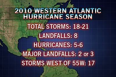
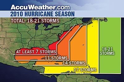
[ Bericht 1% gewijzigd door #ANONIEM op 21-06-2010 22:59:23 ]
Die depressie bij Venezuela en de Bovenwindse eilanden gaat inderdaad Alex worden, hij krijgt zelfs al enigszins de vorm van een hurricane. Er hangt ook nog een sliert bewolking achter dat volgens mij nummer 2 gaat worden. En ik zag dat voor van de Kaapverdische eilanden zich ook e.e.a. ontwikkeld. Kijken wat dat gaat doen. Morgen verlaat ik het Caribische gebied gelukkig weer
Net nieuwe update gezien, nu 50% kans op tropische storm. En aan de Pacific kant gaat het ook lekker, Celia naar categorie 2 en het systeem erachter 60% kans op ontwikkeling.
quote:9:30PM EDT Update 21 June 2010
The first signs of a low level circulation are beginning to appear, upping chances for development to about 50%. The circulation is roughly around 14.0N 72.0W. Assuming it maintains itself, it may be upgraded to a depression tomorrow, or more likely after recon gets out there on Wednesday.
Models are still a bit too soon to believe, the latest GFDL run appears too far to the north.

quote:6PM EDT Update 21 June 2010
The wave in the Eastern Caribbean Sea (93L) is a rather large system, but currently lacks a low level circulation. Conditions around it support a low chance for tropical development, but if it can hold together the largest chances will be when it reaches the western Caribbean sea later in the week.
Earlier forecast model runs overdid the system. This system has a better chance to develop than last week's 92L, but still the overall odds are against development. The most likely scenario is that it remains a wave or a tropical depression and moves its way into the Yucatan. While the system does not have a low level circulation, models won't be of much use.
Watching the model trends over the week, and signs for more circulation is important. There is a recon flight scheduled out for Wednesday, which is probably the best opportunity for real data and I don't expect it to be upgraded (if it is at all) before that.
Again the June factor along with the Jet are probably the biggest factors against development right now. If it has a circulation when it enters the west Caribbean, then chances go up quite a bit and could actually form into something.
In short watch it closely, but ihe wave known as 93L is most likely to impact Mexico with rain.
En nu is de kans dat Alex ontstaat weer kleiner geworden. Maar daar gaat het niet om, de tropical waves daarachter zien er erg veelbelovend uit.
's Avonds een man, overdags rustig an
Atlantic Tropical Storm/Hurricane Formation Possible by the End of June
Judging by the overall weather pattern and ideas from several computer models, the odds are increasing for tropical cyclone formation in the western Atlantic Basin before the end of the month.
At the very least, a period of rough seas and strong thunderstorms will affect part of the Gulf of Mexico next week.
AccuWeather.com Hurricane and Long Range Expert Meteorologist Joe Bastardi assimilates the current weather pattern in the Atlantic Basin to a "tropical brew that is ready to boil over."
Water temperatures in the Gulf of Mexico, Caribbean and the Southwest Atlantic are already very warm, compared to normal.
Tropical waves of low pressure rolling westward from Africa are already very active and are progressively becoming more vigorous.
One wave, bound to cause trouble, is currently drifting slowly westward through the central Caribbean and will deliver gusty, drenching thunderstorms to Hispaniola, where Haiti is located, today.
There is an abundance of showers and thunderstorms in the Caribbean, which represents plenty of "potential energy" for tropical cyclone formation.
Some computer models are developing the tropical wave in the Caribbean later this week.
These models go so far as to spin up the first tropical storm of the Atlantic season. At least one of these models develops a hurricane over the Gulf of Mexico between the 28th and 30th.
The first name on the 2010 list in the Atlantic is "Alex."
Another tropical system is forecast by computer models to take shape shortly thereafter east of the Bahamas.
Bastardi has warned of the potential for 20 tropical cyclones in the Atlantic Basin this season. Tropical cyclones are tropical storms and hurricanes; in other words, named systems.
While the oil spill area and other coastal regions and islands will dodge some bullets, the odds of multiple tropical storms and/or hurricanes tracking over the oil spill and other locations are exceptionally high this year, due to the number of named systems expected.
Disruptions caused by multiple hurricanes to oil spill cleanup and containment operations are one matter, the potential damage and destruction to coastal areas from wind and storm surge near and well away from the oil slick, takes this season to a whole new level.
Residents, business owners and government officials need to have a plan of action for what may be an exceptional hurricane season.
While the strength of the system forecast to enter the Gulf of Mexico late this weekend into early next week is questionable, there is the risk of squalls and building seas in the vicinity of the oil slick and cleanup/containment operations for up to a several-day period.
Bron
Judging by the overall weather pattern and ideas from several computer models, the odds are increasing for tropical cyclone formation in the western Atlantic Basin before the end of the month.
At the very least, a period of rough seas and strong thunderstorms will affect part of the Gulf of Mexico next week.
AccuWeather.com Hurricane and Long Range Expert Meteorologist Joe Bastardi assimilates the current weather pattern in the Atlantic Basin to a "tropical brew that is ready to boil over."
Water temperatures in the Gulf of Mexico, Caribbean and the Southwest Atlantic are already very warm, compared to normal.
Tropical waves of low pressure rolling westward from Africa are already very active and are progressively becoming more vigorous.
One wave, bound to cause trouble, is currently drifting slowly westward through the central Caribbean and will deliver gusty, drenching thunderstorms to Hispaniola, where Haiti is located, today.

There is an abundance of showers and thunderstorms in the Caribbean, which represents plenty of "potential energy" for tropical cyclone formation.
Some computer models are developing the tropical wave in the Caribbean later this week.
These models go so far as to spin up the first tropical storm of the Atlantic season. At least one of these models develops a hurricane over the Gulf of Mexico between the 28th and 30th.
The first name on the 2010 list in the Atlantic is "Alex."
Another tropical system is forecast by computer models to take shape shortly thereafter east of the Bahamas.
Bastardi has warned of the potential for 20 tropical cyclones in the Atlantic Basin this season. Tropical cyclones are tropical storms and hurricanes; in other words, named systems.

While the oil spill area and other coastal regions and islands will dodge some bullets, the odds of multiple tropical storms and/or hurricanes tracking over the oil spill and other locations are exceptionally high this year, due to the number of named systems expected.
Disruptions caused by multiple hurricanes to oil spill cleanup and containment operations are one matter, the potential damage and destruction to coastal areas from wind and storm surge near and well away from the oil slick, takes this season to a whole new level.
Residents, business owners and government officials need to have a plan of action for what may be an exceptional hurricane season.
While the strength of the system forecast to enter the Gulf of Mexico late this weekend into early next week is questionable, there is the risk of squalls and building seas in the vicinity of the oil slick and cleanup/containment operations for up to a several-day period.
Bron
Interessant...quote:Models different: Large Hurricane in Gulf possible... or not?
I wrote yesterday that little global model support existed for the tropical wave that is lurking in the eastern Caribbean Sea. That is beginning to change. A tremendous amount of energy is gathering in the region over water that is exceptionally warm for this time of year. What I am beginning to see in the computer models is beginning to concern me.
First of all, the upper level pattern is evolving in a manner which would allow for development. A large area of light winds aloft is setting in across the western Caribbean and Gulf of Mexico over the next several days and this could allow for the system, labeled 93L, to get going. The track suggests a movement across the Caribbean Sea and possibly towards the Yucatan peninsula. From there, the global models that recognize the potential for development turn the system northward in to the Gulf of Mexico. This is certainly going to cause a stir once news begins to spread of this potential. In fact, the very latest ECMWF model, linked here suggests we really need to keep an eye on the evolution of this feature. I am not going to sugar coat the reality here- there is potential for a significant storm or even a hurricane somewhere in the Gulf of Mexico over the next week. This is not a season to pretend the hurricanes away and worry about being sensational. Water temps are well above normal, ocean heat content is already very high and to see this kind of activity originating from an African tropical wave in June is very serious.
n the short term, Haiti and surrounding land masses are in for periods of heavy, tropical rains. This is not at all what is needed down there in light of the devastating earthquake. It is going to take a while for this system to move past the area as it is not moving very fast.
In addition, another strong tropical wave well east of the Lesser Antilles is beginning to flare up. It went from being bone-dry (embedded in fairly substantial dry air known as SAL for Saharan Air Layer) to bursting with convection in a hurry. There is going to be a lot to keep up with this last week of June.

Het lijkt erop dat Darby Mexico gaat treffen.
Celia heeft een mooi oog gekregen.
[ Bericht 7% gewijzigd door #ANONIEM op 23-06-2010 19:14:08 ]
Celia heeft een mooi oog gekregen.


[ Bericht 7% gewijzigd door #ANONIEM op 23-06-2010 19:14:08 ]
Hier sturen ze hem ook steeds meer de Golf in.quote:Op woensdag 23 juni 2010 14:48 schreef Frutsel het volgende:
[ afbeelding ]
Voorlopige uitdraai voor 28e... waar ligt die daar voor de kust?
De kans dat de olie straks door de lucht vliegt wordt steeds groter.
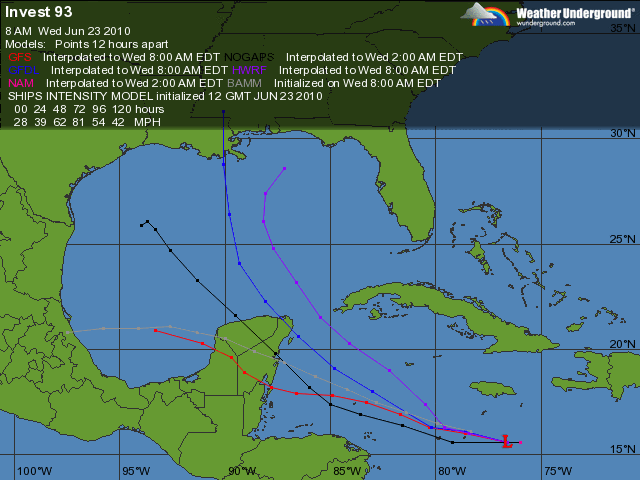
[ Bericht 8% gewijzigd door #ANONIEM op 23-06-2010 19:50:03 ]
leuk met onweer erbij.. extra vuurwerk?quote:Op woensdag 23 juni 2010 19:20 schreef aloa het volgende:
[..]
Hier sturen ze hem ook steeds meer de Golf in.
De kans dat de olie straks door de lucht vliegt wordt steeds groter.
[ afbeelding ]
| Wordfeud: marcel-o |plug.dj/uptempo |<-- draai zelf je platen
quote:Op woensdag 23 juni 2010 19:20 schreef aloa het volgende:
[..]
Hier sturen ze hem ook steeds meer de Golf in.
De kans dat de olie straks door de lucht vliegt wordt steeds groter.
[ afbeelding ]
Nature stricks back!!
Laten we hopen dat de mensheid hier iets van leert.
Daar leert men niets van... helaas.quote:Op woensdag 23 juni 2010 21:44 schreef Revolution-NL het volgende:
[..]
Nature stricks back!!
Laten we hopen dat de mensheid hier iets van leert.
Ik vraag me af wat er met die olie gebeurt als er een orkaan overheen trekt. Als hier een storm van windkracht 10 overtrekt, dan zit het zout ook tot ver in het land op de ramen.
Kans gestegen naar 40%
quote:A TROPICAL WAVE LOCATED OVER THE WESTERN CARIBBEAN SEA CONTINUES TO
PRODUCE SHOWERS AND A FEW THUNDERSTORMS ACROSS PORTIONS OF
HISPANIOLA...JAMAICA...CUBA...THE CAYMAN ISLANDS...AND THE ADJACENT
WATERS OF THE NORTHERN CARIBBEAN SEA. ALTHOUGH THE LOW-LEVEL
CIRCULATION OF THE WAVE APPEARS TO BE IMPROVING...THE ASSOCIATED
SHOWER ACTIVITY STILL LACKS ORGANIZATION AND IS LOCATED MAINLY TO
THE EAST OF THE WAVE AXIS. UPPER-LEVEL WINDS APPEAR CONDUCIVE FOR
SOME SLOW DEVELOPMENT OF THIS SYSTEM AS IT MOVES WESTWARD OR
WEST-NORTHWESTWARD AROUND 10 MPH OVER THE NEXT COUPLE OF DAYS. AN
AIR FORCE RESERVE UNIT RECONNAISSANCE AIRCRAFT IS TENTATIVELY
SCHEDULED TO INVESTIGATE THE SYSTEM THIS AFTERNOON...IF NECESSARY.
THERE IS A MEDIUM CHANCE...40 PERCENT...OF THIS SYSTEM BECOMING A
TROPICAL CYCLONE DURING THE NEXT 48 HOURS. WIDESPREAD SHOWERS AND
THUNDERSTORMS ARE ALSO AFFECTING PUERTO RICO AND THE NORTHERN
LEEWARD ISLANDS BUT ARE NOT DIRECTLY ASSOCIATED WITH THE TROPICAL
WAVE.
Yupquote:Op woensdag 23 juni 2010 14:48 schreef Frutsel het volgende:
[ afbeelding ]
Voorlopige uitdraai voor 28e... waar ligt die daar voor de kust?
De olie komt dan gewoon letterlijk uit de lucht vallenquote:Op woensdag 23 juni 2010 23:07 schreef aloa het volgende:
Ik vraag me af wat er met die olie gebeurt als er een orkaan overheen trekt. Als hier een storm van windkracht 10 overtrekt, dan zit het zout ook tot ver in het land op de ramen.
En dat over een behoorlijke afstand.quote:Op donderdag 24 juni 2010 10:59 schreef Revolution-NL het volgende:
[..]
De olie komt dan gewoon letterlijk uit de lucht vallen

quote:The first signs of development could happen any time from later today through Saturday, perhaps followed by rapid strengthening early next week.
A track of a hurricane toward the central or southeastern Louisiana coast would be the worst case scenario given the current situation. Counterclockwise flow around the storm would bring significant amounts of water (and oil and tar balls) onshore as a surge. Winds in the northeastern quadrant of a hurricane moving northward are typically the strongest and would also be a concern.
Speculation will continue as to what would happen if a hurricane tracks over an oil slick the size of the spill in the northern Gulf of Mexico. However, it appears likely that we will all get an education this season, sooner or later.
http://www.accuweather.co(...)-storm-hurrica-1.asp
[ Bericht 5% gewijzigd door #ANONIEM op 24-06-2010 12:15:38 ]
Alex komt er toch echt aan hoor.... Gestegen tot 60% en nu het warmere wateren binnenkomt ga ik er 99% vanuit dat het een orkaan gaat worden,
Aan de Pacific kant is Celia gestegen tot een categorie 5 en is Darby geupgrade naar een categorie 1.
Aan de Pacific kant is Celia gestegen tot een categorie 5 en is Darby geupgrade naar een categorie 1.
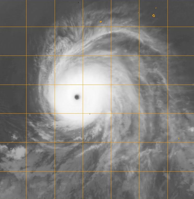
quote:Op vrijdag 25 juni 2010 04:46 schreef Vogue het volgende:
Alex komt er toch echt aan hoor.... Gestegen tot 60% en nu het warmere wateren binnenkomt ga ik er 99% vanuit dat het een orkaan gaat worden,
Aan de Pacific kant is Celia gestegen tot een categorie 5 en is Darby geupgrade naar een categorie 1.
Wanneer komt hij over de golf van Mexico is de verwachting?
quote:8 PM EDT Update 24 June 2010
The wave now entering the west Caribbean (93L) has reached far enough west to kick up the chances to 60%, if it were to develop tomorrow seems the most likely time, especially if it develops convection overnight.
It is expected to near Honduras/Nicaragua, but stay to the north and head into the Yucatan, it likely will have a chance to develop then. Once back in the gulf it may have a chance to strengthen, but it seems shear/dry air may enter into the equation the further north it gets. Those in the Yucatan and Gulf states need to monitor the wave.
7 AM EDT Update 24 June 2010
The wave in the Caribbean, with an apparent low level circulation southwest of Jamaica, is still holding on, but is taking the slow road toward development. The window for development is tonight through Saturday. The most likely scenario, still, is for it to enter the Yucatan with rain, and it may not develop before it gets there (or very late).
Models are very divergent on where it may eventually go, but the weaker condition of the storm suggests more westerly into the Yucatan. In short, in common with most undeveloped systems, they are still mostly unhelpful.
In short not much has changed with this all week, and it is still very worth watching in the Gulf and Yucatan for changes.
Currently Recon is scheduled to go out there this afternoon, it may be canceled if it doesn't look more organized close to then
Zondag op Maandag denk ikquote:
[..]
Wanneer komt hij over de golf van Mexico is de verwachting?
Wat een monsterquote:
Apart dat ze hem eerst als cat.2 classificeren... dan ineens als 3... dan weer 2 en nu ineens ee vijf
Idd.. en dat nu al in juni..quote:Op vrijdag 25 juni 2010 09:22 schreef Frutsel het volgende:
[..]
Wat een monster
Apart dat ze hem eerst als cat.2 classificeren... dan ineens als 3... dan weer 2 en nu ineens ee vijf
Tis volgens mij de 2e Cat.5 orkaan in de geschiedenis van de Oostpacific, die ontstaat in Juni. Alleen orkaan Ava uit 1973 ontstond eerder dan Celiaquote:
Wow .. zeldzaam dusquote:Op vrijdag 25 juni 2010 11:21 schreef Frutsel het volgende:
[..]
Tis volgens mij de 2e Cat.5 orkaan in de geschiedenis van de Oostpacific, die ontstaat in Juni. Alleen orkaan Ava uit 1973 ontstond eerder dan Celia
Ondertussen lijkt Darby toch ook sterk te worden nu al minstens Cat.3 verwachting

Hopelijk zwakt tie genoeg af voordat hij richting land gaat.
Hij zal vast nog wel afzwakken...
Ben erg benieuwd hoe het in de Carribean zal gaan dit weekend. Ik vind de buien er niet spannend uitzien in de zin van vorming van een orkaan, maar toch 60% kans. Ben benieuwd.
Ben erg benieuwd hoe het in de Carribean zal gaan dit weekend. Ik vind de buien er niet spannend uitzien in de zin van vorming van een orkaan, maar toch 60% kans. Ben benieuwd.
's Avonds een man, overdags rustig an
Die 80% depressie zal over Yucatan gaan en dan de Golf intrekken...
's Avonds een man, overdags rustig an

Zal me niets verbazen als we binnenkort 2 namen hebben in de Atlantische Oceaan. De boel is behoorlijk aan het ontploffen.


quote:Atlantic Has Its First Tropical Depression of 2010 Season
The depression is currently located 355 miles southeast of Cozumel, Mexico and has maximum sustained winds of 35 mph.
The tropical brew of showers, thunderstorms and tropical waves in the Caribbean Sea has given birth to the first tropical depression of the 2010 Atlantic hurricane season on Friday.
Tropical Depression One is forecast by AccuWeather.com meteorologists to soon become a tropical storm, and then possibly a hurricane over the next several days. The depression is currently located 355 miles southeast of Cozumel, Mexico and has maximum sustained winds of 35 mph.
The first name on the list of Atlantic tropical cyclones this season is "Alex."
The depression destined to become Alex will drift across the Yucatan, Mexico this weekend, producing heavy rain and gusty thunderstorms. There is an elevated risk of flash flooding and mudslides over a broad area of Central America as a result of the system drifting slowly to the northwest.
A window of movement ranging from Louisiana to Tamaulipas, Mexico exists for possible storm tracks next week, as the system is expected to emerge on the northwestern side of the Yucatan Peninsula later Sunday.
Waters are very warm in the western Caribbean and in much of the Gulf of Mexico. While the system will battle with the Yucatan Peninsula this weekend, strengthening prior to and after engaging the land mass is inevitable.
The system will pull a great deal of tropical moisture northward on its eastern side. As a result, regardless of the exact track, squalls and building seas are likely not only over the central and southwestern Gulf of Mexico, but also over eastern areas.
While a track over the southwestern Gulf of Mexico would mean substantially less impact on the oil spill area, building seas and gusty thunderstorms from the tropical vale of moisture could cause some hazards and disruptions.
A track over the central and northern Gulf of Mexico would mean the roughest conditions, and prove to be the most disruptive over the oil spill area. A south to southeasterly flow on the eastern flank of such a storm track would drive the most oil toward the central Gulf Coast.
In either case, the earliest we would have landfall would be late Tuesday into Wednesday. There is some possibility of the system's forward speed slowing, which would keep nail biting going through next week.


[ Bericht 3% gewijzigd door #ANONIEM op 26-06-2010 08:31:13 ]


NEW ORLEANS - De eerste tropische storm van dit seizoen vormt zich boven de Caribische eilanden en dreigt richting de Golf van Mexico te gaan.
Het Amerikaanse Orkaancentrum (NHC) maakte zaterdag bekend dat de storm nu al windsnelheden van 55 kilometer per uur telt.
De storm zal naar verwachting in de loop van de week in kracht toenemen en dwars door het gebied razen waar duizenden liters olie op het water drijven.
Gevreesd wordt dat de werkzaamheden aan het olielek in de Golf van Mexico door de storm gehinderd zullen worden. Ook leeft de angst dat de wind nog meer olie aan land zal blazen.
Kwetsbare natuurgebieden
De kustgebieden van de staten Louisiana, Mississipi, Alabama en Florida kampen al met olie op de stranden en in de kwetsbare natuurgebieden. Ook het toerisme wordt door de olieramp flink geraakt. De kustwacht zegt geen idee te hebben wat te verwachten van het effect van de storm op de olie. ''Dit is de eerste keer en we hebben geen draaiboek'', aldus een woordvoerder.
De olielekkage die is ontstaan door het zinken van Deepwater Horizon eind april is de grootste in de geschiedenis van de VS. Tientallen miljoenen liters ruwe olie zijn in zee gestroomd. Olieproducent BP probeert met man en macht het lek te dichten, maar is daar ondanks verscheidene pogingen nog niet in geslaagd.
Als het hogedrukgebied boven de VS verdrongen wordt door het lagedrukgebied in het noorden, dan kan Alex wel eens recht over de oil spill gaan en recht afstevenen op New Orleans... Wordt echt spannend de komende dagen. Al scheelt het wel dat Alex geen cat. 2 of hoger hurricane zal worden.
's Avonds een man, overdags rustig an
quote:As Tropical Storm Alex pushes northwestward, it will unleash tremendous thunderstorms, torrential downpours, and flooding to portions of Central America and southeastern Mexico this weekend.
The large, slow-moving nature of Alex could result in great loss of life in unprotected, unsuspecting areas.
Big, slow-moving, repeating thunderstorms will fire over the water and nearby areas from Honduras, Guatemala and Belize to Mexico's Yucatan, Chiapas, Campeche, Quintana Roo and Tabasco states.
Daytime heating, combined with excess tropical moisture, will fuel the thunderstorms over land areas, while the tropical nature of the system will brew thunderstorms over nearby waters. A circulation around Alex will drive the ocean-bred thunderstorms onshore.
While the developing situation is of great concern to the Gulf of Mexico early next week, the immediate concern for these countries is that of life-threatening flash flooding and mudslides.
Renewed strengthening of Alex is expected over the southwest Gulf of Mexico early next week. Alex is forecast by AccuWeather.com to become a strong tropical storm or hurricane before a second landfall next week on a track favoring a more westward, rather than northward movement.
The size, strength and track of Alex over the southwest Gulf of Mexico next week will determine the amount of rainfall and the nature of flooding in the Vera Cruz, Nuevo Leon and Tamaulipas states in Mexico and perhaps part of the Texas coast of the U.S.
While Alex is still being pushed steadily along by stronger-than-usual easterlies, as the storm moves more to the northwest with time, the tropical easterly flow weakens and could result in decreased forward speed of the storm from mid- to late week. Hence, the continued concern for flooding.

Het ziet ernaar uit dat deze niet over de olie heen gaat, maar ik ga er van uit dat er de komende weken wel eentje daar in de buurt gaat komen...
Waarom niet dan is het meteen mooi netjes opgeruimd uit zee en ligt het op landquote:Op zaterdag 26 juni 2010 17:25 schreef kahaarin het volgende:
Hmm, ik hoop echt dat het de olierampspot gaat missen.
Maar als het zover komt dan is het een mooie reden om verder te kijken naar alternatieve energie
Wat een enorm systeem zeg.
Als het de golf van mexico induikt gaat het wel nog de orkaanstatus bereiken. De meeste modellen sturen hem nu richting Mexico i. p .v de amerikaanse kust.
Als het de golf van mexico induikt gaat het wel nog de orkaanstatus bereiken. De meeste modellen sturen hem nu richting Mexico i. p .v de amerikaanse kust.
quote:Olie-industrie vreest storm Alex
De olieindustrie in de Golf van Mexico maakt zich zorgen over tropische storm Alex. Oliemaatschappij Shell is bezig om personeel te evacueren van booreilanden in de buurt. Ook BP volgt storm Alex nauwkeurig.
Alex is de eerst tropische storm van het seizoen.
Vooralsnog lijkt er geen gevaar voor de schepen die aan het werk zijn rond het olielek bij het gezonken platform Deepwater Horizon, maar het Amerikaanse orkaancentrum waarschuwt dat de storm onvoorspelbaar is.
Op dit moment nadert de storm het Mexicaanse schiereiland Yucatan. Enkele honderden toeristen zijn op de vlucht geslagen voor de storm.
http://nos.nl/artikel/167785-olieindustrie-vreest-storm-alex.html


idd
Achter Alex zit nu ook dat nieuwe gebied... Maar dat lijkt weinig potentie tot ontwikkeling te hebben.
Achter Alex zit nu ook dat nieuwe gebied...
GFS blijft volhouden dat Alex ergens bij Houston Landfall gaat maken. Een ander model heeft de storm nu ook wat noordelijker staan.
Het begint er steeds meer op te lijken dat GFS gelijk gaat krijgen. Nu 3 modellen, die ook een meer noordelijker koers aangeven.

Vergelijk onderstaande kaarten maar:quote:Op maandag 28 juni 2010 00:08 schreef Co_OL het volgende:
Waar ligt die plas met olie eigenlijk?

Of:
http://www.ifitwasmyhome.com/#x=-87.46687043750002&y=22.319721352861134&z=5
http://www.hln.be/hln/nl/(...)ntraal-Amerika.dhtmlquote:Tropische storm Alex eist 10 doden in Centraal-Amerika
De tropische storm Alex heeft minstens tien doden geëist in Nicaragua, Guatemala en El Salvador. De storm veroorzaakte overstromingen en aardverschuivingen.
Alex was zondagochtend aanzienlijk afgezwakt, maar won 's avonds opnieuw aan kracht. Het hevige noodweer zorgde voor minstens tien doden.
Vanochtend omstreeks 5 uur haalt Alex windsnelheden tot 75 kilometer per uur. De storm bevind zich ter hoogte van Campeche en staat op het punt over de Golf van Mexico te razen.
Volgens het Amerikaans National Hurricane Center (NHC) kan Alex in de komende 48 uur uitgroeien tot orkaan. Hij zal wellicht niet over het door olie vervuilde gebied trekken, maar zal vermoedelijk wel de opruiming van de olie bemoeilijken. (belga/vsv)
Valt mee dus.quote:Op maandag 28 juni 2010 10:06 schreef Hydrogeny het volgende:
[..]
Vergelijk onderstaande kaarten maar:
[ afbeelding ]
[ afbeelding ]
Of:
http://www.ifitwasmyhome.com/#x=-87.46687043750002&y=22.319721352861134&z=5
Hij zit nu op zo'n 80 km/uur. Volgens het kaartje gaat ie naar zo'n 177 km/uur en dat is bijna een categorie 3.

En hoe noordelijker de verwachtingen worden hoe heviger het kan worden.quote:Op maandag 28 juni 2010 11:48 schreef aloa het volgende:
Hij zit nu op zo'n 80 km/uur. Volgens het kaartje gaat ie naar zo'n 177 km/uur en dat is bijna een categorie 3.
quote:Op maandag 28 juni 2010 11:33 schreef Vogue het volgende:
[..]
Op de kaart lijkt het mee te vallen, maar het gebied is ruim 2 keer zo groot als Nederland
Ik bedoel meer dat dat hij niet rechtstreeks over het getroffen gebied gaat.
Ligt er aan toch? Als hij de rechterkant van het rode gedeelte aanhoud op bovenstaand kaartje? Geen idee hoe breed hij dan is maar het zal toch best wel gaan klotsen op zee daar. Waar hebben we het over indien hij cat 4 is rond donderdagmiddag? 500KM?quote:Op maandag 28 juni 2010 12:40 schreef Revolution-NL het volgende:
[..]
Ik bedoel meer dat dat hij niet rechtstreeks over het getroffen gebied gaat.
Edit: Plaatje
Als ik uitgaan van een olievlek (net zo lang als NL) en orkaan wordt 500KM... zitten we nog steeds veilig toch?

Hoe zit het eigenlijk met ALS hij er recht op af gaat? Wordt hij veel sterker door alle olie of valt hij hij stil?
[ Bericht 24% gewijzigd door Hydrogeny op 28-06-2010 12:57:46 ]
quote:Op maandag 28 juni 2010 12:49 schreef Hydrogeny het volgende:
[..]
Ligt er aan toch? Als hij de rechterkant van het rode gedeelte aanhoud op bovenstaand kaartje? Geen idee hoe breed hij dan is maar het zal toch best wel gaan klotsen op zee daar. Waar hebben we het over indien hij cat 4 is rond donderdagmiddag? 500KM?
Edit: Plaatje
Als ik uitgaan van een olievlek (net zo lang als NL) en orkaan wordt 500KM... zitten we nog steeds veilig toch?
[ afbeelding ]
Hoe zit het eigenlijk met ALS hij er recht op af gaat? Wordt hij veel sterker door alle olie of valt hij hij stil?
Ik heb er verder geen verstand van dus geen idee. Ik weet wel dat als de de orkaan recht over de getroffengebieden gaat de olie letterlijk de lucht in word geslingerd. De kans is groot dat de olie dan op land letterlijk uit de lucht komt vallen
Zo te zien gaat het gelukkig meevallen
quote:The longer Alex churns, the bigger and stronger it will get
AccuWeather.com meteorologists forecast Alex to keep strengthening over the warm waters of the western Gulf of Mexico, and the longer it churns, the stronger of a hurricane it could become.
The storm is currently expected to reach Category 2 strength around midweek over the western Gulf of Mexico. AccuWeather.com Chief Long-Range Meteorologist and Hurricane Forecaster Joe Bastardi forecasts Alex to become an even stronger hurricane--a Category 3 strength storm.
With the current projected path, landfall is expected somewhere between the vicinity of Victoria, Texas, to Tampico, Mexico sometime early Thursday.
In this scenario, the brunt of the storm will stay away from the oil spill area, but wave swells of at least 5-7 ft. and a broadened, strengthened wind field could push oil even farther into Gulf Coast beaches.
Hoe trager, des te meer regen hij dumpt en des te meer tijd dat hij straks krijgt om cat.3 te worden
Ik sprak een paar weken geleden nog een Amerikaan die tussen Miami en de Keys woont. Hij vond het vanwege het klimaat de fijnste plek om te wonen. Tsja, hurricanes heb je wel zei hij, maar daar kan je je op voorbereiden. In California heb je ook een goed klimaat, maar daar heb je earthquakes, dan had hij toch liever een orkaan. Kan ik inkomen

Het is nog steeds een tropische storm nu met 105 km/uur.
Het lijkt wel een grote storm te worden ( in omvang.)
Het lijkt wel een grote storm te worden ( in omvang.)
Inmiddels 112 km/uur en windstoten boven de 120 km/uur. Gaat niet lang meer duren voordat het een orkaan categorie 1 is.

Mexico gaat hard gepowned worden. Wat een gigantische storm is het toch zeg...
's Avonds een man, overdags rustig an
Hoe zit het met dat warmte gebied tussen Alex en de olievlek? Kan dit nog iets aan de richting doen veranderen? Olie wordt toch ook sneller warm? Wordt het daar niet juist gevaarlijk?
Volgens mij ligt de olievlek noordelijker, voor de kust van Louisiane richting Florida
Denk dat de koers nu wel zon beetje vast ligt en hij op de grens van Texas en Mexico aan land gaat. (in harlingen)
zie wel dat hij inmiddels weer opgewaardeerd is. Vanochtend gaven ze hem als cat.1 orkaan bij landfall, nu is dat inmiddels weer een categorie 2 orkaan.
Hij gaat extreem traag.. zou niet voor het eerst zijn dat ze er naast zitten qua enorme groei in kracht en dat het nog een drie wordt.
Denk dat de koers nu wel zon beetje vast ligt en hij op de grens van Texas en Mexico aan land gaat. (in harlingen
zie wel dat hij inmiddels weer opgewaardeerd is. Vanochtend gaven ze hem als cat.1 orkaan bij landfall, nu is dat inmiddels weer een categorie 2 orkaan.
Hij gaat extreem traag.. zou niet voor het eerst zijn dat ze er naast zitten qua enorme groei in kracht en dat het nog een drie wordt.
Hoge golven jagen olievegers naar de wal
(Novum/AP) - Hoge golven en aanwakkerende wind veroorzaakt door de tropische storm Alex hebben dinsdag olie-opvegende schepen in de Golf van Mexico naar de wal gejaagd. Alle opruimwerkzaamheden voor de kust van Louisiana, Florida, Alabama en Mississippi zijn opgeschort totdat het weer beter wordt.
reacties (0)printstuur artikel door
'Alex' blijft naar verwachting op ruime afstand van het olielek, maar de uitlopers van de zich ontwikkelende orkaan veroorzaken in het rampgebied harde windvlagen en metershoge golven.
De enige schepen die nog op zee zijn helpen bij het opvangen of verbranden van olie en gas, of bij het boren van een nieuw gat dat de druk op de oliespuiter moet verminderen.
Trouw
Gifje van Frutsel begint er ook steeds heftiger uit te zien. Ben benieuwd wat ons morgen brengt. Tot nu toe wordt hij niet sterker.
De eerste Juni orkaan sinds 1995 in de Atlantische Oceaan.

quote:Alex is First June Hurricane in Atlantic Since 1995
Alex not only became the first hurricane of the 2010 Atlantic season late on Tuesday, but also the first hurricane to form in June since 1995.
Alex intensified into a hurricane at 10 p.m. CDT on Tuesday when maximum-sustained winds increased to 75 mph.
Maximum-sustained winds were 80 mph at 1 a.m. CDT on Wednesday. The storm at that time was located about 195 miles east-southeast of La Pesca, Mexico, and 255 miles southeast of Brownsville, Texas.
Further strengthening should take place before Alex slams onto the northeastern Mexico coast on Wednesday evening. Prior to landfall, Alex is expected to reach Category 2 hurricane status with winds of at least 96 mph.
Alex will threaten lives and property across northeastern Mexico and South Texas by unleashing flooding rain and powerful winds. Northeastern Mexico will bear the brunt of Alex's most destructive winds.
Have a question about Alex or hurricanes in general? Ask our expert meteorologists on Facebook.
Hurricane Alex marks the beginning of what AccuWeather.com Chief Hurricane Meteorologist Joe Bastardi has forecast as an extremely active Atlantic hurricane season. Bastardi is expecting a total of 18 to 21 named storms.
The start of this 2010 Atlantic hurricane season will also go down in history books as unusually active. Alex is the first Atlantic Basin hurricane to form in June in 15 years. The last June hurricane to develop in the Atlantic was Allison in 1995.
Allison intensified into a Category 1 hurricane in the eastern Gulf of Mexico on June 4, 1995. The storm weakened back to a tropical storm less than 24 hours later, prior to making landfall along the Florida Panhandle.
In the past 43 years, August 10 is the average date when the first hurricane has formed in the Atlantic Basin. The average date for the first tropical storm is not even in June, but is actually on July 9.
quote:Op dinsdag 29 juni 2010 23:00 schreef Hydrogeny het volgende:
Gifje van Frutsel begint er ook steeds heftiger uit te zien. Ben benieuwd wat ons morgen brengt. Tot nu toe wordt hij niet sterker.
Is gifje uit de Openingspost op pagina 1
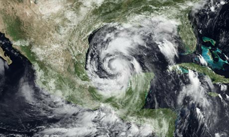
Kan nog steeds een cat.2 wordenquote:Alex is slowly strengthening, in fact, recent recon reports indicate that pressure has fallen to 959, which means Alex may become a Category 2 hurricane today.
Forecasted track is still into Mexico, with most of the energy on the right (or northern side) of the center, those in Brownsville and the Rio Grande Valley will be seeing deteriorating conditions today into tonight.
Zoals zo veel natuurfenomenen, het ziet er fantastisch uit maar dit hoef ik niet per-se aan den lijve te ondervinden. Hopelijk valt het een beetje mee en gaat het niet richting cat 3, dit zal al wel genoeg overlast veroorzaken.
be nice or go away
Ja, en je moet eens naar de Pacific kant kijken Daar komen ze ook tot halverwege. Bijzondere orkaan dit.

Blijft aan kracht toenemen, verwacht eigenlijk wel dat hij morgenvroeg al cat 2 is. Zie nog nergens berichten van olieproblemen

videoquote:South Padre Island, Texas (CNN) -- Residents of southern Texas and northeastern Mexico braced for tornadoes and flooding as Hurricane Alex lashed a sparsely populated area south of the Texas border early Thursday morning.
The storm made landfall along the Mexican coastline late Wednesday as a Category 2 storm, about 100 miles south of Brownsville, Texas.
Maximum sustained winds were 100 mph as Alex moved to the west at 10 mph, the National Hurricane Center reported. Forecasters said the storm was expected to continue in that direction and move farther inland over northeastern Mexico Thursday.
Heavy rains could cause life-threatening flash floods and mudslides, especially in areas with mountainous terrain, the center said.
Shelters have opened throughout the Mexican state of Tamaulipas to house thousands of people affected by the rains, according to a statement from the office of the governor Wednesday night.
Tamaulipas is under "red alert," the statement said. Winds and rains from Alex are also expected to affect the Mexican states of Veracruz, Nuevo Leon and Coahuila.
Resident Claudia Aguirre told CNN that heavy rains had already caused many streets to flood Wednesday in the coastal city of Matamoros, Mexico, located across the border from Brownsville .
"We are getting bands of heavy rain and wind every 20 minutes," Matamoros resident Alexandro Hoopo said late Wednesday night.
At least 1,000 people in southern Texas were taking shelter in evacuation centers as Alex's winds and heavy rain squalls bore down on the coastline, officials in Cameron and Hidalgo counties reported.
quote:There is not much to add concerning Alex at this late hour. The hurricane made landfall as a 105 mph hurricane with a pressure of 947 millibars. This could have easily been a category three or four hurricane had it more time over water- considering the favorable upper level environment it had. Thankfully, the NHC indicates that Alex struck an area that is fairly sparse in terms of population. None the less, the people who experienced this record hurricane will never forget it
It will take some time for the large circulation of Alex to spin down and dissipate. As such, a large portion of the Gulf of Mexico coastline will continue to feel the effects until the center fills and the pressure comes up- this is already happening and will do so in a more rapid fashion throughout the day tomorrow.