WKN Weer, Klimaat en Natuurrampen
Lees alles over het onstuimige weer op onze planeet, volg orkanen en tornado's, zie hoe vulkanen uitbarsten en hoe Moeder Aarde beeft bij een aardbeving. Alles over de verwoestende kracht van onze planeet en tal van andere natuurverschijnselen.


Het Winterweer in de V.S.
De noordoostelijke staten van de USA
De winter in New England staat bekend als een koude winter. De wind is in het winterhalfjaar noordwestelijk en droge arctische lucht uit Canada stroomt ver naar het zuiden. Deze kou-invallen gaan soms gepaard met blizzards. Opdringende warme lucht uit het zuiden zorgt af en toe voor flinke ijzel.
Gemiddeld vriest het bij de Canadese grens in januari zo'n -13 graden. In New Jersey vriest het zo'n 5 graden. In het noordoostelijke puntje van New England daalt in januari de thermometer gemiddeld elke nacht tot -19 graden. De extremen in het gebied liegen er ook niet om. Op 19 januari werd het in Van Buren (Maine) -44,4 graden. Old Forge (New York) mat op 18 februari 1979 zelfs een minimum van -46,7 graden. Het zeewater daalt in januari en februari tot +4 graden in zowel Boston als in New York.
De zuidoostelijke staten van de USA
In de winter komt de gemiddelde kou tot Atlanta. In Maryland, Virginia, de Appalachen en de hoger gelegen staten als Kentucky vriest het veelvuldig. De ergste kou vinden we nog noordelijker in Michigan en Ontario. In West Virginia vinden we de allerlaagste temperatuur van het gebied terug. Op 30 december 1917 daalde in Lewisburg de thermometer tot -38,3 graden.
Het gebied langs de Golf van Mexico beleeft een relatief milde en korte winter. Toch kan het hier soms flink vriezen. Neem bijvoorbeeld de -28 graden die in Corinth (Mississippi) op 30 januari 1966 werd gemeten. In Florida neemt de invloed van de oceaan toe. Dit is vooral merkbaar aan de gemiddelde nachttemperatuur in het zuiden. In zeer uitzonderlijke situatie vriest het hier of valt er sneeuw. Op de Key's komt de temperatuur nooit onder nul. De allerlaagste temperatuur in Florida bedroeg -18,9 graden en werd gemeten in Tallahassee.
De staten Virginia, West Virginia en Maryland krijgen in de winter soms te maken met sneeuwstormen. Deze staan bekend als Nor'easters en komen oktober en april. Ze zijn berucht om de grote hoeveelheid sneeuw, regen en de flinke wind.
Een Nor'easter komt voor als een lagedrukgebied warme vochtige subtropische lucht uit de Golf van Mexico naar het noorden voert. De lucht wordt vermengd met vochtige lucht uit de Atlantische Oceaan. Een hogedrukgebied boven Canada biedt tegenwicht en stuwt arctische lucht naar het zuiden. Daar waar de luchtsoorten bij elkaar komen, ontstaat hevige neerslag.
De meest actieve Nor'easter is de sneeuwstorm die naar het oosten trekt en de straalstroom volgt. Vooral Washington DC, Philadelphia, New York City en Boston worden dan getroffen en krijgen grote hoeveelheden regen en sneeuw te verwerken.
Het midden van de Verenigde Staten
De winters in het noorden zijn streng. Bismarck in North Dakota heeft in januari een gemiddelde temperatuur van -12,7 graden. International Falls op de grens van Canada en Minnesota heeft zelfs een gemiddelde januari-temperatuur van -17,2 graden. De nachtelijke temperaturen bedragen hier gemiddeld -23,3 graden en de dagtemperatuur -11,2 graden.
De staten langs de Canadese grens en de Grote Meren krijgen ook in de winter vaak te maken met 'blizzards', die zeer koude lucht aanvoeren vanuit het arctische Canada. Het gebied is dan bedekt met een sneeuwlaag. Veel is dit niet. In januari valt er slechts enkele tientallen millimeters neerslag.
Veel nachten verlopen helder en de aanwezigheid van een sneeuwdek helpt mee aan een lage temperatuur. De allerlaagste temperatuur in North Dakota werd gemeten op 15 februari 1936. In Parshall werd het -51,1 graden. Op 2 februari 1996 gebeurde hetzelfde in Towar, Minnesota.
Naar het zuiden neemt de strengheid van de winter af. Tot in Kansas is de gemiddelde januaritemperatuur onder nul. In Texas loopt deze snel op. Niet alleen de zuidelijke ligging, maar ook de aanwezigheid van de Golf van Mexico speelt daarbij een rol. In Brownsville op de grens met Mexico is het in januari overdag 20,5 graden en incidenteel boven de 33 graden.
Toch krijgen relatief zuidelijk gelegen gebieden 's winters soms te maken met extreme koude situaties, doordat luchtstromen uit het hoge noorden van Canada hun weg zuidwaarts zoeken tussen de Rocky Mountains en de Appalachen. Zo was het in het ogenschijnlijk warme Texas op 3 februari 1933 in Seminole -30,6 graden.
Westen van de Verenigde Staten
In de winter heerst de meeste kou in de hoger gelegen delen van de Rocky Mountains. Arctische lucht uit Canada zorgt voor strenge winters in het noorden, zoals in Montana, Wyoming en Colorado. In Montana richt de snijdend koude wind geregeld slachtingen aan onder de veestapel. De allerlaagste temperatuur in Montana werd gemeten op 20 januari 1954. Op Rogers Pass werd het toen -56,7 graden onder nul.
In Wyoming waar ook lange strenge winters voorkomen, staat het minimumrecord op bijna -53 graden vorst. Het berggebied van Idao, Utah en Colorado is koud en sneeuwachtig. Vooral in Colorado valt veel sneeuw. Temperaturen tot onder de -50 graden zijn incidenteel mogelijk. De hoogvlakte van Nevada is eveneens koud. In Ely op 1900 meter hoogte vriest het in januari 's nachts zo'n -12,5 graden. Dit wordt tevens veroorzaakt door de vele heldere nachten in het gebied.
Warmer is het in Washington en Oregon. Het kan hier behoorlijk vriezen, maar aan zee is de winter relatief mild. De regen valt vooral tussen oktober en april. In de bergen gaat het dan om sneeuw en worden wegen afgesloten.
In het zuidwesten van Californië blijft het winters klimaat aangenaam en vriest het zelden. Het is daar dan ook regentijd. Toch kan de winter flink uithalen. Vooral in de Sierra Nevada is dat het geval. De allerlaagste temperatuur in Californië die is gemeten bedraagt -42,8 graden. In New Mexico tenslotte zijn de winters koel maar niet extreem koud.
Alaska
In de noordelijke Amerikaanse staat Alaska heersen verschillende klimaten. Zeestromingen, bergruggen en een lage zonnestand bepalen voornamelijk het klimaat. In het noorden komen poolwoestijnen voor, in het zuiden heerst een mild klimaat dat vergelijkbaar is met Nederland.
Bron:VWKWEB
De bedoeling van dit Topic is om het winterweer in de V.S. te volgen.
B.v. via onderstaande site's
Winter Weather cnn
Google News
temperatuurkaartje V.S.
temperatuurkaartje Alaska
vorige delen:
Topic Winterweer in de V.S: Snow, Blizzards and Storms (2007)
Winterweer in de VS (2008) - IJsstorm en bar winterweer
De huidige temperaturen in de V.S.
De huidige temperaturen in Alaska
[ Bericht 6% gewijzigd door #ANONIEM op 09-10-2009 19:28:43 ]

De noordoostelijke staten van de USA
De winter in New England staat bekend als een koude winter. De wind is in het winterhalfjaar noordwestelijk en droge arctische lucht uit Canada stroomt ver naar het zuiden. Deze kou-invallen gaan soms gepaard met blizzards. Opdringende warme lucht uit het zuiden zorgt af en toe voor flinke ijzel.
Gemiddeld vriest het bij de Canadese grens in januari zo'n -13 graden. In New Jersey vriest het zo'n 5 graden. In het noordoostelijke puntje van New England daalt in januari de thermometer gemiddeld elke nacht tot -19 graden. De extremen in het gebied liegen er ook niet om. Op 19 januari werd het in Van Buren (Maine) -44,4 graden. Old Forge (New York) mat op 18 februari 1979 zelfs een minimum van -46,7 graden. Het zeewater daalt in januari en februari tot +4 graden in zowel Boston als in New York.
De zuidoostelijke staten van de USA
In de winter komt de gemiddelde kou tot Atlanta. In Maryland, Virginia, de Appalachen en de hoger gelegen staten als Kentucky vriest het veelvuldig. De ergste kou vinden we nog noordelijker in Michigan en Ontario. In West Virginia vinden we de allerlaagste temperatuur van het gebied terug. Op 30 december 1917 daalde in Lewisburg de thermometer tot -38,3 graden.
Het gebied langs de Golf van Mexico beleeft een relatief milde en korte winter. Toch kan het hier soms flink vriezen. Neem bijvoorbeeld de -28 graden die in Corinth (Mississippi) op 30 januari 1966 werd gemeten. In Florida neemt de invloed van de oceaan toe. Dit is vooral merkbaar aan de gemiddelde nachttemperatuur in het zuiden. In zeer uitzonderlijke situatie vriest het hier of valt er sneeuw. Op de Key's komt de temperatuur nooit onder nul. De allerlaagste temperatuur in Florida bedroeg -18,9 graden en werd gemeten in Tallahassee.
De staten Virginia, West Virginia en Maryland krijgen in de winter soms te maken met sneeuwstormen. Deze staan bekend als Nor'easters en komen oktober en april. Ze zijn berucht om de grote hoeveelheid sneeuw, regen en de flinke wind.
Een Nor'easter komt voor als een lagedrukgebied warme vochtige subtropische lucht uit de Golf van Mexico naar het noorden voert. De lucht wordt vermengd met vochtige lucht uit de Atlantische Oceaan. Een hogedrukgebied boven Canada biedt tegenwicht en stuwt arctische lucht naar het zuiden. Daar waar de luchtsoorten bij elkaar komen, ontstaat hevige neerslag.
De meest actieve Nor'easter is de sneeuwstorm die naar het oosten trekt en de straalstroom volgt. Vooral Washington DC, Philadelphia, New York City en Boston worden dan getroffen en krijgen grote hoeveelheden regen en sneeuw te verwerken.
Het midden van de Verenigde Staten
De winters in het noorden zijn streng. Bismarck in North Dakota heeft in januari een gemiddelde temperatuur van -12,7 graden. International Falls op de grens van Canada en Minnesota heeft zelfs een gemiddelde januari-temperatuur van -17,2 graden. De nachtelijke temperaturen bedragen hier gemiddeld -23,3 graden en de dagtemperatuur -11,2 graden.
De staten langs de Canadese grens en de Grote Meren krijgen ook in de winter vaak te maken met 'blizzards', die zeer koude lucht aanvoeren vanuit het arctische Canada. Het gebied is dan bedekt met een sneeuwlaag. Veel is dit niet. In januari valt er slechts enkele tientallen millimeters neerslag.
Veel nachten verlopen helder en de aanwezigheid van een sneeuwdek helpt mee aan een lage temperatuur. De allerlaagste temperatuur in North Dakota werd gemeten op 15 februari 1936. In Parshall werd het -51,1 graden. Op 2 februari 1996 gebeurde hetzelfde in Towar, Minnesota.
Naar het zuiden neemt de strengheid van de winter af. Tot in Kansas is de gemiddelde januaritemperatuur onder nul. In Texas loopt deze snel op. Niet alleen de zuidelijke ligging, maar ook de aanwezigheid van de Golf van Mexico speelt daarbij een rol. In Brownsville op de grens met Mexico is het in januari overdag 20,5 graden en incidenteel boven de 33 graden.
Toch krijgen relatief zuidelijk gelegen gebieden 's winters soms te maken met extreme koude situaties, doordat luchtstromen uit het hoge noorden van Canada hun weg zuidwaarts zoeken tussen de Rocky Mountains en de Appalachen. Zo was het in het ogenschijnlijk warme Texas op 3 februari 1933 in Seminole -30,6 graden.
Westen van de Verenigde Staten
In de winter heerst de meeste kou in de hoger gelegen delen van de Rocky Mountains. Arctische lucht uit Canada zorgt voor strenge winters in het noorden, zoals in Montana, Wyoming en Colorado. In Montana richt de snijdend koude wind geregeld slachtingen aan onder de veestapel. De allerlaagste temperatuur in Montana werd gemeten op 20 januari 1954. Op Rogers Pass werd het toen -56,7 graden onder nul.
In Wyoming waar ook lange strenge winters voorkomen, staat het minimumrecord op bijna -53 graden vorst. Het berggebied van Idao, Utah en Colorado is koud en sneeuwachtig. Vooral in Colorado valt veel sneeuw. Temperaturen tot onder de -50 graden zijn incidenteel mogelijk. De hoogvlakte van Nevada is eveneens koud. In Ely op 1900 meter hoogte vriest het in januari 's nachts zo'n -12,5 graden. Dit wordt tevens veroorzaakt door de vele heldere nachten in het gebied.
Warmer is het in Washington en Oregon. Het kan hier behoorlijk vriezen, maar aan zee is de winter relatief mild. De regen valt vooral tussen oktober en april. In de bergen gaat het dan om sneeuw en worden wegen afgesloten.
In het zuidwesten van Californië blijft het winters klimaat aangenaam en vriest het zelden. Het is daar dan ook regentijd. Toch kan de winter flink uithalen. Vooral in de Sierra Nevada is dat het geval. De allerlaagste temperatuur in Californië die is gemeten bedraagt -42,8 graden. In New Mexico tenslotte zijn de winters koel maar niet extreem koud.
Alaska
In de noordelijke Amerikaanse staat Alaska heersen verschillende klimaten. Zeestromingen, bergruggen en een lage zonnestand bepalen voornamelijk het klimaat. In het noorden komen poolwoestijnen voor, in het zuiden heerst een mild klimaat dat vergelijkbaar is met Nederland.
Bron:VWKWEB
De bedoeling van dit Topic is om het winterweer in de V.S. te volgen.
B.v. via onderstaande site's
Winter Weather cnn
Google News
temperatuurkaartje V.S.
temperatuurkaartje Alaska
vorige delen:
Topic Winterweer in de V.S: Snow, Blizzards and Storms (2007)
Winterweer in de VS (2008) - IJsstorm en bar winterweer


De huidige temperaturen in de V.S.

De huidige temperaturen in Alaska

[ Bericht 6% gewijzigd door #ANONIEM op 09-10-2009 19:28:43 ]
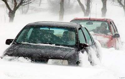
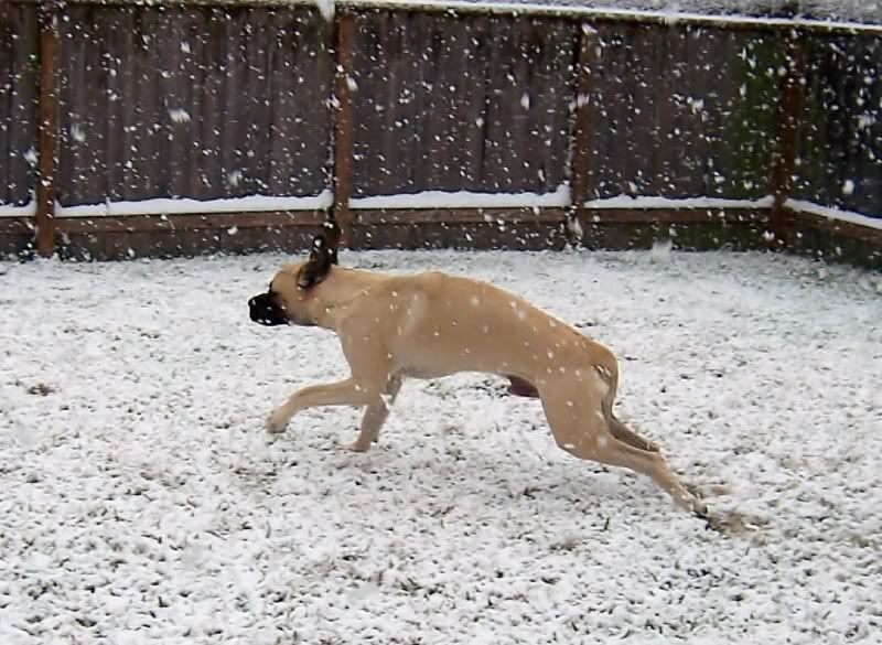
De eerste sneeuwvlokken in de V.S.
[ Bericht 2% gewijzigd door #ANONIEM op 09-10-2009 14:48:50 ]
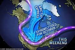
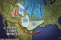
quote:A snowstorm will impact the lives of residents of the Rockies and Plains today into the weekend. Roadways will become treacherous, while there will be flight cancellations.
The coldest arctic air of the season yet is following the zone of snow falling across northern and central portions of the Rockies and Plains. The system dropping the snow and marking the leading edge of the brutally cold air is an Alberta Clipper.
Snowfall will generally be light to moderate, but will still cause very slippery roads with temperatures plummeting below freezing.
The heaviest snow will spread from southwestern Montana and northwestern Wyoming through central Nebraska today into tonight. From 3 to 6 inches of snow will blanket cities and towns within this corridor.
A much more widespread zone from the Rockies into southwestern Minnesota and western Iowa will have a fresh coating of 1-3 inches of snow by Saturday morning.
Following Denver's first flakes of snow Thursday, the city will likely receive its first accumulating snowfall of about an inch that will come down tonight into Saturday.
Motorists traveling across portions of interstates 25, 80, 90 and 94 will encounter dangerous winter driving conditions by late today into Saturday. Gusty winds will add to the dangers by blowing and drifting the snow.
Flights could also be delayed or canceled with the low visibility caused by the falling snow. Airline passengers traveling into or out of Billings, Mont., Cheyenne, Wyo., and North Platte, Neb. could be among those that experience these travel troubles.
Power outages will be less widespread than they were with last week's snowstorm in the northern Rockies and the northern High Plains. A few communities could still endure power outages where the heaviest snow weighs down trees and power lines.
Power outages will not only be a nuisance, but could be very dangerous for residents in this zone. Overnight, some very long-standing record lows may be shattered across parts of the Rockies and High Plains as temperatures plunge into the single digits and teens.
[ Bericht 2% gewijzigd door #ANONIEM op 09-10-2009 14:48:50 ]
tvp
Sinds juli in Texas, zomer was warm, maar begint inmiddels behoorlijk af te koelen, vandaag niet boven de 15 graden geweest. Gisteren was het nog wel 30. Ik heb alleen niet echt rekening met koude temperaturen gehouden, dus moet binnenkort maar eens gaan winkelen.
Vannacht kwam er trouwens een behoorlijk stormfront langs. Op de lokale buienradars stond dat er in het noorden en westen van Texas en in rond Oklahoma tornado's waren. Aangegeven met roze vakjes op wfaa.com. Ik dacht altijd dat die alleen in het voorjaar voorkwamen.

Zelfs in Texas kan het knap koud worden.quote:Op zaterdag 10 oktober 2009 02:50 schreef Schuifpui het volgende:
tvp
Sinds juli in Texas, zomer was warm, maar begint inmiddels behoorlijk af te koelen, vandaag niet boven de 15 graden geweest. Gisteren was het nog wel 30. Ik heb alleen niet echt rekening met koude temperaturen gehouden, dus moet binnenkort maar eens gaan winkelen.
Vannacht kwam er trouwens een behoorlijk stormfront langs. Op de lokale buienradars stond dat er in het noorden en westen van Texas en in rond Oklahoma tornado's waren. Aangegeven met roze vakjes op wfaa.com. Ik dacht altijd dat die alleen in het voorjaar voorkwamen.
De winter is begonnen in de Rocky Mountains met veel sneeuw en de kou dringt verder zuidelijk door.
De temperatuur zakt tot onder de -16 graden.
De temperatuur zakt tot onder de -16 graden.
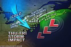
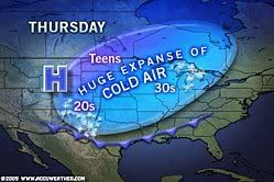
quote:Cold temperatures will persist across the Midwest today.
Snow will continue in parts of the Plains, spreading further north into the Dakotas later today and heading east through the Upper Mississippi Valley tonight and tomorrow.
The heaviest snow is expected in the Black Hills in western South Dakota where over six inches of new snow can be expected.
On the southern end of the precipitation area, rain is expected from the Central Plains through the Mid-Mississippi Valley and the lower Great Lakes through tomorrow night.
A new system is expected to take shape in the Plains Tuesday, bringing more rain and snow to the Plains States before heading east mid to late week.
Highs today will range from the 20s in western South Dakota to the 60s in the Ohio Valley.
Bizar eigenlijk... -9 en +29 in één land 
Maar ja, dan wel een bizar (groot) land
Yellowstone staat niet apart aangegeven.. met die bronnen daar maakt dat het niet warmer?
Maar ja, dan wel een bizar (groot) land
Yellowstone staat niet apart aangegeven.. met die bronnen daar maakt dat het niet warmer?
Video:quote:Skiër filmt crash door lawine
HAINES, ALASKA: Een skiër die zichzelf met een camera filmt in Haines, Alaska, is tijdens de afdaling gegrepen door een lawine.
De sneeuw sleurde hem 150 meter mee naar beneden, waarna hij werd bedolven onder een laag sneeuw. Tien minuten later werd hij uitgegraven van onder de sneeuw, terwijl de camera nog draaide. Wonder boven wonder heeft de skiër geen botbreuken aan zijn hachelijke avontuur overgehouden, maar wel wat ademhalingsproblemen
http://tf1.lci.fr/infos/i(...)-par-sa-camera-.html
Die heeft geluk gehad.quote:Op maandag 12 oktober 2009 09:39 schreef Frutsel het volgende:
[..]
Video:
http://tf1.lci.fr/infos/i(...)-par-sa-camera-.html
Hier een filmpje. Amerikanen moeten even wennen aan het invallen van de winter.
50-car pileup in first big snow
Het bizarre in de VS is meer dat dit in één week tijd op dezelfde plek kan gebeuren.quote:Op maandag 12 oktober 2009 09:33 schreef Frutsel het volgende:
Bizar eigenlijk... -9 en +29 in één land
Maar ja, dan wel een bizar (groot) land
Yellowstone staat niet apart aangegeven.. met die bronnen daar maakt dat het niet warmer?
Maar goed, zij hebben geen warme golfstroom..
25 graden celcius in Chicago met kerst, een week later vroor het een paar graden!quote:
[..]
Het bizarre in de VS is meer dat dit in één week tijd op dezelfde plek kan gebeuren.
Maar goed, zij hebben geen warme golfstroom..
Hetgeen bewezen en beklonken moest worden.
En in Kenya is er sneeuw en woestijn in 1 landjequote:
Bizar eigenlijk... -9 en +29 in één land
Maar ja, dan wel een bizar (groot) land
Yellowstone staat niet apart aangegeven.. met die bronnen daar maakt dat het niet warmer?
I am a Chinese college students, I have a loving father, but I can not help him, he needs to do heart bypass surgery, I can not help him, because the cost of 100,000 or so needed, please help me, lifelong You pray Thank you!
Ik heb een half jaar in Oklahoma gewoond. Smorgens was het daar 28 graden en smiddags draaide de wind van zuid naar noord en was het nog maar 10 graden met een ijzige wind.... Dit is de normaalste zaak van de wereld daar en je went er wel aan ..
Nooit windstil daar en de mega onweersbuien vliegen om je oren in April/Mei... tevens mogelijkheid om in September/Oktober flinke onweersbuien te krijgen! Geweldige staat voor de weerfreaks!
Nooit windstil daar en de mega onweersbuien vliegen om je oren in April/Mei... tevens mogelijkheid om in September/Oktober flinke onweersbuien te krijgen! Geweldige staat voor de weerfreaks!
Grootste temperatuurovergang was in Amerika. Spearfish South Dakota. De temperatuur ging in 2 minuten tijd van -20 naar +7,2 graden.
In 24 uur tijd was het ook in Amerika. In Browning Montana daalde de temperatuur van +6.7 naar - 48,8. Een verschil van 55 graden.

weerrecords
[ Bericht 5% gewijzigd door #ANONIEM op 13-10-2009 19:21:06 ]
In 24 uur tijd was het ook in Amerika. In Browning Montana daalde de temperatuur van +6.7 naar - 48,8. Een verschil van 55 graden.
weerrecords
[ Bericht 5% gewijzigd door #ANONIEM op 13-10-2009 19:21:06 ]

En dan worden wij met zijn allen ziek als het even een paar graden kouder is.quote:
Grootste temperatuurovergang was in Amerika. Spearfish South Dakota. De temperatuur ging in 2 minuten tijd van -20 naar +7,2 graden.
In 24 uur tijd was het ook in Amerika. In Browning Montana daalde de temperatuur van +6.7 naar - 48,8. Een verschil van 55 graden.
weerrecords
Ik woon aan Lake Michigan. Door de invloed van het water hebben wij een veel kouder en slechter klimaat dan +- 50km landinwaarts. Dit is mijn eerste winter in de USA maar het belooft een slechte te worden. Ik vul mijn kledingkast aan en ik ben benieuwd.
Het schommelt hier nu de hele dag rond het vriespunt met vervelend koude winden. Het meer is ook behoorlijk onstuimig.
Het schommelt hier nu de hele dag rond het vriespunt met vervelend koude winden. Het meer is ook behoorlijk onstuimig.
[b]Op vrijdag 24 augustus 2007 09:50 schreef PretKroket het volgende:[/b]
dude? :') ik hoop voor je dat je niet serieus bent
Even voor jou: 2x1/2 = 1/2 x 1/2
[b]Neem mij niet tè serieus, dat doe ik zelf ook niet[/b]
dude? :') ik hoop voor je dat je niet serieus bent
Even voor jou: 2x1/2 = 1/2 x 1/2
[b]Neem mij niet tè serieus, dat doe ik zelf ook niet[/b]
Texas morgen 29C.quote:Op dinsdag 13 oktober 2009 20:47 schreef Barcaconia het volgende:
Ik woon aan Lake Michigan. Door de invloed van het water hebben wij een veel kouder en slechter klimaat dan +- 50km landinwaarts. Dit is mijn eerste winter in de USA maar het belooft een slechte te worden. Ik vul mijn kledingkast aan en ik ben benieuwd.
Het schommelt hier nu de hele dag rond het vriespunt met vervelend koude winden. Het meer is ook behoorlijk onstuimig.
quote:
[b]Op vrijdag 24 augustus 2007 09:50 schreef PretKroket het volgende:[/b]
dude? :') ik hoop voor je dat je niet serieus bent
Even voor jou: 2x1/2 = 1/2 x 1/2
[b]Neem mij niet tè serieus, dat doe ik zelf ook niet[/b]
dude? :') ik hoop voor je dat je niet serieus bent
Even voor jou: 2x1/2 = 1/2 x 1/2
[b]Neem mij niet tè serieus, dat doe ik zelf ook niet[/b]
Je hebt daar ook het Lake effect. Depressies over het 'warmere water' van het meer levert dan veel sneeuw op.quote:Op dinsdag 13 oktober 2009 20:47 schreef Barcaconia het volgende:
Ik woon aan Lake Michigan. Door de invloed van het water hebben wij een veel kouder en slechter klimaat dan +- 50km landinwaarts. Dit is mijn eerste winter in de USA maar het belooft een slechte te worden. Ik vul mijn kledingkast aan en ik ben benieuwd.
Het schommelt hier nu de hele dag rond het vriespunt met vervelend koude winden. Het meer is ook behoorlijk onstuimig.
Ja klopt. Dat is mijn tenminste verteld. Ik heb het zelf nog nooit meegemaakt omdat ik hier pas net woon.
Ik woon letterlijk tegen het lake aan dus het weer is hier het ergst. Het kan hier behoorlijk sneeuwen terwijl ze in de eerste stad landinwaarts nog redelijk normaal weer hebben.
Ik woon letterlijk tegen het lake aan dus het weer is hier het ergst. Het kan hier behoorlijk sneeuwen terwijl ze in de eerste stad landinwaarts nog redelijk normaal weer hebben.
[b]Op vrijdag 24 augustus 2007 09:50 schreef PretKroket het volgende:[/b]
dude? :') ik hoop voor je dat je niet serieus bent
Even voor jou: 2x1/2 = 1/2 x 1/2
[b]Neem mij niet tè serieus, dat doe ik zelf ook niet[/b]
dude? :') ik hoop voor je dat je niet serieus bent
Even voor jou: 2x1/2 = 1/2 x 1/2
[b]Neem mij niet tè serieus, dat doe ik zelf ook niet[/b]
Het maakt toch ook nog uit of je ten westen of oosten van Lake Michigan woont?quote:Op dinsdag 13 oktober 2009 20:47 schreef Barcaconia het volgende:
Ik woon aan Lake Michigan. Door de invloed van het water hebben wij een veel kouder en slechter klimaat dan +- 50km landinwaarts. Dit is mijn eerste winter in de USA maar het belooft een slechte te worden. Ik vul mijn kledingkast aan en ik ben benieuwd.
Het schommelt hier nu de hele dag rond het vriespunt met vervelend koude winden. Het meer is ook behoorlijk onstuimig.
FOK! verstandig, lees een P.I.
Geen idee, ik woon ten oosten. In de staat Michigan dus.quote:Op woensdag 14 oktober 2009 13:39 schreef JohnnyKnoxville het volgende:
[..]
Het maakt toch ook nog uit of je ten westen of oosten van Lake Michigan woont?
[b]Op vrijdag 24 augustus 2007 09:50 schreef PretKroket het volgende:[/b]
dude? :') ik hoop voor je dat je niet serieus bent
Even voor jou: 2x1/2 = 1/2 x 1/2
[b]Neem mij niet tè serieus, dat doe ik zelf ook niet[/b]
dude? :') ik hoop voor je dat je niet serieus bent
Even voor jou: 2x1/2 = 1/2 x 1/2
[b]Neem mij niet tè serieus, dat doe ik zelf ook niet[/b]

Ah ja, ik sprak een tijdje terug iemand die in Holland, Michigan woont. Die had het letterlijk over "dumping". Inderdaad koude lucht over Lake Michigan die sneeuw aanvoert en alles dumpt in een strook van 20 km. langs het meer.quote:Op woensdag 14 oktober 2009 13:40 schreef Barcaconia het volgende:
Geen idee, ik woon ten oosten. In de staat Michigan dus.
FOK! verstandig, lees een P.I.
Klinkt leukquote:Op woensdag 14 oktober 2009 13:42 schreef JohnnyKnoxville het volgende:
[..]
Ah ja, ik sprak een tijdje terug iemand die in Holland, Michigan woont. Die had het letterlijk over "dumping". Inderdaad koude lucht over Lake Michigan die sneeuw aanvoert en alles dumpt in een strook van 20 km. langs het meer.
Ik woon niet ver van Holland af. Leuk stadje trouwens
[b]Op vrijdag 24 augustus 2007 09:50 schreef PretKroket het volgende:[/b]
dude? :') ik hoop voor je dat je niet serieus bent
Even voor jou: 2x1/2 = 1/2 x 1/2
[b]Neem mij niet tè serieus, dat doe ik zelf ook niet[/b]
dude? :') ik hoop voor je dat je niet serieus bent
Even voor jou: 2x1/2 = 1/2 x 1/2
[b]Neem mij niet tè serieus, dat doe ik zelf ook niet[/b]
Ik denk dat de meeste sneeuw ten oosten van de meren valt. De depressies komen meestal vanuit het noorden/westen.quote:Op woensdag 14 oktober 2009 13:39 schreef JohnnyKnoxville het volgende:
[..]
Het maakt toch ook nog uit of je ten westen of oosten van Lake Michigan woont?
Ik zal jullie met foto's op de hoogte houden als het begint.quote:
[..]
Ik denk dat de meeste sneeuw ten oosten van de meren valt. De depressies komen meestal vanuit het noorden/westen.
[b]Op vrijdag 24 augustus 2007 09:50 schreef PretKroket het volgende:[/b]
dude? :') ik hoop voor je dat je niet serieus bent
Even voor jou: 2x1/2 = 1/2 x 1/2
[b]Neem mij niet tè serieus, dat doe ik zelf ook niet[/b]
dude? :') ik hoop voor je dat je niet serieus bent
Even voor jou: 2x1/2 = 1/2 x 1/2
[b]Neem mij niet tè serieus, dat doe ik zelf ook niet[/b]

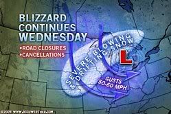
Sneeuw in Denver
quote:DENVER (AP) -- An early blast of winter walloped some western states with deep snow and slowly pushed into Nebraska and Kansas Thursday, bringing blizzard conditions to the eastern plains and causing treacherous roads, closed schools and hundreds of canceled flights.
The fall storm spread 3 feet of snow and left much higher drifts across parts of northern Utah, Wyoming and Colorado, before its leading edge hit neighboring states just to the east.
Wind-driven snow built to blizzard conditions over much of eastern Colorado. The weather service warned most area roads would be impassible Thursday night because of blowing snow and near-zero visibility.
The heaviest October snowfall in the Denver area in a decade forced the closure of hundreds of schools and businesses. Roads across the region remained snowpacked and icy.
"Big storms like these, they seem to come around every 10 to 12 years," said Kyle Fredin, a National Weather Service meteorologist.
Denver-based Frontier Airlines said it canceled 44 flights in and out of Denver International Airport. Other flights were delayed by up to four hours. United Airlines, the airport's dominant carrier with about 400 flights per day, canceled half its flights Thursday to prevent delays and cancelations from spilling over into Friday, spokesman Charlie Hobart said. Both airlines planned to operate full schedules Friday.
Airport spokesman Chuck Cannon said crews were using 174 pieces of snow-removal equipment to keep runways and taxiways clear as they dealt with severe wind gusts. Cannon said two departure and two arrival runways were open. The airport received at least 16 inches of snow with 5-foot snow drifts east of Denver, the weather service said.
The Colorado Department of Transportation closed a 140-mile stretch of Interstate 70 from near Denver to Burlington and 55 miles of Interstate 76 from Lochbuie to Fort Morgan. Plows struggled to keep up with the blowing snow, said CDOT spokesman Bob Wilson.
No serious accidents were reported, likely because shuttered businesses meant fewer cars on the road, Wilson said.
In Wyoming, road closures included a 40-mile stretch of Interstate 80 from Cheyenne to Laramie; a 35-mile span of Interstate I-25 from Wellington to Cheyenne; and a 200-mile stretch of I-80 west of Big Springs to Laramie, Wyo. Snow drifts were running up to 4 feet in Cheyenne and up to 6 feet 30 miles north of the city.
Hmm Denver, daar ben ik over 2 maanden. Hopelijk dan wat beter weer daar. Wij moeten ook over de I70 en vliegen met Frontier van en naar Denver.quote:
Video van rtl
Video van The Weather Channel
[ Bericht 44% gewijzigd door #ANONIEM op 01-11-2009 13:46:45 ]
Video van The Weather Channel
[ Bericht 44% gewijzigd door #ANONIEM op 01-11-2009 13:46:45 ]

quote:The first big snowstorm of the season hit Colorado in the last week of October 2009. Hundreds of flights were cancelled at Denver International Airport, and interstate highways leading from Denver to Kansas, Nebraska, and Wyoming were closed due to blizzard conditions. Some locations in Colorado, Utah, and Wyoming received several feet of snow.
Sunny skies on October 31, 2009, allowed the Moderate Resolution Imaging Spectroradiometer (MODIS) on NASA’s Aqua satellite to capture this view of the whitened landscape. Snow highlights the rugged mountains as well as the urban and agricultural landscapes of the plains. Denver appears as a grayish patch near image center, and a broad swath of snow sweeps eastward to the Kansas state line. The patchwork of fields and pastures that dominates the Colorado plains is most obvious around the margins of the snowy areas.
Lake snow effect
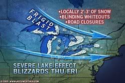
quote:Another premature blast of winter is right around the corner for the Northeast with frigid winds for many and even some snow for a few.
Cold air will arrive tonight into Friday, in the wake of chilly rain and even sleet and snow running across Upstate New York and northern New England.
A storm will strengthen off the Northeast coast Thursday night into Friday.
The brunt of the potent storm will slam Down East Maine and Atlantic Canada.
On the front side of the storm, winds over eastern New England could be strong enough to cause tree damage and power outages.
Gusty winds blowing on the storm's back side Thursday over the Great Lakes will spread through the mid-Atlantic by Friday. Gusts could top 50 mph in some areas; strong enough to cause sporadic power outages once again.
AccuWeather.com RealFeel® temperatures will drop into the teens and 20s throughout the Northeast Thursday night.
Winter attire is recommended for those venturing out, even in Boston, New York City, Philadelphia, Baltimore and Washington, D.C.
Enough cold air will arrive that snow also falls across parts of the Northeast Thursday night into Friday.
A coating to an inch of snow Thursday night could create slippery roads in the mountains of northern Pennsylvania, New York and central New England.
Only a few wet snowflakes will make an appearance in the northern and western suburbs of New York City.

Ik ben benieuwd. Michigan staat nog niet op die lijst dus misschien ontspringen we de dans.
[b]Op vrijdag 24 augustus 2007 09:50 schreef PretKroket het volgende:[/b]
dude? :') ik hoop voor je dat je niet serieus bent
Even voor jou: 2x1/2 = 1/2 x 1/2
[b]Neem mij niet tè serieus, dat doe ik zelf ook niet[/b]
dude? :') ik hoop voor je dat je niet serieus bent
Even voor jou: 2x1/2 = 1/2 x 1/2
[b]Neem mij niet tè serieus, dat doe ik zelf ook niet[/b]
Kickje!
Vanavond aan de turkey, maar hoe staat het ervoor met de winter in de VS? Hier in Texas is het overdag nog rond de 20 graden, 's nachts zo'n 4 graden de afgelopen dagen. Ik heb ook al vorst gezien op autoruiten, daken en gras. Eigenlijk voelt het behoorlijk koud aan. Vandaag voor het eerst de verwarming aangezet, huizen zijn toch wel iets minder geïsoleerd dan in Nederland, het was net maar 13C binnen.
Vanavond aan de turkey, maar hoe staat het ervoor met de winter in de VS? Hier in Texas is het overdag nog rond de 20 graden, 's nachts zo'n 4 graden de afgelopen dagen. Ik heb ook al vorst gezien op autoruiten, daken en gras. Eigenlijk voelt het behoorlijk koud aan. Vandaag voor het eerst de verwarming aangezet, huizen zijn toch wel iets minder geïsoleerd dan in Nederland, het was net maar 13C binnen.
Vannacht, ik ben net thuis van Thanksgiving dinner, heb ik de eerste hagelbui gehad. Morgen ligt er waarschijnlijk sneeuw volgens het weerbericht (Michigan).
[b]Op vrijdag 24 augustus 2007 09:50 schreef PretKroket het volgende:[/b]
dude? :') ik hoop voor je dat je niet serieus bent
Even voor jou: 2x1/2 = 1/2 x 1/2
[b]Neem mij niet tè serieus, dat doe ik zelf ook niet[/b]
dude? :') ik hoop voor je dat je niet serieus bent
Even voor jou: 2x1/2 = 1/2 x 1/2
[b]Neem mij niet tè serieus, dat doe ik zelf ook niet[/b]
Het sneeuwt in Texas! Ik heb ook niet echt veel warme kleding mee.
Komende dagen wordt het kouder en vrijdag verwachten ze droge sneeuw. Toch niet echt verwacht toen ik 5 maanden geleden m'n koffers pakte om vanuit Nederland hier naar toe te komen.quote:... SIGNIFICANT WEATHER ADVISORY...
MODERATE SNOW IS OCCURRING ACROSS THE REGION AND WILL CONTINUE THROUGH THE MID MORNING HOURS. ACCUMULATION OF 1 TO 2 INCHES ON ELEVATED OR GRASSY SURFACES WILL BE POSSIBLE. SOME SNOW ACCUMULATIONS ON ROADWAYS IS POSSIBLE... WHICH MAY IMPACT TRAVEL THIS MORNING. ALTHOUGH ROAD SURFACES ARE STILL WARM AND MUCH OF THE SNOW IS MELTING... MOTORISTS SHOULD EXERCISE CAUTION WHEN TRAVELING THIS MORNING. CONDITIONS WILL IMPROVE DURING THE MID MORNING HOURS AS TEMPERATURES WARM.
quote:Soon after people in the Northeast deal with heavy rain, delays and flooding problems from a storm Wednesday into Thursday, the track of a second and colder storm this weekend could bring snowfall to a heavily populated area in the mid-Atlantic.
It may be time to locate your snow brush and snow shovel if you live in the corridor from Roanoke to Philadelphia
Forecast problems still remain with a second storm forecast to bring heavy snow to the Houston, Texas, area Friday.
For now, the most likely area to receive several inches of snow lies from southwestern Virginia to southern New Jersey.
Computer models have trended farther south and east over the past 24 hours, and this trend will have to be watched for any more shifts in that direction or the reverse.
A difference in storm track by as little as 100 miles could mean no snow at all and the band of heavy snow falling somewhere else.
One thing to keep in mind is just because heavy rain falls with the first storm Wednesday into Thursday that does not mean the second storm this weekend will do the same.
Additionally, in the wake of the rainstorm and the potential snowstorm, lake-effect snow can bring bands of heavy snowfall to the lee of lakes Erie and Ontario later Thursday into Friday and again Saturday night into Sunday.
More storms and cold outbreaks will follow as the "December to remember" is just getting underway.
Ik heb de eerste sneeuw gezien maar nog niet veel. Het is nog behoorlijk warm en mild voor de tijd van het jaar.
[b]Op vrijdag 24 augustus 2007 09:50 schreef PretKroket het volgende:[/b]
dude? :') ik hoop voor je dat je niet serieus bent
Even voor jou: 2x1/2 = 1/2 x 1/2
[b]Neem mij niet tè serieus, dat doe ik zelf ook niet[/b]
dude? :') ik hoop voor je dat je niet serieus bent
Even voor jou: 2x1/2 = 1/2 x 1/2
[b]Neem mij niet tè serieus, dat doe ik zelf ook niet[/b]
Imponerende kou in VS
Niet alleen wij kijken uit naar de sneeuw.
In Amerika zijn alle ogen dit weekend gericht op het zuiden van het land. In de stad Houston, Texas, is vandaag de vroegste sneeuwdag genoteerd in de geschiedenis van de stad. Niet voor te stellen als je weet dat deze regio zich normaal druk maakt over orkanen en andere tropische overlast. Ook elders in de VS is het koud. Tot aan de grens met Mexico vriest het ook overdag.
Kou verscherpt zich
De komende dagen wordt het nog een stuk kouder.
Eerst neemt de kou in het zuiden wat af, maar ten zuiden van Alaska ontstaat op dit moment een krachtig hogedrukgebied. Aan de oostflank hiervan wordt vanuit Canada de komende dagen échte diepvrieskou op transport gezet naar het zuiden. Dan hebben we het over middagtemperaturen die niet boven -10 graden uitkomen. In een groot deel van Canada blijft het volgende week overdag gewoon meer dan 20 graden vriezen. Hieronder het GFS-ensemble voor de Canadese stad Edmonton. Het toont de temperatuur op zo’n 1500m hoogte, de rode lijn laat de normale temperatuur zien.
De kou trekt vervolgens naar het oosten waar een actieve depressie uiteindelijk voor een winters feestje kan gaan zorgen. Naast de kou moet de omgeving rond New York en Washington in de loop van de week namelijk rekening houden met een dik pak sneeuw. Saillant detail is dat Houston tegen die tijd alweer met 20 graden van de zon kan genieten. (wintersport.nl)
quote:
Het sneeuwt in Texas!
[..]
Komende dagen wordt het kouder en vrijdag verwachten ze droge sneeuw. Toch niet echt verwacht toen ik 5 maanden geleden m'n koffers pakte om vanuit Nederland hier naar toe te komen.
Hetgeen bewezen en beklonken moest worden.

De winter lijkt definitief te zijn ingevallen. Flinke sneeuw in een groot deel van de VS. De sneeuw in DFW, Texas vrijdag is uitgebleven. Vanmiddag wel een paar natte sneeuwvlokken gehad nog. Morgen weer 16 graden, daarna iets kouder.
Over twee weken vertrekken we op roadtrip, eerst Colorado, dan Arizona en Utah, vervolgens Nevada en dan California. Hoop dat er niet al te veel sneeuw valt onderweg.
Ik ben nu in Iowa en morgen in Minnesota, precies in het rode gebied waar een blizzardwarning is. Ik hoorde op het nieuws dat ze 10" sneeuw verwachten. Ik ben benieuwd.
[b]Op vrijdag 24 augustus 2007 09:50 schreef PretKroket het volgende:[/b]
dude? :') ik hoop voor je dat je niet serieus bent
Even voor jou: 2x1/2 = 1/2 x 1/2
[b]Neem mij niet tè serieus, dat doe ik zelf ook niet[/b]
dude? :') ik hoop voor je dat je niet serieus bent
Even voor jou: 2x1/2 = 1/2 x 1/2
[b]Neem mij niet tè serieus, dat doe ik zelf ook niet[/b]

quote:Frigid air driven by 40- to 60-mph wind gusts will spread snow and falling temperatures farther to the east over the Midwest into tonight, leading to deteriorating travel conditions, including a freeze-up on roads and sidewalks.
While travel conditions improve over the southern Plains, conditions are getting worse farther northeast over the Upper Midwest as cold air is being pulled in by strong winds.
Temperatures are falling below freezing in Chicagoland as a burst of snow rolls through. Roads may quickly turn slushy and snow covered in some areas where rain washed away the previous snow or places where the snow was cleared.
These same conditions will roll into Detroit, Indianapolis and Cleveland into this evening.
Winds gusts up to 60 mph will continue to shift eastward through the Ohio Valley into tonight and can lead to power outages, downed trees and minor property damage.
Some arriving flights at the Minneapolis-St. Paul International Airport are being delayed by several hours due to high winds and blowing snow.
Drifts of up to 4 feet are piling up on the storm's back side as powerful winds push powdery snow around. The blowing snow is leading to low visibility at times, even after snow stops falling from the clouds.
Cities subject to the blowing and drifting snow include Omaha, Des Moines and La Crosse, Wis.
Officials are currently advising motorists not to travel on interstates 29, 35 and 80 through Iowa. A similar statement could be made to travelers across neighboring states and Michigan.
Ik zat er midden inquote:
[b]Op vrijdag 24 augustus 2007 09:50 schreef PretKroket het volgende:[/b]
dude? :') ik hoop voor je dat je niet serieus bent
Even voor jou: 2x1/2 = 1/2 x 1/2
[b]Neem mij niet tè serieus, dat doe ik zelf ook niet[/b]
dude? :') ik hoop voor je dat je niet serieus bent
Even voor jou: 2x1/2 = 1/2 x 1/2
[b]Neem mij niet tè serieus, dat doe ik zelf ook niet[/b]

quote:A severe winter storm blustered its way across the United States on December 7 and 8, 2009. The storm dumped heavy snow from California to the Great Plains, and fierce winds added to the hazardous conditions. The storm was predicted to continue eastward in midweek, and blizzard warnings were in effect for Great Lakes states as of December 9.
rest van het artikel
Inorbit: zeg dat dan typluie triangeljosti
Beauregard: Een beetje FOK!ker laat het brood door z'n moeder smeren.
Ecosia
ek's 'n flash drive, jy's 'n floppy
Beauregard: Een beetje FOK!ker laat het brood door z'n moeder smeren.
Ecosia
ek's 'n flash drive, jy's 'n floppy

Hopelijk eind volgende week ook in ons land van die winterse taferelen. Weliswaar zonder slachtoffers danquote:DES MOINES, Iowa — A gigantic storm dumped more than a foot of snow across much of the Midwest and New England as it marched eastward Wednesday, creating blizzard conditions, burying cars under huge drifts and providing ammunition for a massive campus snowball fight in Wisconsin.
Even more snow fell in some areas, with 16 inches reported in Des Moines and nearly 19 inches just south of Madison, Wis. Gusts of up to 50 mph created snow drifts between 8 and 15 feet tall and even knocked down a two-story Christmas tree in downtown Champaign, Ill.
The storm was blamed for at least 16 deaths, most in traffic accidents. Hundreds of schools canceled classes, power was knocked out to thousands of people from Missouri to New York and hundreds of flights were canceled.
In the Twin Cities, where about 6 inches of snow fell and the wind chill dipped to minus 9 degrees, Kent Barnard eased a massive orange snowplow into traffic in the suburb of Arden Hills on Wednesday morning. He dropped the right wing of the plow down onto the shoulder, making a grinding sound as the wing sent out a spray of snow.
"You gotta watch it because some people try to sneak up around you," Barnard said. "They'll see that big orange flashing truck coming and go, 'I don't want to get caught behind that thing."'
Rest of story: click here
Hollanders kennende zal er wel weer een heel leger dode lease rijders te betreuren zijnquote:Op donderdag 10 december 2009 14:54 schreef Frutsel het volgende:
[ afbeelding ]
[..]
Hopelijk eind volgende week ook in ons land van die winterse taferelen. Weliswaar zonder slachtoffers dan
Inorbit: zeg dat dan typluie triangeljosti
Beauregard: Een beetje FOK!ker laat het brood door z'n moeder smeren.
Ecosia
ek's 'n flash drive, jy's 'n floppy
Beauregard: Een beetje FOK!ker laat het brood door z'n moeder smeren.
Ecosia
ek's 'n flash drive, jy's 'n floppy
Nog meer sneeuw onderweg, dankzij het lake effect.
[ Bericht 3% gewijzigd door #ANONIEM op 10-12-2009 20:27:26 ]
quote:Crippling Lake-Effect Snow Event Underway
In the wake of the fierce coast-to-coast storm, blustery winds have greatly activated the lake-effect snow machine across the Great Lakes. Towns and cities will become crippled by the snow, which will persist through at least Friday and will need to be measured with a yardstick.
The Northeast Regional Radar shows the beginning stages of this extremely significant lake-effect snow
Between 1 to 3 feet of snow will bury places to the lee of lakes Superior, Erie and Ontario, as well as Georgian Bay through at least Friday. It is not out of the question that the snow will amount to 4 feet.
Snowfall rates may reach a couple of inches per hour within the most intense bands throughout the Great Lakes. Road crews will likely have trouble keeping streets and highways clear.
Blustery winds will not only make measuring the snow difficult, but will add to the severity of the situation.
Localized whiteouts will result as the winds severely whip the snow around. Drifting snow may make some roads impassible.
Motorists should prepare for treacherous travel and potential road closures on the New York State Thruway (I-90) through southwestern New York, I-81 in upstate New York, I-196 and I-94 in southeastern Michigan.
An end to this intense lake-effect snow event will finally come Friday night into Saturday as the snow tapers off from west to east.
[ Bericht 3% gewijzigd door #ANONIEM op 10-12-2009 20:27:26 ]
quote:In het centrum van de Verenigde Staten zijn woensdagnacht en donderdagochtend zestien mensen om het leven gekomen bij ongevallen die het gevolg waren van hevige sneeuwstormen. Dat melden verschillende media. Er wordt de komende dagen overigens nog meer sneeuw verwacht.
Slachtoffers
De meeste slachtoffers vielen bij verkeersongevallen. In delen van het Midwesten viel tot één meter sneeuw, waardoor de meeste scholen, universiteiten en openbare gebouwen gesloten moesten worden. Verschillende luchthavens moesten eveneens de deuren sluiten, en er worden ontzettend lange files waargenomen.
Krachtige sneeuwstorm
Dergelijke stormen zijn tijdens deze periode van het jaar niet ongewoon in dat deel van de VS. Een meteorologe van de National Weather Service, Penny Zabel, zei aan The New York Times dat het een bijzonder krachtige sneeuwstorm betreft.
Overstromingen
In het zuiden van het land zorgde de storm eveneens voor regen en overstromingen. (belga/vbd)
hln