WKN Weer, Klimaat en Natuurrampen
Lees alles over het onstuimige weer op onze planeet, volg orkanen en tornado's, zie hoe vulkanen uitbarsten en hoe Moeder Aarde beeft bij een aardbeving. Alles over de verwoestende kracht van onze planeet en tal van andere natuurverschijnselen.


Hier het tweede deel van Hurricane Season 2009 voor alle tropische stormen ter wereld. Voor zowel Atlantische, Indische als Pacifische stormen kan je hier terecht
Algemene Info
Met de term 'Hurricane Season' bedoelden we in eerste instante de periode van 1 juni tot 30 november.
Deze periode wordt in het Atlantische basin en de Golf van Mexico gezien als het Stormen-seizoen. Echter komen deze geweldadige stormen overal in de wereld voor en met name in Azië zorgen ze jaarlijks voor duizenden slachtoffers en tienduizenden daklozen. Echter horen we vaak erg weinig over de stormen in Azië en juist meer over die in de VS.
In de laatste jaren zijn Tropische Stormen meer en meer in de media gekomen. Het lijkt ook alsof ze meer en meer slachtoffers maken. Een documentaire over Hurricane Andrew uit 1992, heeft diepe indruk gemaakt en ook zullen kenners orkanen Floyd, Gilbert, Stan en Ivan zich zeker nog herinneren. De catastrofe die "Katrina" met zich meebracht ging de hele wereld over. En dan praten we eigenlijk alleen over de Atlantische stormen en lijken we te vergeten dat er in 2007 meer dan 4000 doden vielen in Bangladesh door orkaan Sidr en orkaan Nargis zorgde voor 80.000 doden in Myanmar alleen al.
Hoewel het Atlantische seizoen pas officieel in juni begint zijn er op andere plekken in de wereld zeker meer orkanen te vinden in de komende maanden. We zullen ook deze dus zeker gaan bespreken. Waarschijnlijk zal de kern van de discussie en de posts gaan over de periode 1-6-2008 t/m 30-11-2008. T.z.t. zal er ook wel een NWS-topic worden geopend als een orkaan ook uitgebreid in het nieuws komt.
Orkanen: Hoe ontstaan ze eigenlijk?
op de site van Wikipedia kan je in het Nederlands nalezen hoe ze ontstaan en wat de belangrijkste energiebron is voor hun verwoestende kracht: het warme zeewater
Ook de BBC heeft er een interessante en leuke animatie over gemaakt.
Ook wordt er op LiveScience in het engels prima uitgelegd hoe ze ontstaan en zich ontwikkelen
Indeling en Kracht
De stormen worden ingedeeld op 'categorie'. Vaak zijn het eerst tropische stormen" (Tropical Depression, Tropical Storms), die overgaan op Orkaanstatus (Hurricane/Tyfoons) Ze worden ingedeeld op windsnelheden via de Saffir-Simpson Schaal
Tropical Depression 24-38 mph winds (38-61 km/u)
Tropical Storm 39-73 mph winds (62-118 km/u)
Hurricane Categorie 1 74-95 mph winds (119-153 km/u) -- 4/5 ft Storm Surge -- Vb. Danny 1997, Stan 2005
Hurricane Categorie 2 96-110 mph winds (154-177 km/u) - 6/8 ft Storm Surge -- Vb. Danielle 2004
Hurricane Categorie 3 111-130 mph winds (178-209 km/u) - 9/12 ft Storm Surge - Vb.Fran 1996, Beta 2005
Hurricane Categorie 4 131-155 mph winds (210-249 km/u) - 13/18 ft Storm Surge - Vb.Hugo 1989, Frances 2004
Hurricane Categorie 5 > 156 mph winds (meer dan 250 km/u) -- 18ft or more S.S. -- Vb.Andrew 1992, Mitch 1998 en Wilma, Katrina 2005
TIP: Interactief (film0overzicht van de krachten van orkanen nav de schaal van Simpson
Waarom hebben orkanen namen?
De Tropische Depressies worden overal ter wereld in de gaten gehouden en zodra de depressies uitgroeien tot orkaan of cycloon, wordt er een naam aan de storm gegeven. Sinds 1950 krijgen ze namen op alfabetische volgorde (met uitzondering van de letters Q, U, X, Y en Z). Mocht een orkaan vernietigend hebben huisgehouden zoals Floyd, Gilbert en bijv. Katrina, dan zal die naam worden vervangen. Soms komt het ook voor dat alle letters van het alfabet gebruikt zijn in één seizoen (zoals 2005), dan zal een volgende storm Alpha gaan heten, gevolgd door Beta etc etc. Voor het orkanenseizoen 2009 zijn de namen als volgt:
Atlantische Stormen 2009
Ana, Bill, Claudette, Danny, Erika, Fred, Grace, Henri, Ida, Joaquin, Kate, Larry, Mindy, Nicholas, Odette, Peter, Rose, Sam, Teresa, Victor, Wanda
In het Noordoosten van de pacific ontstaan ook orkanen. Deze zorgen meestal voor weinig schade aan de Amerikaanse/Mexicaanse westkust.
Oost Pacifische Stormen 2009
Andres, Blanca, Carlos, Dolores, Enrique, Felicia, Guillermo, Hilda, Ignacio, Jimena, Kevin, Linda, Marty, Nora, Olaf, Patricia, Rick, Sandra, Terry, Vivian, Waldo, Xina, York, Zelda
Verder zijn er dan nog de stormen in het Noorden, Zuiden en Westen van de Pacific. Daar worden ze tyfoons en/of cyclonen genoemd. Met name de stormen in het Noord/Westen komen vaak in het nieuws omdat ze Japan, de Filipijnen, Taiwan en China vaak teisteren, maar ook geheel Zuid Oost Azie kunnen treffen. Meer informatie over de namen van deze stormenvind je hier.
Leuk hoor, maar wanneer zijn die orkaanseizoenen nou precies?
ATLANTISCHE OCEAAN: 1 juni t/m 30 november
NOORD OOST PACIFIC:Begin mei t/m begin November, met piek in Augustus/September
NOORD WEST PACIFIC: Begin juli t/m eind November, maar eigenlijk hele jaar door aktiviteit.
NOORD INDISCHE OCEAAN: April t/m December met pieken in Mei en November
ZUID INDISCHE + WEST AUSTRALISCHE OCEAAN: Oktober t/m Mei met pieken in Februari en April
ZUID WEST PACIFIC + OOST AUSTRALISCHE OCEAAN: Oktober tot eind April met piek in Februari.
Over het algemeen is Mei de rustigste maand en September de zwaarste.
Ennuh, hoe ziet die voorspelling er voor 2009 dan uit?
50 jaar Hurricane Seizoen hebben een gemiddeld orkaanseizoen gecreëerd. 9,6 stormen krijgen een naam, 5,9 stormen groeien uit tot orkaan en 2,3 orkanen worden superorkanen.(cat 4/5)
Volgens Phil Klotzbach en William Gray van CSU wordt 2009 een relatief druk orkaanseizoen. Volgens hun is er 63 procent kans dat een superorkaan in 2009 de VS kust zal treffen. Meer over de voorspelling voor 2009 en die van 2008 kan je hier lezen
Oude Delen
2004 - Deel 1 en Deel 2
2005 - Deel 1 en Deel 2
2006 - Deel 1 en Deel 2
2007 - Deel 1, Deel 2, Deel 3 en Deel 4
2008 - Deel 1 en Deel 2
2009 - Deel 1
Enkele Links
1. National Hurricane Centre
2. Carribean Storm Network
3. Hurricanezone
4. Hurricane Track
5. Website met satelietbeelden van de Caribbean en de rest van Amerika
6. Intellicast: Geavanceerde satellietfoto's en gifs van aktuele stormen
7. Tropical Weather Underground
8. Tropical Storm Risico's van dit moment
9. Wikipedia Hurricanes/Tyfonen in het algemeen
10. Alle stormen ter wereld van de laatste jaren in overzicht
11. The StormTrack
12. Orkanensite in de Filipijnen
13. Atlantische Orkanensite
14. Actuele orkanen in Australië en De orkaanindeling in Australië
15. Tropische weersite omgeving Australië
16. Mooie site over Orkanen aan de VS kusten
17. Website van NASA over Hurricanes
Opmerkelijke Wikipedia-Links
-- Hurricane Katrina 2005
-- Cyclone Nargis 2008
-- Hurricane Season 2008 - Wikipedia
-- Hurricane Season 2007 - Wikipedia
-- Hurricane Season 2006 - Wikipedia
-- Hurricane Season 2005 - Wikipedia
-- Hurricane Season 2004 - Wikipedia
Actuele Weerradar in Golf van Mexico

Actuele Water temperatuur.
=====================
Post hier je gegevens, berichten, data en opmerkelijke zaken over Orkanen, Tyfoons en Hurricanes en van 2009
[ Bericht 0% gewijzigd door Co_OL op 15-09-2009 08:09:29 ]

arme eilandbewoners 
quote:Microwave imagery from NASA's Aqua satellite revealed extremely high thunderstorms in Typhoon Choi-Wan as it began passing the island of Sai-Pan in the Western Pacific Ocean. The U.S. National Weather Service has already issued a tropical storm warning and a typhoon watch for Tinian, Saipan and Agrihan in the Northern Mariana Islands.
Saipan is the largest island and capital of the U.S. Commonwealth of the Northern Mariana Islands. The Northern Marianas are a chain of 15 tropical islands belonging to the Marianas archipelago in the western Pacific Ocean. In the year 2000, the island chain was home to more than 62,000 residents. The National Weather Service issues advisories for them, because they are a U.S. Commonwealth.
NASA satellite imagery showed that the tops of the thunderstorms are so high they reached the tropopause, the level of atmosphere between the troposphere and stratosphere. Those high thunderstorms mean very heavy rainfall for the area underneath. The cloud tops extended to the 200 millibar level in the atmosphere where temperatures are as cold or colder than -63 Fahrenheit.
Microwave images are created when data from NASA's Aqua satellite Atmospheric Infrared Sounder (AIRS) and Advanced Microwave Sounding Unit (AMSU) instruments are combined. These microwave images indicate where there is precipitation or ice in the cloud tops and the latest microwave image revealed Choi-Wan had cold, high thunderstorms.
On August 14 at 11 a.m. EDT, Choi-Wan was located 105 miles east-northeast of Saipan, near 16.2 north and 147.3 east. It was moving northwest near 5 mph. The storm has intensified over the last six hours in an area with warm waters and low wind shear. Choi-Wan's maximum sustained winds were near 90 mph and those winds were kicking up very high waves, as high as 29 feet. The typhoon is expected to pass north of Saipan Tuesday morning.
Residents of Saipan is already experiencing gusty winds and rains as the Choi-Wan passes to the northeast, and dangerous surf is expected along the shorelines. For a look at local radar from Andersen Air Force Base, Guam: http://radar.weather.gov/radar.php?rid=GUA&product=NCR&overlay=11101111&loop=yes
Storm surge and inundation of 3 to 5 feet above high tide is possible as Choi-Wan passes with hazardous surf of 8 to 12 feet along west facing reefs this evening...building to 13 to 16 feet tonight. High tide is expected around 6 p.m. local time on Tuesday.
The National Weather Service also expects locally heavy rainfall through early Wednesday Morning with totals of 3 to 5 inches on Tinian and Saipan and as much as 6 to 10 inches possible on Agrihan and Alamagan.
The National Weather Service issued a special bulletin at 10:09 p.m. local time (CHST) today, September 14: "The 24 hour pressure fall at Saipan airport was 7.5 millibars. Pressure falls are likely even larger at islands north of Saipan. This shows not only the continuing approach of Choi-Wan but also its continuing trend for intensification. It has been several years since a significant typhoon has struck the Marianas. Especially for Alamagan...beware of a sudden drop in winds. This may be the eye rather than the end of the storm. In this case winds will return just as suddenly from the opposite direction. Choi-wan will pass very close to Alamagan Tuesday afternoon."
Choi-Wan is the fifteenth tropical cyclone in the western Pacific Ocean this season. The sixteenth, Tropical Storm Koppu is poised to make landfall in China in the next day or two.


Tropical Storm Koppu was nearing landfall over southern China when the Moderate Resolution Imaging Spectroradiometer (MODIS) on NASA’s Terra captured this image on September 14, 2009. A thick disk of clouds, embedded with thunderstorms, arcs across the South China Sea. North of the storm, the spiraling bands of clouds appear to be disrupted by interaction with land.


Het oog is ook goed te zien. Monsterlijke storm inderdaad.
Super Typhoon Choi-wan had just become a monstrous Category 4 super typhoon on the morning of September 15, 2009, when the Moderate Resolution Imaging Spectroradiometer (MODIS) on NASA’s Terra satellite captured this photo-like image. Choi-wan is a perfect circle with bands of clouds pin-wheeling around the dense center. The dark blue surface of the Pacific Ocean is visible through the clear eye, which is defined by a towering wall of clouds.
At the time the image was taken, Choi-wan had sustained winds estimated at 230 kilometers per hour (145 miles per hour or 125 knots), according to the Joint Typhoon Warning Center. Choi-wan was strengthening. Twenty-four hours later, the storm reached Category 5 status with sustained winds of 260 km/hr (160 mph or 140 knots). The Joint Typhoon Warning Center expected the storm to intensify a little more.
While the storm raked across the Northern Mariana Islands and was targeting the small islands of Iwo To and Chinchi Jima, it was not forecast to hit any major land mass. In this image, Super Typhoon Choi-wan is centered over the northern arc of the Mariana Islands in the western Pacific Ocean, with the larger islands of Guam, Saipan, and Tinian located on the southern edge of the storm. The islands north of Saipan are volcanic and are either unoccupied or sparsely populated.


Super Typhoon Choi-wan had just become a Category 4 super typhoon on the morning of September 15, 2009, when the Moderate Resolution Imaging Spectroradiometer (MODIS) on NASA’s Aqua satellite captured the top image. Approximately a minute later, the CloudSat satellite also flew over the storm system. Cloudsat’s flight path (a section of which is shown as a grey line across the MODIS image) took it just north of the eye at the center of the storm.
At the time the images were taken, Choi-wan had sustained winds estimated at 240 kilometers per hour (150 miles per hour or 130 knots), according to the Joint Typhoon Warning Center. Choi-wan was strengthening. Less than twenty-four hours later, the storm reached Category 5 status with sustained winds of 260 km/hr (160 mph or 140 knots), a strength it maintained for a day before weakening to Category 4 strength on September 17. The images reflect the extreme power of the storm. In the top photo-like image, Choi-wan is formidable-looking, with tightly spiraling bands of clouds and a distinct eye.
The lower image provides a vertical profile of the storm. The satellite’s radar recorded the cloud structure, capturing a vertical cross section view of the storm. The dense clouds at the center of the storm tower above fifteen kilometers. Most distinctive is the eye, which is completely clear to sea level. The clouds on either side of the eye are dense, sending a strong radar signal back to the satellite as indicated by the dark blue color.
Like a ground-based weather radar instrument, Cloudsat sees storm structure by bouncing pulses of energy off cloud particles and recording the strength of the echo. The radar picture gives an idea of the shape and height of the clouds you would have seen if you could have sliced away the eastern half of the storm and looked in at it from the side. Dense clouds will return a stronger echo, and higher clouds will return an echo more quickly. Cloudsat sees tiny particles of ice and water within clouds. It is 1,000 times more sensitive than ground-based weather radar instruments, which measure large drops of water (rain) within clouds.

fuck fuck fuck, nog 2 weken en ik ga náár de Phillipijnen
Inorbit: zeg dat dan typluie triangeljosti
Beauregard: Een beetje FOK!ker laat het brood door z'n moeder smeren.
Ecosia
ek's 'n flash drive, jy's 'n floppy
Beauregard: Een beetje FOK!ker laat het brood door z'n moeder smeren.
Ecosia
ek's 'n flash drive, jy's 'n floppy

Nou, maak er maar een opbouwmissie van danquote:Op maandag 28 september 2009 09:46 schreef Jumparound het volgende:
fuck fuck fuck, nog 2 weken en ik ga náár de Phillipijnen
ja idd... 
Inorbit: zeg dat dan typluie triangeljosti
Beauregard: Een beetje FOK!ker laat het brood door z'n moeder smeren.
Ecosia
ek's 'n flash drive, jy's 'n floppy
Beauregard: Een beetje FOK!ker laat het brood door z'n moeder smeren.
Ecosia
ek's 'n flash drive, jy's 'n floppy
quote:Tyfoon Ketsana op weg naar Vietnam
Tropische storm Ketsana, die afgelopen weekend voor grote overstromingen zorgde op de Filipijnen, is aangesterkt tot een tyfoon. Dinsdag zal de nog wat aansterkende storm de Vietnamese kust bereiken in de buurt van Hue.
Ketsana heeft inmiddels zeker 140 mensenlevens gekost op de Filipijnen. In de hoofdstad Manilla stond het water hier en daar zes meter hoog na de overvloedige regenval (er werd 455 mm in 24 uur afgetapt). Bijna een half miljoen mensen hebben hun huizen moeten verlaten.
Hoewel de Filipijnen wel gewend zijn aan tropische stormen, worden de overstromingen van afgelopen weekend beschreven als de ergste sinds 1967.
Ten oosten van de eilanden heeft zich inmiddels een nieuwe tropische depressie gevormd, die westwaarts trekt en misschien komend weekend voor nieuwe overlast kan zorgen.
Jezus... na 18 en 19 komt ook nog TS 20 nu... richting de Filipijnen Al gaat dat nog ff duren
TS 20
Tyfoon Ketsana
TS 20
Tyfoon Ketsana
quote:Vietnam evacueert 170 duizend kustbewoners
De Vietnamese autoriteiten hebben 170 duizend mensen geëvacueerd uit de centrale kustgebieden, die worden bedreigd door de tyfoon Ketsana.
Ketsana veroorzaakte eerder overstromingen in de Filipijnen, waar minstens 240 mensen om het leven kwamen.
Verwacht wordt dat de tyfoon dinsdagmiddag de Vietnamese kust bereikt. De storm werd voorafgegaan door zware regenbuien en harde rukwinden, waardoor op veel plaatsen de elektriciteit al is uitgevallen.
In verband met het noodweer heeft Vietnam Airlines alle vluchten naar de toeristenbestemmingen Danang en Hue geannuleerd.
De Vietnamese hulpdiensten zijn gemobiliseerd zodat eventueel noodzakelijke hulpverlening snel op gang kan komen.
ver weg ja, maar heeft ie dan niet meer tijd om aan kracht te winnen?
Inorbit: zeg dat dan typluie triangeljosti
Beauregard: Een beetje FOK!ker laat het brood door z'n moeder smeren.
Ecosia
ek's 'n flash drive, jy's 'n floppy
Beauregard: Een beetje FOK!ker laat het brood door z'n moeder smeren.
Ecosia
ek's 'n flash drive, jy's 'n floppy
Dat kan altijd... afhankelijk van diverse factoren (oa luchtstromingen, zee water temperatuur) En ze kunnen in 24 uur uitgroeien tot een supertyfoon, maar de omstandigheden in dit gebied zijn daarvoor nu niet ideaal. Tot aan de filipijnen althans. Dat zag je aan Ketsana, die verzwakte boven land, maar daarna op open zee nam hij in kracht toe tot een tyfoon van de 2e categorie waar na Vietnam mee te maken krijgt.quote:
ver weg ja, maar heeft ie dan niet meer tijd om aan kracht te winnen?

TS 19 is afgebogen en zal Taiwan en de Filipijnen missen, maar TS 18 ligt op ramkoers met hetzelfde gebied als waar Ketsana overheen ging
Hier een overzicht van de regenval door Ketsana op de Filipijnen

quote:On September 26, 2009, in a matter of hours, Tropical Storm Ketsana dropped a month’s worth of rain on the Philippine capital of Manila. Streets resembled rivers, covered by water that was chest high and still rising, according to news reports. Over the next few days, death tolls climbed from dozens to over 200, with more casualties expected and search and rescue efforts continued.
As of September 28, more than 100,000 people had taken refuge in evacuation centers, and more than 330,000 were believed to be affected.
The estimates, acquired by multiple satellites, are calibrated with rainfall measurements from the Tropical Rainfall Measuring Mission (TRMM) satellite in the Multi-satellite Precipitation Analysis. The highest rainfall amounts—more than 600 millimeters (23.6 inches)—appear in blue. The lightest amounts appear in pale green. Gray shading indicates island topography of the Philippines.
Rainfall occurs over the entire region shown in this image. The heaviest pocket of rain appears off the west coast of southern Luzon, over the South China Sea. A large expanse of heavy rain stretches from that locality across southern Luzon. An area of heavy rain also occurs immediately south of the capital city.
The flooding that struck the region in late September 2009 was the worst in more than 40 years. Officials declared a “state of calamity” in Manila and 25 provinces affected by the storm.
Het is trouwens wel heel rustig in de golf van Mexico
Naar mijn weten een klein TS meer niet tot nu toe, zou het nog komen ?
Naar mijn weten een klein TS meer niet tot nu toe, zou het nog komen ?
TS Parma wordt nu voorspelt als een cat 3. typhoon... gister nog als een 1
Inorbit: zeg dat dan typluie triangeljosti
Beauregard: Een beetje FOK!ker laat het brood door z'n moeder smeren.
Ecosia
ek's 'n flash drive, jy's 'n floppy
Beauregard: Een beetje FOK!ker laat het brood door z'n moeder smeren.
Ecosia
ek's 'n flash drive, jy's 'n floppy
Dat bedoel ikquote:
TS Parma wordt nu voorspelt als een cat 3. typhoon... gister nog als een 1
Taiwan en China zo te zien
Nope... de omstandigheden zijn verre van gunstig... kon wel eens een seizoen worden zonder landfallquote:
Het is trouwens wel heel rustig in de golf van Mexico
Naar mijn weten een klein TS meer niet tot nu toe, zou het nog komen ?
Inmiddels weer bijgesteld en Parma gaat wel de Filipijnen treffenquote:
[..]
Dat bedoel ikTis zo onvoorspelbaar als wat
Taiwan en China zo te zien
Hmm, waar zie je dit?quote:Op woensdag 30 september 2009 10:20 schreef Frutsel het volgende:
Inmiddels weer bijgesteld en Parma gaat wel de Filipijnen treffen
Inorbit: zeg dat dan typluie triangeljosti
Beauregard: Een beetje FOK!ker laat het brood door z'n moeder smeren.
Ecosia
ek's 'n flash drive, jy's 'n floppy
Beauregard: Een beetje FOK!ker laat het brood door z'n moeder smeren.
Ecosia
ek's 'n flash drive, jy's 'n floppy
Parma wordt nog een categorie 4 ook. Eerst als cat3 langs de Filipijnen en daarna als cat 4 landfall op Taiwan.
oh, ik zie het al...
kan mooi fillipijnen, Thailand en China worden dan...
http://www.wunderground.com/wundermap/?lat=13.88075&lon=122.29980&zoom=5&type=beide&units=metric&rad=0&wxsn=0&svr=0&cams=0&sat=0&riv=0&mm=0&hur=1&hur.wr=0&hur.cod=1&hur.fx=1&hur.obs=1&hur.hd=0&hur.mdl=0&hur.opa=70&hur.img=srg&fire=0&tor=0&ndfd=0&pix=0
Inorbit: zeg dat dan typluie triangeljosti
Beauregard: Een beetje FOK!ker laat het brood door z'n moeder smeren.
Ecosia
ek's 'n flash drive, jy's 'n floppy
Beauregard: Een beetje FOK!ker laat het brood door z'n moeder smeren.
Ecosia
ek's 'n flash drive, jy's 'n floppy
ik zou melor trouwens ook niet onderschatten...
Inorbit: zeg dat dan typluie triangeljosti
Beauregard: Een beetje FOK!ker laat het brood door z'n moeder smeren.
Ecosia
ek's 'n flash drive, jy's 'n floppy
Beauregard: Een beetje FOK!ker laat het brood door z'n moeder smeren.
Ecosia
ek's 'n flash drive, jy's 'n floppy
ik weet dat jij mod bent hier Frutsel, maar zou je het niet in 1 topic houden?
Inorbit: zeg dat dan typluie triangeljosti
Beauregard: Een beetje FOK!ker laat het brood door z'n moeder smeren.
Ecosia
ek's 'n flash drive, jy's 'n floppy
Beauregard: Een beetje FOK!ker laat het brood door z'n moeder smeren.
Ecosia
ek's 'n flash drive, jy's 'n floppy
Ja en Nee...quote:
ik weet dat jij mod bent hier Frutsel, maar zou je het niet in 1 topic houden?
De bekendheid van DE is gering... soms raakt het compleet ondergesneeuwd door NWS bijvoorbeeld. Er komt weinig nieuwe input van users helaas. Heb al van alles geprobeerd maar lukt nog niet echt. Nu probeer ik het met veel nieuwe topics wat ruimte te geven. Es kijken wat dat weer gaat opleveren. Dit blijft gewoon het centralere topics met nieuwsberichten en als een storm potentieel gevaarlijk wordt krijgt het vaker een apart topic.
zag net dat melor ook goed in kracht begint toe te nemen...
goede beredenatie trouwens, ik snap het idee nu achter 2 topic
goede beredenatie trouwens, ik snap het idee nu achter 2 topic
Inorbit: zeg dat dan typluie triangeljosti
Beauregard: Een beetje FOK!ker laat het brood door z'n moeder smeren.
Ecosia
ek's 'n flash drive, jy's 'n floppy
Beauregard: Een beetje FOK!ker laat het brood door z'n moeder smeren.
Ecosia
ek's 'n flash drive, jy's 'n floppy
Melor neemt ook toe idd. Zag net wel dat ze Parma weer van cat.4 hebben afgehaald en nu als 3 hebben ingeschaald. Kan morgen maar zo weer anders wordenquote:
zag net dat melor ook goed in kracht begint toe te nemen...
goede beredenatie trouwens, ik snap het idee nu achter 2 topic
Tja, je kan je vraagtekens hebben bij bijv hetzelfde topic in NWS en in DE, maar het zijn twee verschillende groepen users. Hier wordt nauwelijks gebaggerd, daar krijg je vaak onzinreacties, maar wel meer reacties en je bereikt een groter publiek. De centrale topics van bijv. Hurricane Season, Vulkanen of Aardbevingen is meer voor de globale informatie. Beginselen, namen, aktiviteit. En de aparte topics zijn echt specifiek op gebeurtenis zeg maar. Maar goed, kan me je reactie wel voorstellen
Het gaat daar in die omgeving flink tekeer zeg! Stormen, aardbevingen, tsunami's...
Heel wat anders vergeleken met de Atlantische oceaan, waar de rustigste septembermaand qua orkanen sinds 1997 erop zit:
Toch is er een record gevestigd door Fred:
Heel wat anders vergeleken met de Atlantische oceaan, waar de rustigste septembermaand qua orkanen sinds 1997 erop zit:
Van Weather Undergroundquote:Quietest September in the Atlantic since 1997
Well, it's the end of September, and what is traditionally the busiest month in the Atlantic was unusually quiet. We had only two named storms this September, the first time since 1997 we've had less than three September named storms. There were only 6.75 days in September with a named storm, which ranks as the 4th fewest September named storm days since 1950 (only 1962, 1970, and 1994 had fewer). The Accumulated Cyclone Energy (ACE) index for September ranked as the 6th lowest since 1950. The quiet period is likely to continue for at least another week, as there are no threat areas in the Atlantic to discuss today, and none of the computer models are forecasting tropical storm formation over the next seven days. I'll post my first-half-of-October outlook for the Atlantic tomorrow.
Jeff Masters
Toch is er een record gevestigd door Fred:
Volgens Wikipediaquote:Strongest hurricane on record in the southeast tropical Atlantic, only third known major hurricane east of 35°W
ik zie het ja... dat is snel gegaan
Inorbit: zeg dat dan typluie triangeljosti
Beauregard: Een beetje FOK!ker laat het brood door z'n moeder smeren.
Ecosia
ek's 'n flash drive, jy's 'n floppy
Beauregard: Een beetje FOK!ker laat het brood door z'n moeder smeren.
Ecosia
ek's 'n flash drive, jy's 'n floppy
melor ook geupgrade naar 5 nu.
Lijkt me niet fijn, 2 supertyphonen in de buurt
Lijkt me niet fijn, 2 supertyphonen in de buurt
Inorbit: zeg dat dan typluie triangeljosti
Beauregard: Een beetje FOK!ker laat het brood door z'n moeder smeren.
Ecosia
ek's 'n flash drive, jy's 'n floppy
Beauregard: Een beetje FOK!ker laat het brood door z'n moeder smeren.
Ecosia
ek's 'n flash drive, jy's 'n floppy
handige links ;-)
http://www.jma.go.jp/en/gms/index.html?area=1&element=0&mode=UTC
http://www.jma.go.jp/en/gms/index.html?area=3&element=0&mode=UTC
http://www.jma.go.jp/en/gms/index.html?area=1&element=0&mode=UTC
http://www.jma.go.jp/en/gms/index.html?area=3&element=0&mode=UTC
Inorbit: zeg dat dan typluie triangeljosti
Beauregard: Een beetje FOK!ker laat het brood door z'n moeder smeren.
Ecosia
ek's 'n flash drive, jy's 'n floppy
Beauregard: Een beetje FOK!ker laat het brood door z'n moeder smeren.
Ecosia
ek's 'n flash drive, jy's 'n floppy
ik denk dat taiwan het zwaarder krijgt
Inorbit: zeg dat dan typluie triangeljosti
Beauregard: Een beetje FOK!ker laat het brood door z'n moeder smeren.
Ecosia
ek's 'n flash drive, jy's 'n floppy
Beauregard: Een beetje FOK!ker laat het brood door z'n moeder smeren.
Ecosia
ek's 'n flash drive, jy's 'n floppy

2 categorie4 orkanen. Parma en Melor.
Parma gaat de Filipijnen hard treffen en Melor trekt waarschijnlijk richting Japan.
[ Bericht 0% gewijzigd door #ANONIEM op 01-10-2009 19:42:37 ]
Parma gaat de Filipijnen hard treffen en Melor trekt waarschijnlijk richting Japan.

[ Bericht 0% gewijzigd door #ANONIEM op 01-10-2009 19:42:37 ]
De watertemperaturen in het gebied. De ideale temperaturen voor zware orkanen.
Japan lijkt inderdaad een voltreffer te krijgen, maar ze veranderen nogal eens van koers.
Japan lijkt inderdaad een voltreffer te krijgen, maar ze veranderen nogal eens van koers.


Zou niet best zijn. Het zal niet de eerste keer zijn dat een orkaan een draai maakt en gewoon nog een keer hetzelfde gebied treft.quote:Op vrijdag 2 oktober 2009 11:25 schreef Frutsel het volgende:
[ afbeelding ]
Merkwaardige draai daar op het eind... straks gaat ie de Filipijnen nog twee keer te grazen nemen
Of hij gaat daarna weer richting Vietnam, China.....


Lekker noordelijk!
En der structuur verbetert nog steeds:
Infrarood-beelden:
http://www.sat24.nl/Region.aspx?country=sp&sat=ir&type=loop
[ Bericht 6% gewijzigd door i2Them2 op 05-10-2009 08:38:39 ]
En der structuur verbetert nog steeds:

Infrarood-beelden:
http://www.sat24.nl/Region.aspx?country=sp&sat=ir&type=loop
[ Bericht 6% gewijzigd door i2Them2 op 05-10-2009 08:38:39 ]
lol, gelukkig ga ik bijna op vakantie naar een ver land...
Inorbit: zeg dat dan typluie triangeljosti
Beauregard: Een beetje FOK!ker laat het brood door z'n moeder smeren.
Ecosia
ek's 'n flash drive, jy's 'n floppy
Beauregard: Een beetje FOK!ker laat het brood door z'n moeder smeren.
Ecosia
ek's 'n flash drive, jy's 'n floppy
Idd erg noordelijk zeg Maar zal wel voor die tijd uitdoven 
Misschien een stormpje over een flinke week?
In de Atlantic is wel ineens leven...
Misschien een stormpje over een flinke week?
In de Atlantic is wel ineens leven...
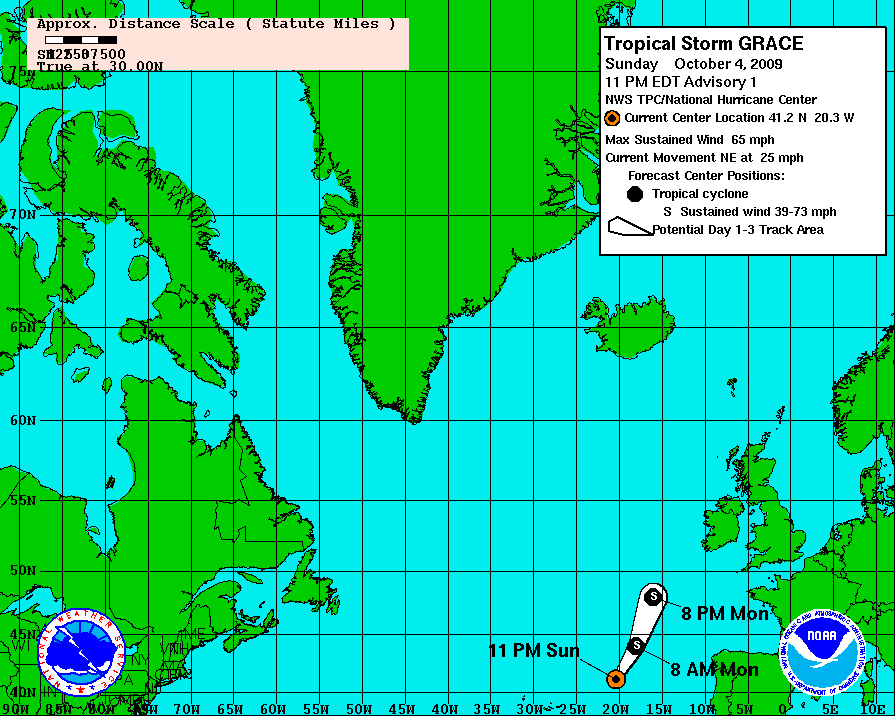
quote:LOOKS LIKE A BUSY WEEK COMING UP
All of a sudden, the Atlantic has come to life. We now have a very rare TS in the northeast Atlantic. The NHC began issuing advisories on TS Grace earlier tonight. The storm is located way out at 41N and 20W! It is tiny and should not amount to much more than an interesting footnote on this otherwise non-event season.
Of more interest is newly designated 91L in the central Atlantic. The tropical wave continues to get better organized and is also quite large. The very latest NHC hurricane models indicate that this system could strengthen steadily over the next few days and could become a tropical storm. Water temps are very warm and conditions are looking to improve as the new week wears on.
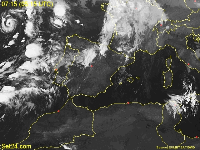
Ziet er apart uit.

jan visserquote:Een opmerkelijke ontwikkeling bij de Azoren. De Portugese eilandenarchipel heeft al enkele dagen te maken met een stroperig lagedrukgebied. Op grond van onder meer de bewolkingsstructuur en ‘tegendraadse’ bewegingen van de wolkenmassa, heeft het National Hurricane Center nabij Miami, Florida besloten het systeem uit te roepen tot de zevende tropische storm van het seizoen. Het gaat hier om GRACE die de komende 24 uur naar het zeegebied ter hoogte van Zuidwest-Ierland koerst en zich daarbij weer transformeert in een ‘gewone’ depressie.
quote:Aanhoudend wisselvallig op de lange termijn? Bel de weerlijn van Klaas de weerbaas op 0900-1234504.
Inorbit: zeg dat dan typluie triangeljosti
Beauregard: Een beetje FOK!ker laat het brood door z'n moeder smeren.
Ecosia
ek's 'n flash drive, jy's 'n floppy
Beauregard: Een beetje FOK!ker laat het brood door z'n moeder smeren.
Ecosia
ek's 'n flash drive, jy's 'n floppy


Die's uiteraard uitgedoofd als ie maar iets in de buurt komt.
misschien een staartje ?
misschien een staartje ?
| Wordfeud: marcel-o |plug.dj/uptempo |<-- draai zelf je platen
Ik denk niet dat we daar veel van mee gaan krijgen, staartje zou uiteraard kunnen maar dan van een lage drukgebied, Lagedrukgebied is immers vele malen sterker dan zo'n mini stormpje dus deze zal gewoon mee komen met de stroming. Veel wind zal het echter niet gaan opleveren hoor want zodra deze ook maar in de buurt van de noordzee komt is het snel gedaan, en Engeland houd ook al genoeg wind tegen, waarom denk je dat de meeste zware stormen uit NW hoek komt? Juist omdat er geen land is die de wind kan tegenhouden, ook het hoge water is dan vele malen hoger
<a href="https://www.youtube.com/channel/UCPueUwKfPaGH7v48LZlltkg" rel="nofollow" target="_blank">WSDokkum Youtube</a>

Die Parma blijft ook maar hangen boven noord-Filipijnen zeg... Die dingen maken wel vaker zo'n lusje, maar deze heeft wel een heel gek lusje gemaakt...

http://www.opnaardehorizon.blogspot.com, mijn reisblog over 6 maanden Zuidoost-Azië

Zullen morgen wel wat restanten over nederland heen krijgen.
"Er valt flink wat regen, soms met een buiig karakter en mogelijk onweer."
"Er valt flink wat regen, soms met een buiig karakter en mogelijk onweer."
Tyfoon stormt op Tokio af

quote:De ene storm is nog niet verdwenen of een ander monster staat al weer op in de zuidoosten van Azië. Tyfoon Melor is een storm van categorie 4 die donderdag de Japanse hoofdstad Tokio zou kunnen treffen. Melor kan windsnelheden tussen 211 en 250 kilometer per uur ontwikkelen.
Parma
De inwoners van de Filipijnen worden de laatste weken niet gespaard. Parma is gisteren gedegradeerd tot tropische storm. De storm ligt al twee dagen voor de Filipijnse kusten te loeren, maar zal waarschijnlijk niet aan land gaan. Een week geleden dumpte een andere storm in één dag nog de maandelijkse hoeveelheid regen op het land. In Manila is de schoonmaak na de overstromingen nog steeds aan de gang. Ketsana maakte zeker 300 dodelijke slachtoffers.
Japan
De komende dagen is Japan aan de beurt, want het ziet er naar uit dat Melor koers zet naar de Japanse eilanden. Vanavond zal het zuidelijke eiland Minami Daito al getroffen worden. Er worden hevige winden tot 180 kilometer per uur voorspeld, het zeeniveau kan met negen meter stijgen en de inwoners moeten rekening houden met intense regenval. Ook Tokio zal met de tyfoon te maken krijgen.
Duizenden doden
De route van Melor roept herinneringen op aan die van een verwoestende tyfoon die in 1959 duizenden levens eiste in Japan. Zo'n schade zal Melor waarschijnlijk niet aanrichten, omdat de huizen in Japan intussen steviger zijn en de kusten ook over een stormbarrière beschikken. Toch is het niet onwaarschijnlijk dat deze tyfoon ook weer voor menselijk leed zal zorgen. In augustus kwamen nog 25 Japanners om het leven bij de voorganger van Melor.

Gisteren zeiden ze dan Henry vandaag al zou verdwijnen, nu zegge ze dat pas morge of overmorgen is...quote:Op woensdag 7 oktober 2009 11:17 schreef Frutsel het volgende:
[ afbeelding ]
Henri dooft ook uit voor het land bereikt
mischien dat die nog wel veel langer leeft..
hoe gaat het eigelijkl met "onze" orkaan?
Inorbit: zeg dat dan typluie triangeljosti
Beauregard: Een beetje FOK!ker laat het brood door z'n moeder smeren.
Ecosia
ek's 'n flash drive, jy's 'n floppy
Beauregard: Een beetje FOK!ker laat het brood door z'n moeder smeren.
Ecosia
ek's 'n flash drive, jy's 'n floppy
wtf is parma ana het doen? Ik moet daar nog op vakantie gek!
Inorbit: zeg dat dan typluie triangeljosti
Beauregard: Een beetje FOK!ker laat het brood door z'n moeder smeren.
Ecosia
ek's 'n flash drive, jy's 'n floppy
Beauregard: Een beetje FOK!ker laat het brood door z'n moeder smeren.
Ecosia
ek's 'n flash drive, jy's 'n floppy
Parma gaat nu naar Vietnam enzoquote:
wtf is parma ana het doen? Ik moet daar nog op vakantie gek!
kut, nu is het eerste wat ik moet doen een vlucht gaan boeken naar palawan oid... noord filipijnen klinkt nu niet echt aantrekkelijkquote:Op woensdag 7 oktober 2009 13:23 schreef Frutsel het volgende:
[..]
Parma gaat nu naar Vietnam enzo
Inorbit: zeg dat dan typluie triangeljosti
Beauregard: Een beetje FOK!ker laat het brood door z'n moeder smeren.
Ecosia
ek's 'n flash drive, jy's 'n floppy
Beauregard: Een beetje FOK!ker laat het brood door z'n moeder smeren.
Ecosia
ek's 'n flash drive, jy's 'n floppy
quote:Krachtige tyfoon treft centrum van Japan
Een krachtige tyfoon heeft het centrum van Japan getroffen, melden autoriteiten en media. Huizen zijn beschadigd, het verkeer is lamgelegd en er vielen minstens 18 gewonden.
Hevige windstoten
De tyfoon bereikte het grote eiland Honshu donderdagmorgen om 5 uur lokale tijd. Zware windstoten van 200 kilometer per uur en hevige regenval vergezelden de tyfoon. Op de Japanse televisie verschenen beelden van rondvliegende dakpannen en afgekraakte bomen. "De wegen zijn overstroomd door de regenval", verklaarde Naoki Matsui van de prefectuur Aichi.
9.000 bewoners geëvacueerd
De openbare televisie kondigde al aan dat minstens 18 mensen gewond raakten en dat er meer dan 9.000 bewoners van de archipel geëvacueerd worden naar schuilplaatsen.
300 vluchten geschrapt
De Japanse vliegmaatschappijen zullen meer dan 300 binnenlandse vluchten schrappen, terwijl ook het spoorverkeer stilgelegd wordt. In 1959 had een gelijkaardige tyfoon in Japan 5000 doden tot gevolg.


WILL MJO PULSE RESULT IN BURST OF NAMED STORMS FOR THE ATLANTIC? WE ARE GOING TO FIND OUTSOON ENOUGH
I wanted to write about a phenomenon that few people ever hear about except for those who really follow tropical weather. It is called the MJO for Madden-Julian Ocscillation. What is it? Here is a direct quote from the MJO resource page from the Climate Prediction Center's site
The MJO is an intraseasonal fluctuation or �wave� occurring in the global tropics. The MJO is responsible for the majority of weather variability in these regions and results in variations in several important atmospheric and oceanic parameters which include both lower- and upper-level wind speed and direction, cloudiness, rainfall, sea surface temperature (SST), and ocean surface evaporation. The MJO is a naturally occurring component of our coupled ocean-atmosphere system and the typical length of the MJO cycle or wave is approximately 30-60 days (Madden and Julian, 1971, 1972; Madden and Julian, 1994; Zhang, 2005).
Another way to look at the MJO is that when it is favorable for convection we essentially have a period of favorable upward motion in the atmosphere. This then leads to increased convection which in turns favors the genesis of storms- and specifically, tropical cyclones. Computer models predict the progress of the MJO and can be helpful in understanding when a certain region of the tropics is likely to have conditions conducive for development. It is not a cure-all 100% piece of the puzzle but the MJO can be a key indicator that we are entering a period where tropical storm formation is more likely than not. Make sense so far? So, looking at the graphic I have posted, the browns and rust colors indicate sinking air and conditions generally unfavorable for tropical convection. The green areas, especially the darker greens, indicate large scale upward motion in the atmosphere and hence the possibility for ripe conditions aloft. The map shows the next 15 days as predicted by the GFS model. We can see that as we progress through the next two weeks, a strong pulse of upward motion moves in to the southeast Pacific and then in to the western Atlantic Basin- including the Gulf of Mexico. Here is another quote from the CPC site regarding the MJO's influence on tropical cyclone formation:
The MJO is known to modulate tropical cyclone activity in the Indian Ocean, Pacific Ocean, Gulf of Mexico, and Atlantic Ocean (Maloney and Hartmann, 2000a; Maloney and Hartmann, 2000b; Higgins and Shi, 2001). For example, although tropical cyclones occur throughout the Northern Hemisphere warm season (typically May-November) in both the Pacific and the Atlantic basins, in any given year there are periods of enhanced / suppressed activity within the season. The MJO modulates this activity (particularly for the strongest storms) by providing a large-scale environment that is favorable (unfavorable) for development. For example, westerly wind anomalies at the surface in and just behind the area of enhanced convection of the MJO may generate cyclonic (anticyclonic) rotation north (south) of the equator respectively (Figure 2). At the same time, in the upper levels, anticyclonic (cyclonic) rotation develops along and just behind the area of convection (Figure 2) resulting in a means to reduce vertical wind shear and increase upper-level divergence � both of which are favorable for tropical cyclone development and intensification. The strongest tropical cyclones tend to develop when the MJO favors enhanced precipitation. As the MJO progresses eastward, the favored region for tropical cyclone activity also shifts eastward from the Indian Ocean to the Pacific Ocean and eventually to the Atlantic Ocean (Figure 10). While this relationship appears robust, we caution that the MJO is one of many factors that contribute to the development of tropical cyclones. For example, it is well known that SSTs must be sufficiently warm and vertical wind shear must be sufficiently weak for tropical disturbances to form and persist.
So what does this all mean for the next two weeks or even longer?
It might turn out to mean absolutely nothing- and we don't see any additional development in the tropics. However, it more than likely indicates that we will see an increase in activity in the southeast Pacific first, followed by one or two tropical storms forming in the Atlantic- probably west of 60W longitude. The models are not indicating anything specific as of yet but with this pulse moving through, it may only be a matter of time until we see something significant develop. There is no way to know when where and how strong but this large piece of the tropical cyclone puzzle is interesting to monitor and helps to know when to really start looking. Climatologically speaking, the next two weeks would be a favored time of year anyway as we see a mini-spike in activity during this period over the last 100 years. The bottom line is that we continue to see a nice quiet tropics for the most part but IF something is going to come along and spoil everything, it is my opinion that it will happen within the next two weeks. This makes logical sense but is in no way a prediction on my part. The odds are that we will be just fine but again, I emphasize that IF there is going to be a hurricane problem for ANY land area, I think it will come between now and the end of the month. This sounds a little obvious considering that once we reach November the chances really diminish but this pulse is fairly strong in the models so we'll have to see what happens- if anything at all.!
==============
Interessant
Meer over de MJO --> Wiki: MJO
quote:[url=
Nieuwste]http://www.hln.be/hln/nl/2652/Extreem-Weer/article/detail/1014870/2009/10/13/Nieuwste-tropische-storm-heet-Patricia-en-trekt-naar-Mexico.dhtml]Nieuwste tropische storm heet Patricia en trekt naar Mexico[/url]
Het stormseizoen bereikt de laatste weken zijn hoogtepunt. Na de tyfoons die vorige week de Filipijnen en Japan troffen (foto boven), ontwaakt in de Stille Oceaan opnieuw een zware storm. Deze keer lijkt Mexico het slachtoffer te worden. Patricia haalt windsnelheden tot 95 kilometer per uur en is daarmee voorlopig een tropische storm, en dus geen orkaan.
Het schiereiland dat langs het westen van Mexico in de oceaan uitsteekt, maakt zich op voor de komst van Patricia. De storm zou in de loop van de dag toeslaan en kan overstromingen en schade veroorzaken. In Los Cabos, een populair toeristisch plekje, werden de scholen en havenfaciliteiten uit voorzorg gesloten. Twee laag gelegen buurten werden zelfs geëvacueerd.
Patricia zal waarschijnlijk geen orkaan worden. Daarvoor zijn windsnelheden van minstens 119 kilometer per uur nodig. Vorige maand kreeg het schiereiland het bezoek van Jimena. Die storm was wel een orkaan en eiste ook één dode in Mexico.
In de noord west pacific is ook weer een storm ontstaan. Die weer in de richting van de Fillipijnen / Taiwan trekt.
[ Bericht 0% gewijzigd door #ANONIEM op 14-10-2009 11:15:34 ]

[ Bericht 0% gewijzigd door #ANONIEM op 14-10-2009 11:15:34 ]
Storm Parma noopt tot evacuaties in Vietnam
(Novum/AP) - In het noordelijk kustgebied van Vietnam zijn zo'n dertigduizend mensen geëvacueerd met het oog op de naderende tropische storm Parma. Parma wordt in de loop van woensdagavond in Vietnam verwacht.
Eerder deze maand sloeg Parma toe in de Filipijnen en China, waar hij respectievelijk 375 en drie doden veroorzaakte. De Filipijnen zijn sinds 26 september eerst door de tyfoon Ketsana en daarna door Parma geteisterd. Het noodweer heeft aan in totaal meer dan zevenhonderd Filipijnen het leven gekost.
trouw
En hoeveel wind zit er nog in dan?quote:
Storm Parma noopt tot evacuaties in Vietnam
(Novum/AP) - In het noordelijk kustgebied van Vietnam zijn zo'n dertigduizend mensen geëvacueerd met het oog op de naderende tropische storm Parma. Parma wordt in de loop van woensdagavond in Vietnam verwacht.
Eerder deze maand sloeg Parma toe in de Filipijnen en China, waar hij respectievelijk 375 en drie doden veroorzaakte. De Filipijnen zijn sinds 26 september eerst door de tyfoon Ketsana en daarna door Parma geteisterd. Het noodweer heeft aan in totaal meer dan zevenhonderd Filipijnen het leven gekost.
trouw
Ik heb verschillende meteogrammen bekenen in die buurt maar dan kracht 4/5 zit er niet in, zelfs hier NL staan nog meer windvaantjes.
Misschien dat ik een beetje verkeerd kijk....iemand misschien een plaats waar die ongeveer over komt?
<a href="https://www.youtube.com/channel/UCPueUwKfPaGH7v48LZlltkg" rel="nofollow" target="_blank">WSDokkum Youtube</a>

Mah kan sneller hoor
Mega storm? Katrina en Wilma niet te vergeten
Mega storm? Katrina en Wilma niet te vergeten
<a href="https://www.youtube.com/channel/UCPueUwKfPaGH7v48LZlltkg" rel="nofollow" target="_blank">WSDokkum Youtube</a>
Zal Lupit net zo'n rare storm worden als Parma? Vooralsnog ziet het er (wéér) niet goed uit voor de Filipijnen...

http://www.opnaardehorizon.blogspot.com, mijn reisblog over 6 maanden Zuidoost-Azië

Niet goed? Ach als er nou eens live cam / gegevens op i-net stonden 
Maar indd ze hebben nu wel weer genoeg gehad.
Maar indd ze hebben nu wel weer genoeg gehad.
<a href="https://www.youtube.com/channel/UCPueUwKfPaGH7v48LZlltkg" rel="nofollow" target="_blank">WSDokkum Youtube</a>
En waar gaat die heen?
<a href="https://www.youtube.com/channel/UCPueUwKfPaGH7v48LZlltkg" rel="nofollow" target="_blank">WSDokkum Youtube</a>
Het noorden van de Fillipijnen krijgt wederom een zware Typhoon over zich heen. Over 3/4 dagen komt Lupit op bezoek. De koers kan nog wel veranderen, maar een landfall zal zeker ergens gaan plaatsvinden.


En valt allemaal wel weer mee
<a href="https://www.youtube.com/channel/UCPueUwKfPaGH7v48LZlltkg" rel="nofollow" target="_blank">WSDokkum Youtube</a>
Dat oorkaantje bij Mexico
Landfall van cat 2, ach we zijn tegenwoordig wel meer gewend
Landfall van cat 2, ach we zijn tegenwoordig wel meer gewend
<a href="https://www.youtube.com/channel/UCPueUwKfPaGH7v48LZlltkg" rel="nofollow" target="_blank">WSDokkum Youtube</a>
quote:"Orkaan Rick blijft extreem gevaarlijk"
De orkaan Rick, die de kusten van Mexico aan de Stille Oceaan onveilig maakte, is afgezwakt en heeft nu een kracht van vier op de schaal van Saffir-Simpson, die vijf categorieën telt, meldt het Amerikaanse National Hurricane Centre (NHC) in Miami. Het NHC waarschuwt echter wel dat Rick "extreem gevaarlijk" blijft. De orkaan gaat gepaard met windvlagen tot 230 kilometer per uur.
Vanochtend bevond Rick zich op ongeveer 660 kilometer ten zuiden van het luxueuze badplaats Los Cabos en zette hij zijn tocht voort naar het noordwesten langs de zuidkust van Mexico.
Morgen zal de orkaan volgens het NHC naar het noorden trekken en in de volgende 24 tot 48 uur moet Rick aan intensiteit inboeten. Rick is de zevende orkaan van het orkaanseizoen 2009 in het noordoosten van de Stille Oceaan. Zaterdag bereikte hij de hoogste categorie van vijf op de schaal van Saffir-Simpson.(Bron: HLN)

quote:Typhoon Lupit a potential major disaster for the Philippines
Category 4 Super Typhoon Lupit has begun its turn to the west over the Philippine Sea, and is headed towards a landfall early Thursday morning on the northern portion of Luzon Island in the Philippines. Thanks to the departure of a trough of low pressure that was pulling the super typhoon to the northeast and creating a region of weak steering currents, a strong ridge of high pressure is now building in over Lupit and will force it slightly south of due west. The models are all in excellent agreement on the forecast track taking the super typhoon over northern Luzon as a major Category 3 or 4 typhoon, and Lupit--the Filipino word for cruel--is very likely to live up to its name. The northern Philippines are still reeling from the rains and mudslides unleashed by Super Typhoon Parma last week, which crossed over the northern Philippines three times, dumping over twenty inches of rain in many locations. Parma killed 438 people, and 51 are still missing. A week prior to Parma, Typhoon Ketsana brought the heaviest rains in 42 years to the capital of Manila, killing 420 people, with 37 still missing.
Die is al volop bezig bij 1 van die eilandjes.quote:
Hij gaat de Mexicaantjes opjagen
[ afbeelding ]

En dan verderop in isla san juanito zelfs een windkracht 10bft, deze windvaan heb ik nog niet eerder in meteogrammen gezien

[ Bericht 16% gewijzigd door SpeedyGJ op 19-10-2009 19:41:12 ]
<a href="https://www.youtube.com/channel/UCPueUwKfPaGH7v48LZlltkg" rel="nofollow" target="_blank">WSDokkum Youtube</a>
Inmiddels is de orkaan aangekomen bij Isla socorro

<a href="https://www.youtube.com/channel/UCPueUwKfPaGH7v48LZlltkg" rel="nofollow" target="_blank">WSDokkum Youtube</a>
quote:Eerste dode door orkaan Rick
De orkaan Rick heeft een dodelijk slachtoffer gemaakt in de Mexicaanse badplaats Los Cabos. Dat meldt de civiele bescherming. De 38-jarige man was ondanks de waarschuwingen van de Mexicaanse overheid gaan zwemmen. Hij werd meegesleurd door een enorme golf. De orkaan Rick zal naar verwachting morgenvroeg in Los Cabos, aan de westkust van Mexico, aan land komen.
quote:WE NOW HAVE 94L IN THE WESTERN CARIBBEAN
The NHC has designated the area of disturbed weather in the western Caribbean as 94L. For those who may not know what that means, it is a numbering system used to allocate more resources for a suspect area of weather in the hurricane breeding grounds of the world. The various agencies use the numbers 90-99 and a letter, in this case "L For Atlantic, and then start over as needed. We will go through a couple dozen of these "invests" each season at least. So- what is the future for 94L? Looks like it will be slow going with development with a northward drift. The first intensity model, the SHIPS, shows it reaching moderate tropical storm strength in about five days. It is very early in the evolution of this system but I think it is likely that we will see additional development from it over the next several days. Interests in the western and northern Caribbean should keep a close eye on the situation. At the very least, unsettled weather will prevail.

quote:MANILA, 20 October 2009 (IRIN) - Rescue and relief officials are rushing supplies and food to the north of the Philippines, while thousands of people living in areas prone to landslides and flooding were ordered on 20 October to evacuate to safer areas, as Typhoon Lupit was due to make landfall.
Packing maximum sustained winds of 195km near the centre with gusts of 230km/hour, Lupit's eye was estimated at 820km east-northeast of the province of Cagayan, in the northern island of Luzon.
While it is expected to make landfall only on 22 October, its wide outer rain bands could bring heavy rains and strong winds to northern provinces a day earlier, the state weather bureau said.
The National Disaster Coordinating Council (NDCC) in Manila said nearly 100 tonnes of food and other relief items had been trucked or airlifted to northern provinces where Lupit was expected to hit.
Lupit comes as the country continues to reel from the devastation wrought by twin typhoons that left 858 people dead and entire areas under flood waters for the past three weeks.


Rare trekrichting 
Sommige orkanen zijn erg apart, laatst 1 gezien die 2X landfall maakte
Eerste over Amerika, vervolgens trekt niet naar het oosten en kwam boven zee weer tot orkaan om vervolgens nog eens een landfall te maken
Sommige orkanen zijn erg apart, laatst 1 gezien die 2X landfall maakte
Eerste over Amerika, vervolgens trekt niet naar het oosten en kwam boven zee weer tot orkaan om vervolgens nog eens een landfall te maken
<a href="https://www.youtube.com/channel/UCPueUwKfPaGH7v48LZlltkg" rel="nofollow" target="_blank">WSDokkum Youtube</a>
quote:Op zaterdag 24 oktober 2009 17:54 schreef SpeedyGJ het volgende:
Rare trekrichting
Sommige orkanen zijn erg apart, laatst 1 gezien die 2X landfall maakte
Eerste over Amerika, vervolgens trekt niet naar het oosten en kwam boven zee weer tot orkaan om vervolgens nog eens een landfall te maken

Nee dat was em niet.
Hij ging ongeveer op deze manier, ik zal em nog eens opzoeken

Hij ging ongeveer op deze manier, ik zal em nog eens opzoeken
<a href="https://www.youtube.com/channel/UCPueUwKfPaGH7v48LZlltkg" rel="nofollow" target="_blank">WSDokkum Youtube</a>
Hier paar orkanen die toch wel een aparte trekrichting hadden, zo zie je maar dat orkanen best lang kunnen overleven
Allison
Ivan- Deze bedoelde ik
Jeanne
Allison

Ivan- Deze bedoelde ik

Jeanne

<a href="https://www.youtube.com/channel/UCPueUwKfPaGH7v48LZlltkg" rel="nofollow" target="_blank">WSDokkum Youtube</a>
Typhoon Lupit
Typhoon Lupit continued heading toward the Philippines on October 22–23, 2009. QuikSCAT collected these wind measurements at 5:47 p.m. Manila time (09:47 UTC) on October 22, 2009. Wind speeds are color coded with the strongest winds, shown in pink and purple, occurring near the center of the storm. Barbs indicate wind direction.
QuikSCAT monitors wind speed with a radar that sends out pulses of microwave energy and listens for the echo after the pulse bounces off the wind-roughened ocean surface. Scientists translate radar signals into estimates of wind speed by matching the radar echoes to physical measurements collected from buoys at the same time and place.
Cyclone-strength wind speeds are rare, however, and scientists generally don’t have enough matching buoy observations to convert wind speeds above roughly 50 knots. Intense rain rippling the ocean’s surface can also interfere with the radar signal. Because of these limitations, QuikSCAT images don’t show absolute, maximum wind speeds. Instead, they give forecasters a valuable picture of the wind structure within the storm, for example, revealing whether a storm has a strong or a weak eye and how large an area is experiencing tropical-storm-strength winds.
As of 5:00 a.m. October 23 Manila time (21:00 October 22 UTC), Typhoon Lupit was roughly 285 nautical miles (approximately 530 kilometers) north-northeast of Manila, continuing its westward path in the direction of the island nation, according to the U.S. Navy’s Joint Typhoon Warning Center. At that time, Lupit had maximum sustained winds of 65 knots (120 kilometers) with gusts up to 80 knots (150 kilometers per hour).
Ze kunnen het wel lang volhouden ja. Er is een storm geweest die 28 dagen een tropische storm of orkaan status heeft gehad.quote:Op zondag 25 oktober 2009 10:54 schreef SpeedyGJ het volgende:
Hier paar orkanen die toch wel een aparte trekrichting hadden, zo zie je maar dat orkanen best lang kunnen overleven
Allison
[ afbeelding ]
Ivan- Deze bedoelde ik
[ afbeelding ]
Jeanne
[ afbeelding ]
quote:De Sint Cyriacus-orkaan (Spaans: Huracán de San Ciriaco), was een orkaan van de vierde categorie in het Atlantisch orkaanseizoen 1899. De Sint Cyriacus-orkaan had de langste levensduur, die bij een tropische cycloon is waargenomen. Deze orkaan was van het Kaapverdische type en behield 28 dagen, van 3 augustus tot 22 augustus en van 26 augustus tot 4 september, de status van tropische storm of orkaan. De orkaan is vernoemd naar Sint Cyriacus, een der Noodhelpers, omdat de orkaan op de naamdag van de heilige, 8 augustus landde op Puerto Rico. Door de lange levensduur vertoonde de Sint Cyriacus-orkaan de hoogste activiteit, die ooit is waargenomen bij een tropische cycloon.
[ Bericht 26% gewijzigd door #ANONIEM op 25-10-2009 21:08:33 ]
quote:Katrina was only just the beginning...
De zuidelijke staten van de VS zijn het meest kwetsbaar voor de gevolgen van de klimaatverandering. In dertien staten kan de klimaatverandering rampzalige gevolgen hebben als de arme bevolking er te maken krijgt met droogte, overstromingen, orkanen en een hoger zeeniveau.
Van Arkansas tot Virginia liggen een aantal 'hotspots' die extreem gevoelig zijn voor de impact van de klimaatverandering. "Sociale factoren als inkomen en ras bepalen niet wie het hardst getroffen wordt door de klimaatverandering, maar ze bepalen wel of een bevolking in staat is zich voor te bereiden en te antwoorden op natuurrampen", zegt de Amerikaanse Oxfam-voorzitter Raymond Offenheiser. "Terwijl de klimaatverandering sterker wordt en hittegolven en stormen in intensiteit toenemen, zullen de armste landen ter wereld onder een ongeziene druk komen te staan."
Klimaatplan
Uit de studie van Oxfam blijkt dus dat de Verenigde Staten zelf ook al heel kwetsbaar zijn voor global warming. Toch lijkt het opstellen van een klimaatplan net daar weer voor de meeste problemen te zorgen. President Barack Obama zal de grootste moeite hebben om zijn klimaatwet voor de VN-klimaatconferentie in Kopenhagen (7-18 december) door de Senaat te krijgen. "De regering moet nu antwoorden op global warming en investeren in de bescherming van de armste gemeenschappen in de VS", aldus Oxfam.
Katrina
Eén van de belangrijkste gevarenzones is Iberia Parish in Louisiana. Daar ligt 76,8 procent in overstromingsgebied, 78,9 procent in een droge zone, 56 procent in een kwetsbaar gebied als het zeeniveau stijgt en, alsof dat nog niet genoeg is, ligt de hele regio ook nog eens in een orkaanzone. De inwoners zijn extreem kwetsbaar omdat er veel Latino's met jonge kinderen wonen. De ongelijkheid der rassen is er nog altijd een groot probleem.
Lousiana weet wat het is als het noodlot toeslaat. In 2005 toverde orkaan Katrina Louisiana in enkele uren om tot een puinhoop. De armste gezinnen waren de grootste slachtoffers.
Florida
Maar ook Florida - in de ogen van vele mensen nochtans een rijke staat - behoort tot de risicogebieden. Miami-Dade County is kwestbaar omdat er veel gezinnen wonen waar vrouwen met een laag inkomen het huishouden moeten onderhouden. Bovendien wonen er veel arme migranten. Andere extreem kwetsbare gebieden zijn het zuiden van Texas, het zuiden van Lousiana, het westen van Florida, het westen van Alabama en de kusten van South Carolina.
Dat kan nog wat wordenquote:
[ Bericht 99% gewijzigd door SpeedyGJ op 26-10-2009 12:16:31 ]
<a href="https://www.youtube.com/channel/UCPueUwKfPaGH7v48LZlltkg" rel="nofollow" target="_blank">WSDokkum Youtube</a>

Even een tip:
Misschien handig om die track plaatjes te uploaden?
Want als je nu de text bekijkt bij het plaatje dan klopt de verhouding totaal niet meer
Misschien handig om die track plaatjes te uploaden?
Want als je nu de text bekijkt bij het plaatje dan klopt de verhouding totaal niet meer
<a href="https://www.youtube.com/channel/UCPueUwKfPaGH7v48LZlltkg" rel="nofollow" target="_blank">WSDokkum Youtube</a>

Klopt wel... maar ik denk dat veel users niet weten hoe dat moet of niet de moeite nemen.
Effe snel wat laten zien, zelf doe ik dat ook. Maar je hebt wel een punt
Effe snel wat laten zien, zelf doe ik dat ook. Maar je hebt wel een punt
Ik heb eens een uitleg gemaakt hoe je dat het beste kan doen, ik ben bereid om dit nog eens te doen voor de users
<a href="https://www.youtube.com/channel/UCPueUwKfPaGH7v48LZlltkg" rel="nofollow" target="_blank">WSDokkum Youtube</a>

Indd, maar werk liever met photobucket, heb ik alle foto's / afbeeldingen bij de hand
Maar goed laten we niet te ver afdwalen
Maar goed laten we niet te ver afdwalen
<a href="https://www.youtube.com/channel/UCPueUwKfPaGH7v48LZlltkg" rel="nofollow" target="_blank">WSDokkum Youtube</a>

Zowel meer als minder orkanen door El Nino?
In de Atlantische Oceaan zijn dit orkaanseizoen, dat loopt van augustus tot en met oktober, eigenlijk maar weinig orkanen geweest. Dit in tegenstelling tot een aantal andere gebieden, die geregeld het nieuws haalden. Krachtige tropische stormen en orkaangeweld wisten daar namelijk veel schade aan te richten. In dit verhaal zullen we uitleggen waarom de orkanen zich nu juist niet in het Atlantisch gebied voordoen.
Als we de balans opmaken voor de Atlantische Oceaan dan komen we niet verder dan een lijstje met 10 noemenswaardige gebeurtenissen. Dit jaar deden zich twee orkanen voor (Bill en Fred), 6 tropische stormen (Ana, Claudette, Danny, Erika, Grace en Henri) en twee tropische depressies (nummer één en acht).
El Nino
Veel vaker deden dergelijke monsterstormen zich voor aan de westkust van Amerika. En ook een aantal ontwikkelingslanden kreeg veel stormgeweld over zich heen. Momenteel koerst bijvoorbeeld al de vierde tyfoon, Mirinae genaamd, op de Filippijnen af. Het fenomeen El Nino blijkt aan de basis te staan voor de huidige stand van zaken wat orkanen betreft.
El Nino is vooral bekend om zijn gevolgen in Peru en Indonesië. Door veranderende stromingen krijgt men te maken met andere zeewatertemperaturen. De vissers van Peru merken dat het koude en voedselrijke water, dat normaal gesproken vanuit de Zuidpool langs de kust stroomt, plaatst maakt voor warmer water. Hierdoor vangen de vissers minder vis en ook veroorzaakt het warmere water meer buien, met overstromingen tot gevolg.
In de omgeving van Indonesië gebeurt het tegenovergestelde. In plaatst van warm zeewater stroomt kouder zeewater de regio binnen. Normaal staat deze regio bekend als een nat gebied, maar door het koude water wordt de neerslagactiviteit getemperd. Het gevolg is extreme droogte, waardoor achtereenvolgens bosbranden en smog ontstaan.
Wereldwijde gevolgen
Al enige tijd is bekend dat de gevolgen van El Nino veel verder gaan dan de omgeving van Zuid-Amerika en Indonesië. Niet alleen daar veranderen de stromingspatronen (in zowel de lucht als de zee), maar wereldwijd. El Nino heeft dus ook gevolgen voor de Atlantische Oceaan. Gevolgen die de vorming van tropische stormen en orkanen tegen gaan.
In de Atlantische Oceaan zijn tijdens een El Nino de veranderingen in zeewatertemperatuur niet of nauwelijks aanwezig. De reden voor minder orkanen en tropische stormen moeten we dus niet zoeken bij het zeewater, maar bij de wind. Tijdens een El Nino blijkt er namelijk meer verticale windschering te zijn in de ontstaansgebieden.
Het ontstaan van orkanen
Orkanen in de Atlantische Oceaan vinden hun oorsprong voor de westkust van Afrika. Onweersbuien weten zich hier, boven zeewater van tenminste 27 graden, verder te organiseren. Deze onweerscomplexen worden met de oostelijke wind meegenomen richting Amerika. Boven het warme zeewater worden de systemen steeds actiever en groeien ze mogelijk uit tot achtereenvolgens tropische depressies, tropische stormen en orkanen.
Een belangrijke voorwaarde hiervoor is dat de wind met de hoogte niet teveel verandert wat windrichting en windsterkte betreft. Tijdens een El Nino is deze zogenaamde verticale windschering echter een stuk sterker dan normaal. De toppen van deze stormsystemen worden daardoor meer uiteengewaaid, waardoor ze zich niet kunnen organiseren. Tijdens een La Nina, de tegenhanger van El Nino, is van verticale windschering niet of nauwelijks sprake. Onweerscomplexen kunnen zich dan wel organiseren, met een actief orkaanseizoen tot gevolg.
Afnemende El Nino
De huidige El Nino lijkt overigens momenteel alweer op zijn retour te zijn. Of we daarmee opnieuw op een La Nina afstevenen is nog niet te zeggen. Wel lijken hiermee de orkaankansen in de Atlantische Oceaan voor volgend jaar weer groter te worden.
Filipijnse regering raadt kerkhofbezoek af door tyfoon
De regering van de Filipijnen heeft haar bevolking opgeroepen af te zien van het traditionele kerkhofbezoek op Allerheiligen. Ze doet dit uit angst voor een naderende tyfoon.
Vermoedelijk op zaterdag zal tyfoon "Mirinae" de eilandengroep in de Stille Oceaan treffen. En net op die dag zullen vele bewoners naar hun geboorteplaatsen terugkeren door de feestdag op zondag. "Laat ons vermijden de kerkhoven te bezoeken. Wie echt wil gaan kan dat beter voor zondag doen", zei minister van Defensie Gilberto Teodoro vandaag.
Allerheiligen op 1 november is op de overwegend katholieke Filipijnen traditiegetrouw de dag dat de mensen de graven van hun overleden nabestaanden bezoeken. Tienduizenden mensen overnachten dan zelfs op de kerkhoven. Het groot aantal mensen op het platteland kan tot problemen leiden als de tyfoon de Filipijnen treft. Dat heeft minister Teodoro gezegd. "Ze kunnen daar ingesloten geraken, het verkeer belemmeren en de mogelijke hulpmaatregelen vertragen, die onder omstandigheden nodig zijn".
Doden bij eerdere tyfoon
De Filipijnen werden pas in september nog door een zware storm getroffen, waarna een nieuwe tyfoon overstromingen en grondverschuivingen veroorzaakte. Bijna 1.000 mensen kwamen om en er werd voor meer dan 530 miljoen euro materiële schade aangericht.
De nieuwe tyfoon "Mirinae" trekt momenteel tegen een snelheid van 135 km/u in noordwestelijke richting over de Stille Oceaan. Volgens de voorspellingen kan de taifoen de hoofdstad Manilla met 1,7 miljoen inwoners treffen. (dpa/ka)
hln
Vlucht was gecanceld naar Manilla... misschien vanmiddag meer geluk
Typhoons zijn niet leuk als je er dicht in de buurt bent ;-)
Inorbit: zeg dat dan typluie triangeljosti
Beauregard: Een beetje FOK!ker laat het brood door z'n moeder smeren.
Ecosia
ek's 'n flash drive, jy's 'n floppy
Beauregard: Een beetje FOK!ker laat het brood door z'n moeder smeren.
Ecosia
ek's 'n flash drive, jy's 'n floppy
Doden door tyfoon Filipijnen
MANILLA - Voor de derde keer in vijf weken is het grootste eiland van de Filipijnen getroffen door een tyfoon.
De storm heeft zaterdag overstromingen veroorzaakt in de gebieden op Luzon die nog niet hersteld waren van de eerdere natuurrampen.
Door tyfoon Mirinae zijn zeker vier mensen om het leven gekomen, maakte het leger bekend. Ook worden nog mensen vermist, onder meer een 1-jarig kind.
Reddingwerkers
De provincies Laguna en Batangas ten zuiden van Manilla lijken het zwaarst getroffen. Reddingswerkers proberen mensen van de daken van hun huizen te redden.
Ook de politie en het leger zijn ingezet. De burgemeester van de stad Santa Cruz heeft gevraagd om meer helikopters en rubberboten om alle slachtoffers te kunnen bereiken.
Stormen
Door de twee eerdere stormen kwamen zeker 1100 mensen om het leven. Ketsana, die eind september over Luzon raasde, zette grote delen van Manilla onder water.
De stad ondervindt nog steeds veel overlast van die overstromingen. De overheid evacueerde wegens Mirinae uit voorzorg 115.000 mensen.
nu.nl
De restanten van Neki zorgen nog voor overlast aan de west kust van Canada en Alaska.
Remnants of Neki Slamming British Columbia
Remnants of Neki Slamming British Columbia
quote:As a big storm plows into British Columbia and the Alaska Panhandle this weekend, most of its affects will stay north of the northwestern United States.
The storm essentially has the "guts" of Neki, which caused trouble west of Hawaii last week as a powerful hurricane.
While coastal British Columbia and the Alaska Panhandle are typically hit with eight to twelve strong storm systems during the winter months, this one will bring an extra punch in the form of extra strong winds and torrential rainfall.
Hurricane-force gusts and locally more than 6 inches of rain can fall at sea level along the coast and into the coastal mountains.
As this system moves inland today, winds will weaken. However, it will transition to a colder storm, causing snow levels to lower over much of British Columbia and the Canadian Rockies.
in manilla was niets te zien was stormschade
Inorbit: zeg dat dan typluie triangeljosti
Beauregard: Een beetje FOK!ker laat het brood door z'n moeder smeren.
Ecosia
ek's 'n flash drive, jy's 'n floppy
Beauregard: Een beetje FOK!ker laat het brood door z'n moeder smeren.
Ecosia
ek's 'n flash drive, jy's 'n floppy
WILL NOVEMBER BRING A STORM TO THE GULF? ALSO, A LOOK AT PAST EL NINOS AND THE FOLLOWING HURRICANE SEASONS
October was very quiet across the Atlantic Basin. Only two tropical storms formed- Grace and Henri. Now that we are in the last official month of the hurricane season, overall activity really drops off if we look at the climatological norm. However, I am seeing indications from some of the global models that suggest we could see a tropical system develop somewhere in the southern Gulf of Mexico over the coming week. In addition, the NHC has been watching a non-tropical area of low pressure well east of Bermuda for possible development. It seems that its chance to do something may have come and gone over the weekend as deep thunderstorms over the center have diminished. So, the only area to monitor will be the western Caribbean and southern Gulf of Mexico. This morning, we do see a loosely defined area of showers and thunderstorms to the west of the Yucatan peninsula, in the Bay of Campeche. There is also some increasing convection down in the SW Caribbean. The models suggest that this whole mess will slowly organize and could produce a tropical depression in the region towards the end of the week or next weekend. It is tough to say where this might happen as unsettled weather should prevail across the western Caribbean and southern Gulf for the time being. It will be interesting to watch. I would put my money on something developing in the Caribbean over the Gulf but we will see. What ever happens, if anything at all, will be slow going.
In El Nino related news, you may have heard recently that the current El Nino has strengthened some. We are now in a moderate event with fairly significant anomalies in the sea surface temps across a great deal of the Equatorial Pacific. I thought it would be interesting to compare this El Nino with some of the recent past- dating back to the 1982-83 event to current. I am looking for what happened during the hurricane seasons following these warm events, possibly finding clues to what might take place next season. Here is what I found:
El Nino of 1982-1983: following hurricane season in 1984 had 13 named storms. Most notable was hurricane Diana which became a category four hurricane just off the North Carolina coast before making landfall near Wilmington as a category one.
El Nino of 1986-1987: following hurricane season of 1988 had 12 named storms including powerful hurricane Gilbert which struck Jamaica and then the Yucatan before making a final landfall in Mexico, just south of Brownsville, TX. Note too that 1989 featured hurricane Hugo- the category four monster that made landfall near Charleston, SC.
El Nino of 1991-1992: following hurricane season in 1993 had eight named storms with the most notable being category three hurricane Emily which came within 20 miles or so of making landfall at Cape Hatteras, North Carolina.
El Nino of 1997-1998- strongest on record to date: the following hurricane seasons of 1998 & 1999 (the El Nino dramatically reversed in 1998) had a combined total of 26 named storms. Of note were hurricanes Bonnie and Georges in 1998 and Bret, Dennis and Floyd in 1999. Also, hurricane Irene struck south Florida in October of 1999.
El Nino of 2002, fairly weak but still an El Nino year: the following season of 2003 had sixteen named storms including category 5 hurricane Isabel which hit North Carolina as a category two hurricane. Also had hurricane Fabian which struck Bermuda and hurricane Juan which severely impacted Nova Scotia.
El Nino of 2006- also a fairly weak event: the following hurricane season of 2007 was marked by mainly low-latitude strong hurricanes which impacted Central America and quick-fuse hurricane Humberto which hit near High Island, Texas.
The bottom line is that in all but two of the last six El Nino events, the United States was significantly impacted by hurricanes the following non-El Nino season. Note that post-1995 seasons would all be within ths recent up-tick in hurricane activity for the Atlantic Basin where as the 1980s events were not during a warm Atlantic period. Does this lend any clues as to what we might expect for 2010? Possibly. We know that an El Nino event in the Pacific usually acts to thwart development in the Atlantic and is sure seems to have played that role this season. If we do not have an El Nino present next season, that would at least remove the negative conditions brought on by the warmer Pacific. However, other factors are involved such as African dust outbreaks, the strength and position of the Bermuda/Azores High and sea surface temperatures across the Atlantic Basin. Since wek now that El Nino is usually an inhibiting factor for Atlantic hurricane development, we can at least track its progress during the next seven months and see where we end up by June of 2010. If the Pacific cools to neutral but not a strong La Nina, then I would imagine we will see a much more active season next year. It is unusual for El Nino to stick around for more than a year- but nothing is impossible. I'll post updates about the current El Nino throughout the off-season and we'll address it in detail on future editions of our HurricaneTrack News/Talk program. For now, we can expect the current moderate event to stick around through the winter months at least.
===
Ben benieuwd of 2010 idd meer orkanen brengt... maar hey, meer dan 2009 is haast onvermijdelijk
zie ook --> El Niño: Terug van weggeweest?
MIRINAE is al tropische storm aangekomen bij Vietnam. Daar zal ook wel weer de nodige overlast ontstaan.
quote:SLOW BREWING SYSTEM IN THE SOUTHWEST CARIBBEAN
We will be monitoring one area over the next several days for possible tropical storm formation and that is the southwest Caribbean Sea. A weak area of low pressure is situated in the vicinity of Panama and Costa Rica. Most of the computer models slowly organize this system as it moves very little over the next five to seven days. None of the models show it getting too strong which would be good news for any land areas affected down the road. However, it will produce heavy rains for portions of Central America which is always a concerin with tropical systems. We'll keep tabs on it, have plenty of time to see what develops - if anything at all. The rest of the tropics are closed for business.
quote:Dodental Vietnam loopt op naar veertig
Het dodental van de tropische storm Mirinae in Centraal-Vietnam is gestegen tot minstens veertig. Er zijn ook elf vermisten. In verschillende steden traden rivieren buiten hun oevers. Straten staan meer dan een meter onder water. Alleen al in de Vietnamese provincie Phu Yen vielen volgens een krant dertien doden. De nationale autoriteiten gaven nog geen cijfers over de gewonden vrij.
De storm gaat gepaard met windvlagen met een snelheid tot 133 km per uur en hevige stortregens. Maandagochtend kwam Mirinae aan land in de provincies Phu Yen, Binh Dinh, Quang Ngai en Khanh Hoa. Meer dan 150 huizen zijn vernield. Het dak van verschillende scholen en ziekenhuizen is weggewaaid. Minstens 900 hectare rijstvelden en 830 hectare akkers zijn vernield of staan onder water.
Vietnam Airlines heeft maandag 34 vluchten van en naar de centrale regio van Vietnam geannuleerd waardoor 2.000 passagiers in de problemen kwamen. Meer dan 27.000 mensen zijn geëvacueerd. De overheid waarschuwt de 104.000 vissers in 18.000 visbootjes om bescherming te zoeken.
Toen Mirinae vorig weekend over de Filipijnen raasde, was ze nog een taifoen en stierven er negentien mensen. Volgens de autoriteiten valt de dodentol in Vietnam relatief mee omdat de mensen op hun hoede zijn sinds de taifoen Ketsana, die in september 172 levens eiste in Vietnam

Wat te fuck
<a href="https://www.youtube.com/channel/UCPueUwKfPaGH7v48LZlltkg" rel="nofollow" target="_blank">WSDokkum Youtube</a>

quote:Late tropische storm Ida bedreigt Nicaragua
Voor de Caraïbische kust van Midden-Amerika heeft zich een wervelstorm ontwikkeld. Volgens het Amerikaans orkaancentrum in Miami bedreigt de tropische storm 'Ida' vooral Nicaragua. Hij zal donderdagmorgen lokale tijd mogelijk op orkaansterkte het vasteland in Nicaragua treffen en dan verder richting Honduras trekken.
Overstromingen
De regering in Managua heeft uit voorzorg een stormwaarschuwing gegeven en liet noodverblijven voor duizenden mensen in de regio voorbereiden. Er wordt vooral rekening gehouden met overstromingen en grondverschuivingen, waardoor in de regentijd de meeste mensen om het leven komen.
Rustig orkaanseizoen
Het orkaanseizoen, dat officieel tot eind oktober duurt, is dit jaar in de hele regio betrekkelijk goed verlopen. In de Caraïben, waar het voorbije jaar verschillende stormen vooral in Cuba en Haïti zware verwoestingen hebben aangericht, heeft dit jaar geen enkele orkaan het vasteland getroffen.

Toe maar, ben wel eens benieuwd wat die gaat doen boven de golf
Je weet maar nooit, voor je het weet kan het net zo erg als Katrina worden als alles wil mee werken
Je weet maar nooit, voor je het weet kan het net zo erg als Katrina worden als alles wil mee werken
<a href="https://www.youtube.com/channel/UCPueUwKfPaGH7v48LZlltkg" rel="nofollow" target="_blank">WSDokkum Youtube</a>
Dat denk ik niet want het water is er al behoorlijk kouder gewordenquote:Op donderdag 5 november 2009 21:22 schreef SpeedyGJ het volgende:
Toe maar, ben wel eens benieuwd wat die gaat doen boven de golf
Je weet maar nooit, voor je het weet kan het net zo erg als Katrina worden als alles wil mee werken
Ah dat heb ik nog niet gezien this indd kouder geworden maar een TS of cat 1 zou toch haalbaar moeten zijn
<a href="https://www.youtube.com/channel/UCPueUwKfPaGH7v48LZlltkg" rel="nofollow" target="_blank">WSDokkum Youtube</a>
Orkaan treft 40.000 mensen in Nicaragua
Orkaan Ida heeft in Nicaragua 40.000 personen getroffen. Er is grote materiële schade en minstens één vermiste. De orkaan heeft huizen, waterputten en grote delen van de oogst vernield.
De schade en het aantal slachtoffers kan nog oplopen door de hevige regens die volgen achter de orkaan. Verschillende dorpen zijn afgesneden van stromend water, elektriciteit en communicatieverbindingen.
De orkaan trof de kusten van Nicaragua gisteren met rukwinden tot 140 kilometer per uur. Ze heeft minstens 530 huizen, 240 waterputten en 1.900 hectaren landbouwgrond vernield. (afp/gb)
hln
IDA is nu weer in open water terecht gekomen en is op weg naar de golf.
quote:TD Ida emerging into Caribbean again
Tropical Depression Ida has begun to emerge in the western Caribbean and will soon gain strength back to a Tropical Storm.
As of 4 PM EST, Ida was located on the northeast Honduran border edging back into the western Caribbean with top winds of 35 mph.
The current movement is N at 8 mph.
The system is expected to slowly move northward toward the Yucatan Channel and then into the Gulf of Mexico over the next few days as it strengthens back to a moderate to strong Tropical Storm.
Residents along the Yucatan need to monitor Ida closely for strong gusty winds and heavy rain. Then mariners and residents of the northeast Gulf of Mexico will need to monitor the progress of Ida as it heads slowly northward.
Ida will combine with a strong High Pressure area to the north to bring a srong pressure gradient that will result in gusty winds all across eastern Florida down into the Keys and Gulf of Mexico.
High Surf and Dangerous Rip Currents will persist for days and boaters and swimmers are urged to use extreme caution. If you are not a good swimmer you don't want to press your luck and take on the waves you could lose your life.
Stay tuned all weekend to The Weather Channel with frequent updates on Tropical Storm Ida with Tropical Expert Dr Steve Lyons and Weather.Com.
On average, about one tropical storm develops every two years during the month of November and every three years a hurricane develops. The southwest Caribbean is the most favored location for this to occur.
The last season with a named storm in November was 2008 when Paloma developed and impacted the Cayman Islands and Cuba.
IDA gaat weer een orkaan worden. Trekt nu tussen Mexico en Cuba door naar de Golf van Mexico.
Het water is daar nog rond de 26/27 graden.
Het water is daar nog rond de 26/27 graden.


Tja ik zei het al een beetje, oke extreem wordt het misschien niet maar toch.
<a href="https://www.youtube.com/channel/UCPueUwKfPaGH7v48LZlltkg" rel="nofollow" target="_blank">WSDokkum Youtube</a>

Orkaan Ida eist levens in El Salvador
CANCUN - Orkaan Ida heeft dit weekeinde ten minste 42 levens geëist in El Salvador. Dit aantal loopt vermoedelijk nog op, aldus het ministerie van Binnenlandse Zaken van het Centraal-Amerikaanse land.
De meeste slachtoffers vielen door modderstromen. Deze werden veroorzaakt door de hevige regenval die de orkaan met zich meevoerde.
Ida doet later op zondag de Golf van Mexico aan. Inwoners van Mexicaanse kustgebieden worden uit voorzorg geëvacueerd. Buitenlandse toeristen in populaire badplaatsen als Cancun en Playa del Carmen worden nog niet geëvacueerd.
Ida valt vooralsnog in de eerste en laagste categorie op de zogeheten Saffir-Simpsonschaal met windkrachtsnelheden tot 152 kilometer per uur. (ANP)
AD
Tropische storm Mirinae eiste al 122 levens in Vietnam
Tot nu toe zijn er in het centrum van Vietnam al minstens 122 doden gevallen bij de doortocht van de tropische storm Mirinae. Dat melden de Vietnamese autoriteiten. Ze schatten de materiële schade op ruim 5.000 miljard dong (ongeveer 190 miljoen euro). Twee mensen zijn vermist en 145 raakten gewond, zo blijkt uit een nieuw rapport van het nationale comité voor overstromingen en stormen
Grondverschuiving
Bij een grondverschuiving in een provincie ten noorden van het gebied dat door Mirinae getroffen werd, vielen nog eens minstens dertien doden in de nacht van donderdag op vrijdag. Volgens de nationale statistieken leidde Mirinae tot het instorten, de beschadiging of de overstroming van ruim 100.000 woningen. Honderdduizenden hectare bebouwde akkers raakten eveneens verwoest bij de doortocht van de storm.
Voedsel
De prioriteit van de overheden bestaat uit "het bevoorraden met water en voedsel van de getroffen bevolking en de problemen rond milieuvervuiling oplossen", luidt het. Mirinae maakte eerder ten minste 27 slachtoffers op de Filipijnen. (belga/kh)
hln
[ Bericht 1% gewijzigd door #ANONIEM op 08-11-2009 21:16:20 ]
Zo gaat wel lekker zeg dit jaar daar zo.
<a href="https://www.youtube.com/channel/UCPueUwKfPaGH7v48LZlltkg" rel="nofollow" target="_blank">WSDokkum Youtube</a>


Anja is cat.4 inmiddels... je ziet ze niet vaak naar het zuiden gaan en afbuigen richting de Westkust van Australie
't is wel een schattig klein dingetje.
Maar dat zegt niets.
TC Tracy was klein, maar heeft indertijd een behoorlijke bende gemaakt in australië
Maar dat zegt niets.
TC Tracy was klein, maar heeft indertijd een behoorlijke bende gemaakt in australië
Ik ben een eckte rapnegert
quote:2009 A YEAR OF "IT ONLY TOOK ONE"
For much of the hurricane season, nothing really caused much alarm except for perhaps hurricane Bill which did impact the U.S. East Coast and the Canadian Maritimes. No hurricanes made landfall in the U.S. this season but it all came down to one storm that made all the difference: Ida. The late season hurricane brought floods and loss of life to portions of Central America before making landfall as a tropical storm along the central Gulf Coast. From there, it transitioned in to a powerful extra-tropical storm that lashed the Mid-Atlantic states for several days. In the end, Ida will be remembered as THE storm of 2009. Do not be surprised if it ends up as a $1 billion event, perhaps more. Miles and miles of beach were eroded away and in some areas, homes and businesses fell in to the sea. In Rodanthe, NC, the highway was all but washed away and will take some time to repair. The power of one storm and its legacy in how we remember the 2009 hurricane season is proof once again that it does not take an over-active season to cause big trouble. At least we are done, there will be no more hurricanes this season which officially ends on the 30th. However, the threat of Nor'easters, which Ida was compared to and perhaps technically was, will remain throughout the upcoming winter season. From Long Island to Cape Hatteras, the shore line remains very vulnerable and any subsequent storms will only add to the problems.
IDA dus nog behoorlijke schade aangericht lees ikquote:ANOTHER COASTAL STORM SHOWING UP IN THE MODELS, NOT GOOD FOR BATTERED EAST COAST BEACHES
Though not tropical in nature, it looks like another coastal storm is in store for portions of the East Coast over the weekend and early next week. A shot of energy coming in from a powerful Pacific storm will develop a low pressure area at the surface in the northern Gulf of Mexico, bringing more rain to the Deep South and Southeast. It looks like it will then take a similar track the Ida did and move off the Mid-Atlantic coast late this weekend. While not as powerful a storm as the Nor'easter that Ida became, any storm is going to be a problem for the beaches ravaged by numerous coastal non-tropical storms this season. Be aware of the situation and if you have property along the coast from North Carolina to Long Island, you might want to keep an extra close eye on this situation. We are in for a rough winter as the type of pattern we are in will favor the development of these Nor'easter events and when the cold air gets involved, look out, major snow storms are likely. For now, people who just dealt with the Ghost of Ida just might be dealing with yet another significant erosion event with the coming storm. I will post more about it over the coming days as the computer models resolve its track and intensity better.
Even wennen, dat ze op het zuidelijk halfrond de andere kant opdraaien.
Tropical Cyclone Anja
After forming as a tropical storm over the Southern Indian Ocean on November 14, 2009, Anja strengthened to a cyclone one day later. By November 16, 2009, Anja was a Category 3 cyclone, with maximum sustained winds of 105 knots (195 kilometers per hour), and gusts up to 130 knots (240 kilometers per hour). Anja was located near 14.7 degrees South and 68.3 degrees East.
The Moderate Resolution Imaging Spectroradiometer (MODIS) on NASA’s Terra satellite captured this true-color image on November 16, 2009. Far away from any major landmasses, Anja sprawls over the Southern Indian Ocean, her long arms spiraling outward, and her eye easily detectable.
Tropical Cyclone Anja

After forming as a tropical storm over the Southern Indian Ocean on November 14, 2009, Anja strengthened to a cyclone one day later. By November 16, 2009, Anja was a Category 3 cyclone, with maximum sustained winds of 105 knots (195 kilometers per hour), and gusts up to 130 knots (240 kilometers per hour). Anja was located near 14.7 degrees South and 68.3 degrees East.
The Moderate Resolution Imaging Spectroradiometer (MODIS) on NASA’s Terra satellite captured this true-color image on November 16, 2009. Far away from any major landmasses, Anja sprawls over the Southern Indian Ocean, her long arms spiraling outward, and her eye easily detectable.
Tropical Cyclone 26
In het midden van de Pacific
Tropical Cyclone 2
Zuid Oost Afrika en Madagaskar dus..
In het midden van de Pacific
Tropical Cyclone 2
Zuid Oost Afrika en Madagaskar dus..
Gaat lekker mag onze kant wel even opkomen
<a href="https://www.youtube.com/channel/UCPueUwKfPaGH7v48LZlltkg" rel="nofollow" target="_blank">WSDokkum Youtube</a>

(Super)typhoon Nida
Op dit moment raast er door de Pacific Nida, een supertyphoon (cat 5) met windsnelheden van zo'n 216 km/h en windstoten tot 233 km/h. Nida scheert langs eilandjes als Guam en San Jose in de Grote Oceaan maar een echte landfall zit er nog niet in, het dichtst bij zijn de Filipijnen op 1400 km afstand. Haar richting lijkt naar Japan of Taiwan te gaan, maar het is onduidelijk in welke toestand Nida dan zal zijn, aangezien Nida naar kouder water gaat.
onweer-online
Op dit moment raast er door de Pacific Nida, een supertyphoon (cat 5) met windsnelheden van zo'n 216 km/h en windstoten tot 233 km/h. Nida scheert langs eilandjes als Guam en San Jose in de Grote Oceaan maar een echte landfall zit er nog niet in, het dichtst bij zijn de Filipijnen op 1400 km afstand. Haar richting lijkt naar Japan of Taiwan te gaan, maar het is onduidelijk in welke toestand Nida dan zal zijn, aangezien Nida naar kouder water gaat.
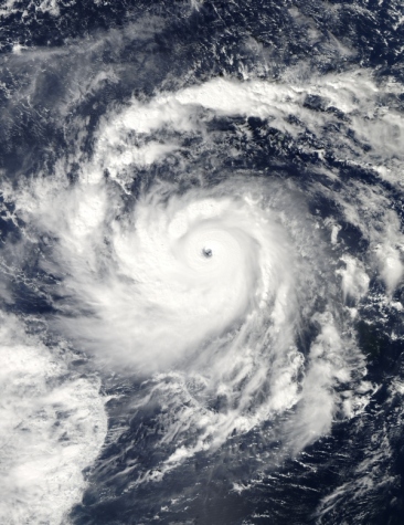
onweer-online
Weer of geen weer, altijd actueel www.onweer-online.nl
doe maar nietquote:
Gaat lekker
| Wordfeud: marcel-o |plug.dj/uptempo |<-- draai zelf je platen

quote:Nida was strengthening to a super typhoon near Guam when the Moderate Resolution Imaging Spectroradiometer (MODIS) on NASA’s Aqua satellite captured this true-color image on November 25, 2009. MODIS acquired this image 1:55 p.m. local time (03:55 UTC). In the six-hour time span during which this picture was taken, Nida strengthened from a category 3 typhoon to a category 4 super typhoon. On November 25, Unisys Weather reported that Nida had maximum sustained winds of 150 knots (280 kilometers per hour) with gusts up to 180 knots (335 kilometers per hour).
leuk stukje informatie

rest van het artikelquote:Living on an island in the balmy tropics of the western Pacific, the residents of the Philippines are accustomed to tropical storms. The storms can form at any time of the year, and they frequently impact the island nation as they track west across the Pacific. This image illustrates how much rain the Philippines received from tropical cyclones between May and October in 2009. In that period, 12 named storms poured heavy rain over the Philippines. Two storms, Ketsana and Parma, brought unusually heavy flood-inducing rain within a two-week span at the end of September and early October. The two storms alone left at least 460 people dead.
Inorbit: zeg dat dan typluie triangeljosti
Beauregard: Een beetje FOK!ker laat het brood door z'n moeder smeren.
Ecosia
ek's 'n flash drive, jy's 'n floppy
Beauregard: Een beetje FOK!ker laat het brood door z'n moeder smeren.
Ecosia
ek's 'n flash drive, jy's 'n floppy
Komt die naar ons toe?  kommah kommah
<a href="https://www.youtube.com/channel/UCPueUwKfPaGH7v48LZlltkg" rel="nofollow" target="_blank">WSDokkum Youtube</a>
Cleo vormt (nog) geen bedreiging. Het is nu een cat. 3 met een windveld van 185 km/uur en windstoten tot 230 km/uur.

quote:Forecasts 2010
An early forecast for 2010 calls for an “above-average” hurricane season, according to the Tropical Meteorology Project at Colorado State University.
The team expects 11 to 16 named storms, 6 to 8 hurricanes and 3 to 5 major hurricanes — ones with sustained winds of 111 mph or greater.
Today’s prediction marks the first time William Gray’s team at CSU has provided a range of storms in its December early season forecast. The report is the team’s 27th year of hurricane seasonal predictions.
Because the report is based on Atlantic basin conditions, the team says its forecast could change substantially by the start of the hurricane season, which runs on June 1 to Nov. 30.
Gray’s team plans to list specific numerical forecasts in its next forecast on April 7.
“The Atlantic basin has the largest year-to-year variability of any of the global tropical cyclone basins,” Phil Klotzbach, the team’s leader, said in a release.
A weakening El Nino will allow more hurricanes to form, the team predicts. El Nino is a pattern of warmer-than-usual water in the Pacific Ocean, near the equator. The pattern creates more wind shear over the Atlantic, which breaks up tropical storms as they form.
“We anticipate the current El Nino event to dissipate by the 2010 hurricane season,” Gray said in the release, “and warm sea surface temperatures are likely to continue being present in the tropical and North Atlantic during 2010 — conditions that contribute to an above-average season.”
Their forecast is based on a statistical prediction scheme that uses 58 years of “hindcast” data. Over that time period, the scheme correctly forecasted above- or below-average seasons in 44 out of 58 years, the team said.
For the 2010 Atlantic basin hurricane season, the CSU hurricane forecast team expects:
*A 64 percent chance that at least one major hurricane will make landfall on the U.S. coastline in 2010. The long-term average probability is 52 percent.
*40 percent chance (the long-term average is 31 percent) of a major hurricane making landfall along the U.S. East Coast, including the Florida Peninsula.
*A 40 percent chance (the long-term average is 30 percent) of a major hurricane making landfall along the Gulf Coast, from the Florida Panhandle west to Brownsville.


Zo dan, dat gaat nog lekker zeg
<a href="https://www.youtube.com/channel/UCPueUwKfPaGH7v48LZlltkg" rel="nofollow" target="_blank">WSDokkum Youtube</a>
speedyquote:
Dat is je pier linkquote:WARNING: ProxyAV has detected a virus/PUS in this
file!
File has been dropped.
2009-12-14 09:15:52+01:00CET
ProxyAV (Version 3.2.3.1(39265)) - http://www.BlueCoat.com/
Antivirus Vendor: Kaspersky Labs
Scan Engine Version: 8.0.1.23
Pattern File Version: 091214.055900.3364740 (Timestamp: 2009.12.14 05:59:00)
Virus/PUS: "Trojan.JS.Agent.awm" found!
www.weerstation-holwerd.nl
[ Bericht 6% gewijzigd door Jumparound op 16-12-2009 09:06:26 ]
Inorbit: zeg dat dan typluie triangeljosti
Beauregard: Een beetje FOK!ker laat het brood door z'n moeder smeren.
Ecosia
ek's 'n flash drive, jy's 'n floppy
Beauregard: Een beetje FOK!ker laat het brood door z'n moeder smeren.
Ecosia
ek's 'n flash drive, jy's 'n floppy


quote:Tropische cycloon Laurence stormt af op West-Australië
De tropische cycloon Laurence zet met een snelheid van 230 kilometer per uur koers naar de kust van Kimberly in West-Australië. Het is de eerste cycloon van het seizoen die de Australische deelstaat bedreigd. Bewoners van de kust hebben de raad gekregen om zich voor te bereiden op de cycloon.
De tropische storm bevindt zich momenteel op 55 kilometer ten noorden van Kuri Bay en 155 kilometer ten noordoosten van Cockatoo Island. Verwacht wordt dat ze vandaag het eiland en de Koolaneilanden bereikt met windstoten van honderd kilometer per uur. De hevige wind zal volgens de laatste voorspellingen ook gepaard gaan met stevige buien.
De bewoners van de eilanden hebben de raad gekregen om zich voor te bereiden op de storm. De plaatselijke luchthaven wordt alvast gesloten en de aboriginalgemeenschap in Oombulgurri sluit ook haar deuren. Laurence onstond zondag boven de Timorzee en is in kracht toegenomen van categorie één naar categorie vier.
quote:Vier doden door cycloon Mick op de Fiji's
Zware onweders hebben op de Fiji Eilanden in de Zuidzee enorme schade aangericht. Minstens vier mensen zijn om het leven gekomen, toen cycloon Mick gisteren met topsnelheden van 150 kilometer per uur over de eilanden raasde. Dat deelden de media vanuit de hoofdstad Suva mee. Meer dan 2000 mensen vluchtten weg uit hun beschadigde huizen.
Mick was de eerste zware wervelstorm van het zomerseizoen op het zuidelijk halfrond. De stroomvoorziening was op vele plaatsen onderbroken en vele wegen overstroomden en waren niet meer toegankelijk. Op het eiland Yasawa werd een toeristisch complex aan het strand zwaar beschadigd. De ongeveer 60 gasten moesten vluchten naar een speciaal voor onweders gebouwd noodverblijf.
Niemand raakte gewond, zei een woordvoerster op de Nieuw-Zeelandse radio. De meeste toeristen op Fiji komen uit Australië en Nieuw-Zeeland. (afp/adb)
hln
quote:Red alert as cyclone heads for mainland
Cyclone Laurence has altered direction and is headed directly for the West Australian mainland.
The category 5 system was tracking parallel to the coast but has now angled southwards and is predicted to move onshore by nightfall, about 100 kilometres north-west of Derby.
The small but very intense cyclone crossed over the pearling community of Kuri Bay early this morning and was threatening the iron ore operations of Cockatoo and Koolan islands where staff have relocated to a cyclone shelter.
The Fire and Emergency Service Authority's Gordon Tiddums says Kuri Bay was relatively unscathed.
"Really there's no damage, just trees down. They've had some strong gusts of wind but no buildings destroyed," he said.
The Bureau of Meteorology is warning residents along the West Kimberley coast to prepare for very destructive winds and heavy rains tonight.
It says the communities of Koolan Island and Cockatoo Island are on red alert and need to go to shelter immediately.
A yellow alert applies for Cape Leveque, One Arm Point, Djarindjin, Lombadina and Derby.
Cyclone Laurence has already brought heavy rains and destructive winds to communities and cattle stations across the north Kimberley.
Linda Pearson from Theda Station says they have had 175 millimetres of rain in the past 24 hours and she expects to be stranded for several days.
"We've just had a very heavy storm. You can't go anywhere, literally, because the water on the roads is too deep," she said.
"We've got water above our lawns, our septic tanks are flooding, our roads are now rivers and our driveway is a river."


quote:Emergency crews in Western Australia are preparing to assess the damage from Tropical Cyclone Laurence at first light.
Laurence has been downgraded to a category 3 system after leaving a trail of damage across Western Australia's north.
The cyclone was a category 5 when it crossed the Pilbara coast at 80 Mile Beach yesterday afternoon, causing significant damage to some buildings.
There have been no reports of injuries, but emergency services say they have not been able to contact some people due to disruptions to phone services.
The Fire and Emergency Services Authority's (FESA) Les Hayter says a helicopter will this morning conduct an aerial assessment of the coastline.
"At the moment we're having trouble contacting people in Wallal and Mandora and we just want to make sure that the reports we are currently getting that there is no loss of life or damage to humans is correct." he said.
"There is obviously some fairly substantial damage at 80 Mile caravan park which we will be able to see at first light with this crew coming through with the helicopter."
At 3:30 am (AWST) Cyclone Laurence was about 100 kilometres south-south-east of Wallal moving at 11 kilometres per hour.
Although Laurence is expected to gradually weaken today, very destructive winds are still possible this morning as the cyclone moves further inland.
FESA says people in or near communities from Sandfire to Pardoo and inland to Yarrie and Marble Bar remain on red alert.
But people in communities between De Grey, Port Hedland and Bidyadanga have been advised that wind dangers have passed.
Emergency crews will be unable to respond to requests for help until red alerts are lifted.

Hij ziet er nog behoorlijk krachtig uit terwijl hij al een flink stuk landinwaarts was getrokkenquote:Cyclone Laurence had moved far inland over Western Australia by the time the Moderate Resolution Imaging Spectroradiometer (MODIS) on NASA’s Terra satellite captured this image 10:15 a.m. local time on December 22, 2009. The storm had come ashore late the previous afternoon, battering the coast with destructive winds that damaged structures along Western Australia’s northern coast.
Though still a formidable storm, Laurence was clearly weakening when this image was acquired. The storm no longer had a visible eye, as it did on December 21, nor did it have its previous compact circular shape. The bands of clouds that spiraled around the center of the storm were more spread out, indicating that the storm was losing its circulation after being cut off from the warm water that fueled it. Despite all this, Laurence still had the distinctive shape of a tropical cyclone in this image.
Laurence damaged buildings and cut power and phone lines in Western Australia, said the Sydney Morning Herald. No injuries or deaths had been reported as of December 23