WKN Weer, Klimaat en Natuurrampen
Lees alles over het onstuimige weer op onze planeet, volg orkanen en tornado's, zie hoe vulkanen uitbarsten en hoe Moeder Aarde beeft bij een aardbeving. Alles over de verwoestende kracht van onze planeet en tal van andere natuurverschijnselen.


Een drie zelfsquote:Op zaterdag 15 augustus 2009 18:00 schreef Co_OL het volgende:
En de tweede is er nu ookzo te zien word dat een cat2
[ afbeelding ]
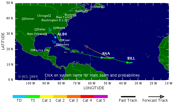
Er komt er misschien dus nog één achteraanquote:ANA, BILL AND 91L ALL KEEPING US PLENTY BUSY
There is quite a lot going on tonight as the tropics have sprung to life in grand fashion. We have TS Ana, TS Bill and now 91L in the eastern Gulf of Mexico- plus a new tropical wave off of Africa that could develop over the next few days.
First, let's discuss the system in the Gulf. It is in association with a tropical wave that we have tracked for the last week or so. It is now trying to flare up in a small area just to the west of Florida. Tampa radar can clearly see a counter-clockwise spin to the feature out over the open Gulf. Hopefully it will move inland later tomorrow or Monday before much more organization can take place. But, let's remember Humberto two years ago off the Texas coast. It was small and was able to ramp up very quickly. Do not be suprised to see this do something similar- perhaps not that dramatic but there is a chance that this becomes a tropical depression or even a tropical storm before reaching the coast along the Florida Panhandle or nearby. We'll watch it closely and people visiting/living in the area need to be ready for a quick change to the weather as this system comes rolling in. It will have squally weather with gusty winds and rough seas. It will be interesting to see what the NHC says about it tomorrow morning.
Meanwhile, Ana is struggling to keep its existence going against dry air and a fairly quick forward pace. Odds favor this one falling short of its potential which is great news for areas to its west. This is not say that nothing will happen but the intensity forecast is looking better with each update. Still, people in the northern Leewards through Puerto Rico and Hispaniola should pay close attention to the future progress of Ana. Remember- rain fall can be deadly if too much falls too soon or over terrain that cannot handle it.
Bill continues to demonstrate to us that it will become a powerful hurricane over the next few days. It is large and steadily getting better organized over the deep tropical Atlantic. The latest forecast suggests more good news for the islands of the NE Caribbean as Bill should pass by to the north and east. The models are trending towards a more northwesterly course towards the five day time period. How much so and then what happens after that remains to be seen. Obviously, we will keep up with the latest model runs to see what guidance they can provide.
Farther east and off the west coast of Africa we are monitoring another tropical wave with potential for development as it too moves west. Things will be quite busy over the next several days with a lot of information coming out of many sources.
Hmm ik ga woensdag landen op Cuba en dan is tropische storm ANA daar precies, weet iemand hoe dat zit met landen als er zulk slecht weer is?
Het is een tussenstop naar mexico
Het is een tussenstop naar mexico
Drugs are good mkay?
Bill kan wel eens een hele grote hurricane gaan worden.. Cat. 3 of 4 is niet uit te sluiten. Zelfs 5 is mogelijk, maar dat is maar 2%.
's Avonds een man, overdags rustig an
Ana duikt de Golf van Mexico ook nog in. Het water is daar meer dan 30 graden. Ik ben benieuwd of ie daar nog gaat aansterken.
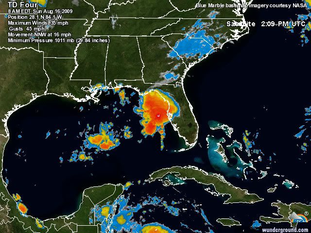
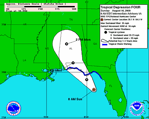
quote:Tropical Depression 4 (35 mile per hour winds) developed from an area of low pressure off of Florida's West Coast early this morning. As of 8 a.m. Sunday morning, T.D. 4 was located about 125 miles south-southeast of Apalachicola, Florida. It is forecast to become a tropical storm later today (at which time it would become Tropical Storm Claudette), and make landfall late this afternoon or this evening.
Tropical storm warnings extend from the Alabama/Florida border eastward to the Suwannee River, Florida. This means that tropical storm conditions are expected somewhere in this area within the next 24 hours.
Heavy rain, locally 3 to 5 inches or more, is possible over the Florida Panhandle over the next 24 to 36 hours, with heavy rain spreading inland across portions of the Southeastern U.S. over the next couple of days.
Bill wordt een monster. Ana gaat hopelijk kracht winnen in de Golf van Mexico. Spektakel gegarandeerd.
Nu al veel overlast in V.S. door Claudette. Heel veel regen.
Nu al veel overlast in V.S. door Claudette. Heel veel regen.
's Avonds een man, overdags rustig an

Leuk plaatje idd, kunnen we wel gebruiken, maar is het geen fictie/photoshop?
Om welke orkanen zou het hier gaan en wanneer dan? Of is dit een plaatje van 3 orkaantjes Andrew in één?
Om welke orkanen zou het hier gaan en wanneer dan? Of is dit een plaatje van 3 orkaantjes Andrew in één?

Dat laatste; zie ook de titel van die afbeelding.quote:
Leuk plaatje idd, kunnen we wel gebruiken, maar is het geen fictie/photoshop?
Om welke orkanen zou het hier gaan en wanneer dan? Of is dit een plaatje van 3 orkaantjes Andrew in één?
Om vervolgens door te reizen via het kanaal op naar NL om daat een leuk stormpje en water te gevenquote:Op maandag 17 augustus 2009 17:07 schreef Burnie88 het volgende:
Wel jammer dat Bill afbuigt naar het noordwesten...
Haha, ja windkracht 7 en een zondagmiddag regen. Ik wil dat ding in de mexicaanse golf zien gaan en uit zien groeien tot een snoeiharde cat. 5quote:Op maandag 17 augustus 2009 18:37 schreef Co_OL het volgende:
[..]
Om vervolgens door te reizen via het kanaal op naar NL om daat een leuk stormpje en water te geven
Maar het seizoen is wel echt begonnen nu. Ik hoorde dat er al weer een 4e stormfront zat aan te komen?
's Avonds een man, overdags rustig an

jij hebt liever dood en verderf in de Dominicaanse Republiek, Haiti en vervolgens Florida?quote:
Wel jammer dat Bill afbuigt naar het noordwesten...
Vind ik wel spectaculair ja. En ik ben niet de enige op dit topic die er zo over denkt denk ik.. Hoe extremer de storm, hoe mooier om te volgen. Is ook met tornado-outbreaks enz. het geval.quote:Op maandag 17 augustus 2009 19:53 schreef Frutsel het volgende:
[..]
jij hebt liever dood en verderf in de Dominicaanse Republiek, Haiti en vervolgens Florida?
Maar uiteraard zijn slachtoffers nooit 'gaaf' of 'mooi'.
[ Bericht 7% gewijzigd door Burnie88 op 17-08-2009 22:45:14 ]
's Avonds een man, overdags rustig an

Is er eigenlijk ooit in de geschiedenis een orkaan in Nederland voorgekomen? Als dat überhaupt mogelijk is  .
.
quote:Op maandag 17 augustus 2009 22:35 schreef 0100 het volgende:
Is er eigenlijk ooit in de geschiedenis een orkaan in Nederland voorgekomen? Als dat überhaupt mogelijk is
knmiquote:Orkaankracht 12 wordt in ons land zelden bereikt en als het gebeurt dan heeft de wind meestal maar korte tijd die enorme kracht. De laatste keer dat op een enkele plaats aan onze kust eventjes windkracht 12 is gemeten was 16 december 1979. Ook in de nacht van 2 op 3 januari 1976 werd in IJmuiden windkracht 12 gemeten, maar toen is op verscheidene andere plaatsen enkele uren achtereen een gemiddelde windsnelheid van 115 km/u gemeten, net iets onder orkaankracht. Op 7 september 1944 registreerde Vlissingen gemiddeld over een uur een windsnelheid van 122 km/u. Voor zover bekend is dat de enige storm geweest ooit, waarin de windmeter geruime tijd op windkracht 12 stond.