WKN Weer, Klimaat en Natuurrampen
Lees alles over het onstuimige weer op onze planeet, volg orkanen en tornado's, zie hoe vulkanen uitbarsten en hoe Moeder Aarde beeft bij een aardbeving. Alles over de verwoestende kracht van onze planeet en tal van andere natuurverschijnselen.


Hier is dan het eerste deel van Hurricane Season 2009 voor alle tropische stormen ter wereld. Voor zowel Atlantische, Indische als Pacifische stormen kan je hier terecht
Algemene Info
Met de term 'Hurricane Season' bedoelden we in eerste instante de periode van 1 juni tot 30 november.
Deze periode wordt in het Atlantische basin en de Golf van Mexico gezien als het Stormen-seizoen. Echter komen deze geweldadige stormen overal in de wereld voor en met name in Azië zorgen ze jaarlijks voor duizenden slachtoffers en tienduizenden daklozen. Echter horen we vaak erg weinig over de stormen in Azië en juist meer over die in de VS.
In de laatste jaren zijn Tropische Stormen meer en meer in de media gekomen. Het lijkt ook alsof ze meer en meer slachtoffers maken. Een documentaire over Hurricane Andrew uit 1992, heeft diepe indruk gemaakt en ook zullen kenners orkanen Floyd, Gilbert, Stan en Ivan zich zeker nog herinneren. De catastrofe die "Katrina" met zich meebracht ging de hele wereld over. En dan praten we eigenlijk alleen over de Atlantische stormen en lijken we te vergeten dat er in 2007 meer dan 4000 doden vielen in Bangladesh door orkaan Sidr en orkaan Nargis zorgde voor 80.000 doden in Myanmar alleen al.
Hoewel het Atlantische seizoen pas officieel in juni begint zijn er op andere plekken in de wereld zeker meer orkanen te vinden in de komende maanden. We zullen ook deze dus zeker gaan bespreken. Waarschijnlijk zal de kern van de discussie en de posts gaan over de periode 1-6-2008 t/m 30-11-2008. T.z.t. zal er ook wel een NWS-topic worden geopend als een orkaan ook uitgebreid in het nieuws komt.
Orkanen: Hoe ontstaan ze eigenlijk?
op de site van Wikipedia kan je in het Nederlands nalezen hoe ze ontstaan en wat de belangrijkste energiebron is voor hun verwoestende kracht: het warme zeewater
Ook de BBC heeft er een interessante en leuke animatie over gemaakt.
Ook wordt er op LiveScience in het engels prima uitgelegd hoe ze ontstaan en zich ontwikkelen
Indeling en Kracht
De stormen worden ingedeeld op 'categorie'. Vaak zijn het eerst tropische stormen" (Tropical Depression, Tropical Storms), die overgaan op Orkaanstatus (Hurricane/Tyfoons) Ze worden ingedeeld op windsnelheden via de Saffir-Simpson Schaal
Tropical Depression 24-38 mph winds (38-61 km/u)
Tropical Storm 39-73 mph winds (62-118 km/u)
Hurricane Categorie 1 74-95 mph winds (119-153 km/u) -- 4/5 ft Storm Surge -- Vb. Danny 1997, Stan 2005
Hurricane Categorie 2 96-110 mph winds (154-177 km/u) - 6/8 ft Storm Surge -- Vb. Danielle 2004
Hurricane Categorie 3 111-130 mph winds (178-209 km/u) - 9/12 ft Storm Surge - Vb.Fran 1996, Beta 2005
Hurricane Categorie 4 131-155 mph winds (210-249 km/u) - 13/18 ft Storm Surge - Vb.Hugo 1989, Frances 2004
Hurricane Categorie 5 > 156 mph winds (meer dan 250 km/u) -- 18ft or more S.S. -- Vb.Andrew 1992, Mitch 1998 en Wilma, Katrina 2005
TIP: Interactief (film0overzicht van de krachten van orkanen nav de schaal van Simpson
Waarom hebben orkanen namen?
De Tropische Depressies worden overal ter wereld in de gaten gehouden en zodra de depressies uitgroeien tot orkaan of cycloon, wordt er een naam aan de storm gegeven. Sinds 1950 krijgen ze namen op alfabetische volgorde (met uitzondering van de letters Q, U, X, Y en Z). Mocht een orkaan vernietigend hebben huisgehouden zoals Floyd, Gilbert en bijv. Katrina, dan zal die naam worden vervangen. Soms komt het ook voor dat alle letters van het alfabet gebruikt zijn in één seizoen (zoals 2005), dan zal een volgende storm Alpha gaan heten, gevolgd door Beta etc etc. Voor het orkanenseizoen 2009 zijn de namen als volgt:
Atlantische Stormen 2009
Ana, Bill, Claudette, Danny, Erika, Fred, Grace, Henri, Ida, Joaquin, Kate, Larry, Mindy, Nicholas, Odette, Peter, Rose, Sam, Teresa, Victor, Wanda
In het Noordoosten van de pacific ontstaan ook orkanen. Deze zorgen meestal voor weinig schade aan de Amerikaanse/Mexicaanse westkust.
Oost Pacifische Stormen 2009
Andres, Blanca, Carlos, Dolores, Enrique, Felicia, Guillermo, Hilda, Ignacio, Jimena, Kevin, Linda, Marty, Nora, Olaf, Patricia, Rick, Sandra, Terry, Vivian, Waldo, Xina, York, Zelda
Verder zijn er dan nog de stormen in het Noorden, Zuiden en Westen van de Pacific. Daar worden ze tyfoons en/of cyclonen genoemd. Met name de stormen in het Noord/Westen komen vaak in het nieuws omdat ze Japan, de Filipijnen, Taiwan en China vaak teisteren, maar ook geheel Zuid Oost Azie kunnen treffen. Meer informatie over de namen van deze stormenvind je hier.
Leuk hoor, maar wanneer zijn die orkaanseizoenen nou precies?
ATLANTISCHE OCEAAN: 1 juni t/m 30 november
NOORD OOST PACIFIC:Begin mei t/m begin November, met piek in Augustus/September
NOORD WEST PACIFIC: Begin juli t/m eind November, maar eigenlijk hele jaar door aktiviteit.
NOORD INDISCHE OCEAAN: April t/m December met pieken in Mei en November
ZUID INDISCHE + WEST AUSTRALISCHE OCEAAN: Oktober t/m Mei met pieken in Februari en April
ZUID WEST PACIFIC + OOST AUSTRALISCHE OCEAAN: Oktober tot eind April met piek in Februari.
Over het algemeen is Mei de rustigste maand en September de zwaarste.
Ennuh, hoe ziet die voorspelling er voor 2009 dan uit?
50 jaar Hurricane Seizoen hebben een gemiddeld orkaanseizoen gecreëerd. 9,6 stormen krijgen een naam, 5,9 stormen groeien uit tot orkaan en 2,3 orkanen worden superorkanen.(cat 4/5)
Volgens Phil Klotzbach en William Gray van CSU wordt 2009 een relatief druk orkaanseizoen. Volgens hun is er 63 procent kans dat een superorkaan in 2009 de VS kust zal treffen. Meer over de voorspelling voor 2009 en die van 2008 kan je hier lezen
Oude Delen
2004 - Deel 1 en Deel 2
2005 - Deel 1 en Deel 2
2006 - Deel 1 en Deel 2
2007 - Deel 1, Deel 2, Deel 3 en Deel 4
2008 - Deel 1 en Deel 2
Enkele Links
1. National Hurricane Centre
2. Carribean Storm Network
3. Hurricanezone
4. Hurricane Track
5. Website met satelietbeelden van de Caribbean en de rest van Amerika
6. Intellicast: Geavanceerde satellietfoto's en gifs van aktuele stormen
7. Tropical Weather Underground
8. Tropical Storm Risico's van dit moment
9. Wikipedia Hurricanes/Tyfonen in het algemeen
10. Alle stormen ter wereld van de laatste jaren in overzicht
11. The StormTrack
12. Orkanensite in de Filipijnen
13. Atlantische Orkanensite
14. Actuele orkanen in Australië en De orkaanindeling in Australië
15. Tropische weersite omgeving Australië
16. Mooie site over Orkanen aan de VS kusten
17. Website van NASA over Hurricanes
Opmerkelijke Wikipedia-Links
-- Hurricane Katrina 2005
-- Cyclone Nargis 2008
-- Hurricane Season 2008 - Wikipedia
-- Hurricane Season 2007 - Wikipedia
-- Hurricane Season 2006 - Wikipedia
-- Hurricane Season 2005 - Wikipedia
-- Hurricane Season 2004 - Wikipedia
Actuele Weerradar in Golf van Mexico

Actuele Water temperatuur.
=====================
Post hier je gegevens, berichten, data en opmerkelijke zaken over Orkanen, Tyfoons en Hurricanes en van 2009
[ Bericht 0% gewijzigd door Frutsel op 27-08-2009 12:10:19 ]

Nu wel, thxquote:Op maandag 12 januari 2009 22:49 schreef aloa het volgende:
Staat deze site er ook tussen?
Current Tropical Cyclones Australie
Onderstaande link is ook wel handig. In Australie gebruiken ze weer een andere indeling, dan in Amerika of Azie.
categorie/indeling
categorie/indeling

Madagascar wordt weer flink blank gezet
twee van die krengen
[ Bericht 26% gewijzigd door Frutsel op 19-01-2009 15:05:57 ]
Veel schade in Madagascar door Fanele.
Overstromingen en enorme stormschade.
Overstromingen en enorme stormschade.
quote:TROPICAL STORM "ERIC"
Tropical storm "Eric" descended on the regions of Sofia, Sava, Atsinanana, and Analanjirofo in the north-east of Madagascar at 8 am on 19 January 2009, carrying heavy rain and winds at the speed of up to 95 km/h. Landing in the district of Fenerive-Est, "Eric" edged southwards through the districts of Fenoarivo Atsinanana, Sainte-Marie, Vavatenina, Ambositra, Toamasina I, Antsohihy, Mampikony, and Mandritsara,veering off into the Indian Ocean by 2 pm.
According to the preliminary reports received from regional authorities through BNGRC, approximately 1,000 persons remain homeless with another 1,700 persons impacted to varying degrees by the tropical system. BNGRC reports one person dead and 24 injured
Unconfirmed damage has been reported in the agricultural sector: flooded rice paddies, fallen banana trees, destroyed manioc plantations and other vital crops. Some stretches of national roads have been flooded by swollen rivers, making communication difficult and in some cases suspended. Several public buildings, including schools, have been reported damaged to varying degrees.
CYCLONE "FANELE"
Fanele was a type 4 cyclone, descending on the south-east of Madagascar at 4 am on 21 January 2009. Moving through the district of Morondava, some 50 km south of the town of Morondava, the system brought in winds travelling at 150 km/h, reaching in gusts the speed of 210 km/h. Later that day, "Eric" moved south-east, crossing the regions of Menabe, Atsimo-Andrefana, Haute Matsiatra, and Ihorombe, exiting Madagascar on 22 January at 2 am through the regions of Anosy and Atsimo Atsinanana. The arrival of the cyclone was preceded by heavy rainfall threatening the inhabitants of the town of Morondava and the district of Miandrivazo with the prospect of flooding.
Preliminary reports issued by BNGRC's mobile teams dispatched to the impact areas point to over 9,000 persons displaced in the district of Miandrivazo due to flooding. A number of public buildings in the town of Morondava have suffered varying degrees of damage, including the municipal water system which has been reported down. Homeless persons are being assembled in temporary shelter areas under the supervision of the Malagasy Red Cross.
As rapid assessment missions are being dispatched to the impacted areas, more accurate picture of the extent of damage will become available in the next days.
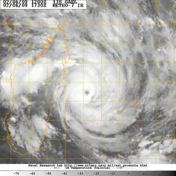

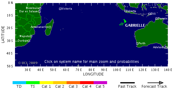
Tropical Cyclone Gael
Tropical Cyclone Gael brushed the islands of Mauritius and Réunion on its westward trek through the southern Indian Ocean in early February 2009. On February 7, the storm hit Category 4 cyclone strength, with sustained winds of 120 knots (138 miles per hour), as it approached the east coast of Madagascar. This image from the Moderate Resolution Imaging Spectroradiometer (MODIS) on NASA’s Terra satellite shows the storm that day, before it veered away from land and headed northeast.

Tropical Cyclone Gael brushed the islands of Mauritius and Réunion on its westward trek through the southern Indian Ocean in early February 2009. On February 7, the storm hit Category 4 cyclone strength, with sustained winds of 120 knots (138 miles per hour), as it approached the east coast of Madagascar. This image from the Moderate Resolution Imaging Spectroradiometer (MODIS) on NASA’s Terra satellite shows the storm that day, before it veered away from land and headed northeast.
Inmiddels is Hamish een categorie 4
(volgens de schaal in Australie een cat 5)
(volgens de schaal in Australie een cat 5)
quote:Brutal winds as Hamish reaches Cat 5
Cyclone Hamish has now intensified into a Category 5 system, creating winds in excess of 280 kilometres an hour, off the north-east coast of Queensland.
Residents and tourists are preparing to ride out the effects of the cyclone as it moves along the coast.
The outer edge of the massive storm, already 40km/h faster than Cyclone Larry which smashed Innisfail in 2006, will lash islands in the Whitsundays in the next few hours.
It continues moving south-east off the coast, and some islands in its path have been evacuated.
A Category 5 is rated as extremely dangerous and can cause widespread destruction.
Director of the Bureau of Meteorology, Jim Davidson, says the cyclone will bring winds up to 180 kilometres an hour to islands in the Whitsundays.
"If it comes a little closer the damage will be much worse," he said.
Mr Davidson says it will stay at least 200 kilometres off the coast.
"And even if a Category 5 cyclone is that far out, it shouldn't be a serious problem," he said.
Emergency warning signals have been sounded in communities from Bowen to Mackay, but the biggest concern is for islands in the Whitsundays.
Gold Coast man Dan Riddle is on his honeymoon on Hamilton Island, and he and his wife have stocked up on food and water.
"We don't really know what to expect but I guess a heap of rain and bit of wind," he said.
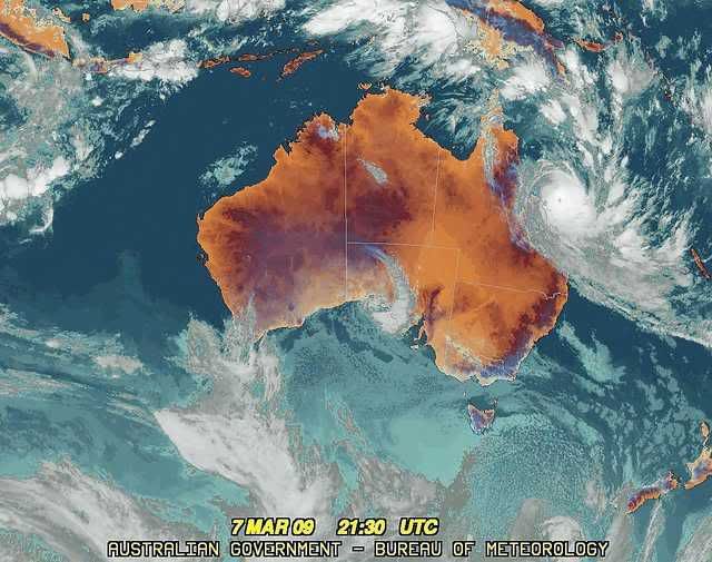
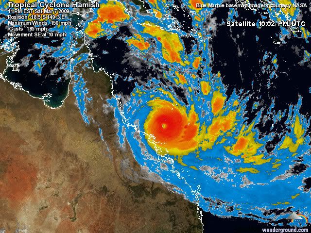

quote:With winds near 130 knots (150 miles per hour), Tropical Cyclone Hamish was a powerful Category 4 storm (on the Saffir-Simpson Scale) as it paralleled the northeast coast of Australia at the end of the first week of March 2009. Initial predictions were that the storm would weaken and come ashore just north of Brisbane on March 9, but instead, the storm veered more east than south, drawing the eye of the still-powerful storm away from land.
This image of Hamish was captured by the Moderate Resolution Imaging Spectroradiometer (MODIS) on NASA’s Aqua satellite on March 9, 2009 at 3:30 Universal Time Coordinated. The storm was compact, with a ring of towering of thunderclouds surrounding the cloud-filled eye. A few hours before this image was taken, Hamish had maximum sustained winds near 110 knots (127 mph), with gusts up to 135 knots (155 mph). Northwest of the storm, the waters around the Great Barrier Reef were bright turquoise, a sign that winds and waves had churned up sediment.
Although the risk of a direct landfall had lessened, the dangers from strong winds and flooding from heavy rainfall and storm surges remained. Thousands of residents of low-lying coastal communities north of Brisbane evacuated their homes, and forecasters warned that the storm’s path and intensity would remain uncertain until Wednesday.
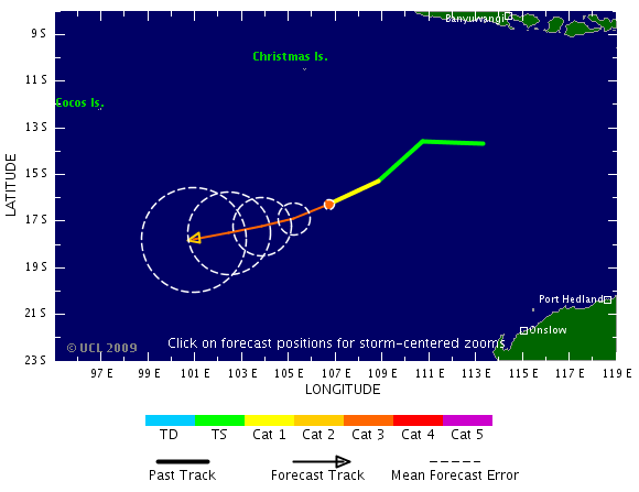
Hamish is precies langs de oostkust van Australie gezakt. Steeds rond de 200 km uit de kust.
Er bestaat een kans dat ie toch nog landfall gaat maken.
Er bestaat een kans dat ie toch nog landfall gaat maken.
quote:"It's running into an upper jet stream that wants to rip the top off the cyclone and push it out to the east," he said.
"But the high in the Tasman with the easterly flow is trying to push the lower half of the cyclone back towards the coast.
"Now that's going to weaken the cyclone and it depends on how much it's weakened by that interaction as to how much is left of the system."
Authorities say the next 24 hours will be the crucial period to see if Hamish turns back closer to the coast.
Mike Shapland from Emergency Management Queensland says it remains unclear what the storm will do.
Mr Shapland says it appears the threat has eased for now but it remains unclear what the storm will do.
"I think we've got a fairly clear space for the next 24 to 48 hours if the bureaus track and estimations come right," he said.
"But really what happens after Wednesday is the question in our minds."

Minder actief hurricaneseizoen verwacht
quote:De eerste verwachtingen voor het Atlantisch orkaanseizoen zien er gunstig uit. In de Atlantische Oceaan en de Caribische Zee worden dit jaar minder tropische orkanen verwacht dan de afgelopen jaren.
Ook in de westelijke Stille Oceaan, dus voor de westkust van Mexico en de VS, worden dit jaar minder tropische cyclonen verwacht. Het Atlantisch orkaanseizoen duurt van juni tot december. De verwachting van de orkaanactiviteit is afkomstig van het Europees Weercentrum ECMWF en geldt voor de eerste helft van het seizoen.
Het geringere aantal tropische stormen en hurricanes hangt onder meer - en op een ingewikkelde manier - samen met La Niña. In een La Niña-jaar - met tijdens het hurricane-seizoen relatief koud zeewater langs de evenaar - ontstaan doorgaans meer hurricanes. Dat houdt verband met de wind op grote hoogte die dan minder sterk is, waardoor de enorme wolkencomplexen zich tot hoog in de atmosfeer kunnen ontwikkelen.
Het ziet er echter naar uit dat de La Niña van de afgelopen periode komende zomer verleden tijd is. Volgens de verwachtingen blijven de temperaturen langs de Afrikaanse westkust, waar de stormen ontstaan, echter voorlopig nog laag. Door dat naijleffect kunnen tropische stormen en hurricanes zich komende zomer moeilijker vormen.
Dat betekent niet dat er hier helemaal geen orkanen zullen langskomen. Normaal telt een seizoen tegenwoordig zo'n 12 tot 16 tropische stormen waarvan er 5 à 10 het orkaanstadium bereiken. Bovendien zeggen de prognoses niets over de schade die ze kunnen aanrichten. Op deze termijn is niet aan te geven hoeveel orkanen land bereiken en hoe zwaar ze worden.
Vorig jaar was bijzonder. In totaal ontstonden er 8 orkanen, waarvan er liefst 6 het vasteland van de Verenigde Staten bereikten, terwijl er 5 uitgroeiden tot een zware orkaan van de hoogste categorieën. Recordjaar is 2005 toen het Atlantisch gebied 14 hurricanes zag passeren.
Bron: KNMI (vwk)

Tropical Cyclone Ilsa was heading west-southwest in the Indian Ocean on March 20, 2009, when the Moderate Resolution Imaging Spectroradiometer (MODIS) on NASA’s Terra satellite captured this image. Ilsa reached Category 3 strength on March 19, but as of March 20, has weakened to Category 2.
Pff...al de zoveelste storm dit jaar die daar de boel lam legtquote:Op dinsdag 7 april 2009 15:08 schreef buachaille het volgende:
Tropische storm Jade heeft huisgehouden in Madagascar.