WKN Weer, Klimaat en Natuurrampen
Lees alles over het onstuimige weer op onze planeet, volg orkanen en tornado's, zie hoe vulkanen uitbarsten en hoe Moeder Aarde beeft bij een aardbeving. Alles over de verwoestende kracht van onze planeet en tal van andere natuurverschijnselen.


IJsdammen...quote:In delen van de Amerikaanse staat Noord-Dakota is de noodtoestand uitgeroepen vanwege hoogwater. Het gebied wordt geteisterd door zware overstromingen als gevolg van onophoudelijke regenval. Verder dreigt de Missouri buiten haar oevers te treden.
Wegen en bruggen in het gebied zijn al afgesloten en duizenden vrijwilligers zijn in de weer met zandzakken om de dijken te verstevigen.
Mensen in laaggelegen gebieden zijn geëvacueerd. Ook 146 gevangenen in de hoofdstad Bismarck van Noord-Dakota moesten naar een andere plaats worden gebracht.
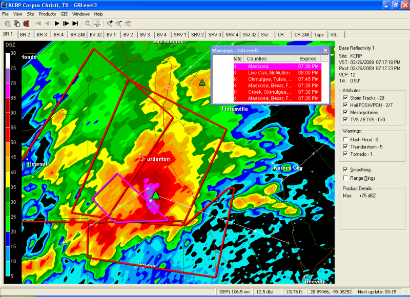
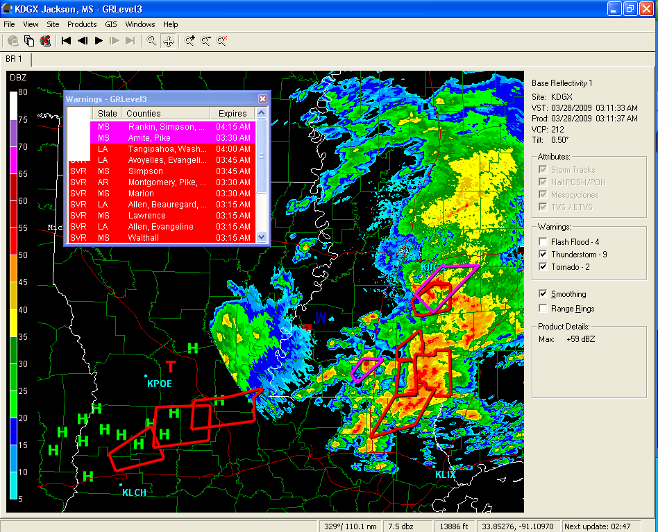
quote:There has been confirmation of a tornado touchdown in Magee, Mississippi, major damage and power outage reported.
quote:No fatalities were immediately reported, but authorities and rescue crews were still responding to the damaged areas north of Magee
quote:'Major damage' reported in possible Magee tornado - Possible twister also hits Madison County
Possible tornadoes struck Simpson and Madison counties early today, leaving extensive damage in their paths.
The Storm Prediction Center in Norman, Okla., which gathers and releases storm reports, said the Magee Police Department reported "major damage" on the north side of Magee after an early morning tornado.
The report from the Police Department also said injuries had been reported, although the extent and number were unknown.
A woman answering the phone at the Simpson County Sheriff's Department just after 2:30 a.m. said no one was available to speak at the time, as emergency officials still were assessing the situation and "just trying to see what we've got."
Phone lines at the Magee Police Department were busy.
Joanne Culin, a meteorologist with the National Weather Service in Jackson, said the agency never likes to say with certainty whether damage is the result of a tornado or straight-line winds until a full assessment can be made.
However, she said regarding the Magee storm that she felt "very confident that that was a tornado."
"The signature on radar was unmistakable," Culin said.
The storm containing the possible tornado rolled through the Simpson County city around 1:45 a.m., part of an intense line of storms ahead of an approaching cold front.
Magee is located about 40 miles south of Jackson on U.S. 49.
Just after midnight, another possible tornado moved out of northern Hinds County in central Mississippi and into southern Madison County, where there were reports of roofs blown off homes in the Annandale and Reunion subdivisions. Many trees and street signs also were reported down in Madison County.
Culin said the weather service received reports that two homes in the Ashbrooke subdivision, located off Rice Road north of the Natchez Trace in Madison, were damaged as was another house near Gluckstadt.
Other damage reported early this morning as the storms marched across Mississippi from west to east included:
Three homes damaged in Madison County's Cherry Hill subdivision.
Numerous trees down and power outages along Mississippi 24 West near Woodville in Wilkinson County.
Trees and power lines down along Mississippi 28 in Copiah County.
Trees down in Utica and Clinton in Hinds County, McNair in Jefferson County, West Lincoln in Lincoln County and Monticello in Lawrence County.
A carport blown away near Raleigh in Smith County.
On Wednesday, the Mississippi Emergency Management Agency reported storm damage in Lauderdale County in east Mississippi.
In that storm, two homes sustained major damage, while nine homes, one business and two barns sustained minor damage. Another business was reported to be a total loss.
MEMA and the National Weather Service urged Mississippians to stay aware of the continuing potential for severe weather through the early morning hours on Saturday.
The weather service said heavy rain, damaging wind and tornadoes will remain possible as a powerful spring storm system continues moving south toward Mississippi. Large hail is also possible, the weather service said.
"Now is the time for every family to make sure their emergency supply kit is well stocked," said Mike Womack, MEMA director. "It is also a perfect time to make sure you have a NOAA weather radio with fresh batteries."

Tevens severe weather verwacht deze nacht en morgen in het gebied Texas/Oklahoma/Kansas. Met name ontzettend veel sneeuw/blizzards. Verwachting rond 10/15cm.

Er is iig genoeg 'winterse'neerslag gevallen:quote:Op vrijdag 27 maart 2009 01:14 schreef Drasss het volgende:
Tevens severe weather verwacht deze nacht en morgen in het gebied Texas/Oklahoma/Kansas. Met name ontzettend veel sneeuw/blizzards. Verwachting rond 10/15cm.
Veel grote hagel (tot 3 inch / 7,6 cm). Verder een tornado melding en op het moment ook twee tornado-warnings plus een aantal severe weather warnings.
Sneeuw viel hier erg tegen. Niet eens een inch. Wel in het westen van de staat Oklahoma plekken die 10 inches of meer op hun donder hebben gekregen.
Helaas is het over 1 a 2 dagen weg omdat het volgende week weer 70F wordt.
Helaas is het over 1 a 2 dagen weg omdat het volgende week weer 70F wordt.
Net ontstond er een prachtige onweersbui boven men schoolcampus ( Oklahoma City )
Hier 1 van de foto's. Alles wat je ziet was eigenlijk aan het draaien..
Hier 1 van de foto's. Alles wat je ziet was eigenlijk aan het draaien..

Morgen (2 april) moderate risks voor tornado's in zuidoost Amerika. Kans op grote tornado's die langdurig van aard zullen worden/zijn. Ik ben heel erg benieuwd, kon wel eens een flinke outbreak gaan worden.
Mooie foto Drasss
Mooie foto Drasss
's Avonds een man, overdags rustig an
Thx Burnie. Zuid-oost ik denk dat Oklahoma net buiten de prijzen gaat vallen, maargoed er komt wel veel regen aan dus wie weet! Hele dag hier al windkracht 6 wat eigenlijk vrij normaal is...
Morgen kans op tornado's ergens rond Texas. Ben benieuwd. Nog niet echt een grote outbreak geweest dit jaar (zal morgen ook niet gebeuren).
's Avonds een man, overdags rustig an
Klopt Burnie. Verwachting is dat Oklahoma donderdagavond kleine kans op onweer heeft. Het zal daarna verder trekken richting het oosten.
Maar! in het weekend verwacht men toch wel wat spektakel. Zaterdag en Zondag grote kans op fikse onweersbuien met tornado's. Even afwachten hoe het eruit ziet rond vrijdag, maar men is nu al kleine waarschuwingen aan het geven.
Maar! in het weekend verwacht men toch wel wat spektakel. Zaterdag en Zondag grote kans op fikse onweersbuien met tornado's. Even afwachten hoe het eruit ziet rond vrijdag, maar men is nu al kleine waarschuwingen aan het geven.
We blijven het in de gaten houden. Voor Norman OK is nu een moderate risk afgegeven, dus kan nog wat worden vanmiddag/vanavond aldaar. Ben benieuwd wat het weekend gaat brengen (hier in NL in ieder geval heerlijk lenteweer).
's Avonds een man, overdags rustig an

Nou in Oklahoma City is alles iig voorbij getrokken. Klein beetje regen gehad, maar niks bijzonders. Alle regen zit nu ten zuiden/oosten van mij vandaan. Ik denk dat Little Rock en omstreken er flink last van gaan krijgen!
Wachten het weekend maar af, dan moet er wat gaan gebeuren
Wachten het weekend maar af, dan moet er wat gaan gebeuren
Nu gaat het ook wel aardig los, mooie onweerslijn aan het ontwikkelen rond Arkansas.
Ik ga het weekend ook maar eens kijken dan
Ik ga het weekend ook maar eens kijken dan
's Avonds een man, overdags rustig an
Waren flinke bosbranden hier in Oklahoma, maar geen tornado's of onweer in de buurt... Wel in andere staten oost van mij.
Zondag op maandag grote kans op tornado's in Texax/Oklahoma/Kansas dus we wachten rustig af...
Zondag op maandag grote kans op tornado's in Texax/Oklahoma/Kansas dus we wachten rustig af...

Maak je ook foto's ?quote:Op vrijdag 10 april 2009 15:59 schreef Drasss het volgende:
Waren flinke bosbranden hier in Oklahoma, maar geen tornado's of onweer in de buurt... Wel in andere staten oost van mij.
Zondag op maandag grote kans op tornado's in Texax/Oklahoma/Kansas dus we wachten rustig af...
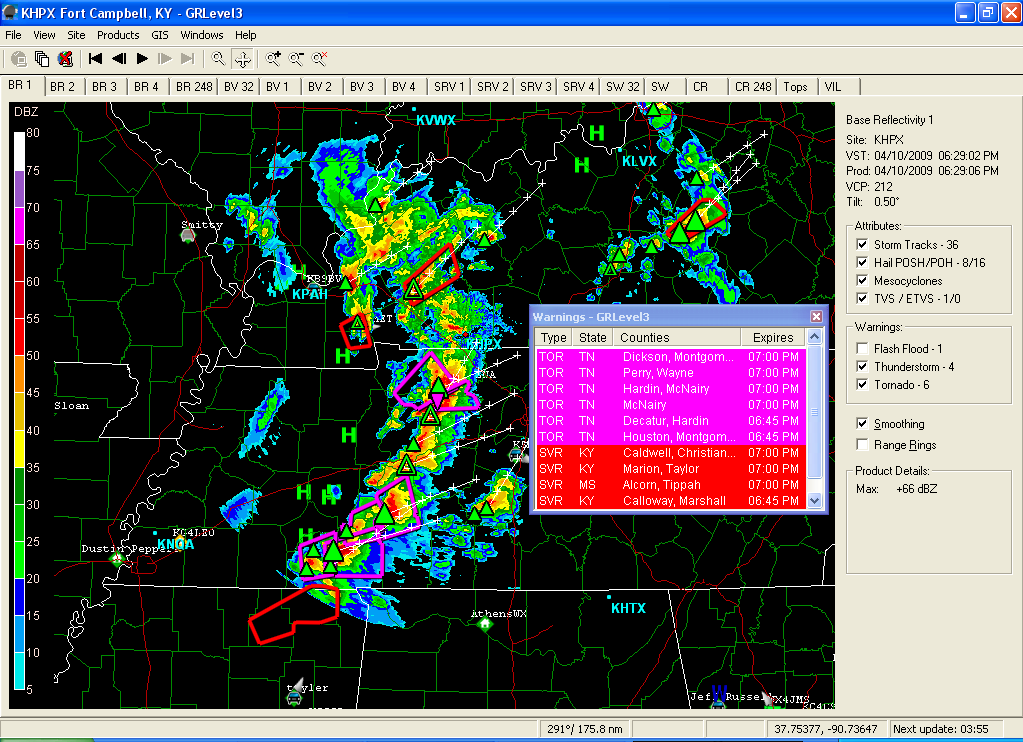
Momenteel flink heftig weer in USA, met hoge kans op flinke tornado's en hagel met doorsnee van 3" oftewel 7,5cm 
Drugs are good mkay?

Er zijn al enkele tornado's gemeld ja. En hagel (0,75" t/m 3") is daar ook geen probleem:quote:Op vrijdag 10 april 2009 21:23 schreef Party_P het volgende:
Momenteel flink heftig weer in USA, met hoge kans op flinke tornado's en hagel met doorsnee van 3" oftewel 7,5cm
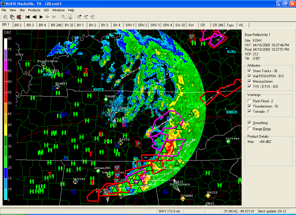
Verder staan er nog genoeg severe-weather/tornado - warnings open.