WKN Weer, Klimaat en Natuurrampen
Lees alles over het onstuimige weer op onze planeet, volg orkanen en tornado's, zie hoe vulkanen uitbarsten en hoe Moeder Aarde beeft bij een aardbeving. Alles over de verwoestende kracht van onze planeet en tal van andere natuurverschijnselen.


Handige linkjes:
� Onweerlinks 'live'
� Stormvue-sites
� Cape en voorspellende kaarten
� Wolkenkaarten en foto's
� Diverse weersites
� Achtergrond informatie
� Golven en wind
� Buienradar Nederland
� Buienradar West Europa
Overige informatie:
� Vorige delen 'De atmosfeer staat op ontploffen'
� Openingpost 'De atmosfeer staat op ontploffen'

Ach een beetje regen zou geen kwaad kunnen voor de tuin.... 
Als het maandag dan maar weer droog is... vind ik het niet zo erg
Als het maandag dan maar weer droog is... vind ik het niet zo erg
To deny our impulses would deny the very thing that make us human.

Voor maandag en dinsdag wordt ook nog regen voorspeld... 
Op zaterdag 15 augustus 2009 23:05 schreef eer-ik het volgende:
Ik vind je sig nogal denigrerend.
Ik vind je sig nogal denigrerend.
GFS heeft tot eind vd week nog neerslagkansen, EC is wat slechter... hopelijk komt het gewoon in de vorm van sneeuw

Vrijdag moet het weer droog zijn, de rest van de week mag het los gaan!
"We meet every day at the same cafe, six-thirty and no one knows she'll be there."
Na maandag toch beter weer in Nederland? Net dinsdag zit ik in Newcastle, veel zin in, maar 't voorspelde weer voor die dag is 13 graden en 'heavy rain'.  Terwijl volgens mij voor Nederland droog en 25 graden wordt voorspeld.
Wtf dinsdag staat er 24/28 en woensdag 22/27 wow  wel iets van 50 a 60% kans regen en zon 50 a 30%
  !
!
[b]Hobbelicious is back!
[/b]
[/b]
Ja ik zag hetquote:Op zaterdag 24 mei 2008 18:50 schreef MissHobje het volgende:
Wtf dinsdag staat er 24/28 en woensdag 22/27 wow
En die regen... dat zou wel onweer op het einde van de dag zijn..
To deny our impulses would deny the very thing that make us human.

Donderdag en vrijdag mooi weer graag. De rest van de week maakt het niet uit.
It's always around me, all this noise
But not nearly as loud as the voice saying
"Let it happen, let it happen (It's gonna feel so good)
Just let it happen, let it happen"
But not nearly as loud as the voice saying
"Let it happen, let it happen (It's gonna feel so good)
Just let it happen, let it happen"
hoe heete die bliksem site ook al weer ? iets van blitz.de
Sorry voor de evt. spelfouten maar ik heb een lichte vorm van dyslectie
blids.dequote:Op zaterdag 24 mei 2008 19:56 schreef daanski82 het volgende:
hoe heete die bliksem site ook al weer ? iets van blitz.de

Tis een heerlijke avond eigenlijk.. zie op de radar wel een mega vlak aankomen schuiven maar dis is vast opgelost voordat ie schiphol bereikt
[b]Hobbelicious is back!
[/b]
[/b]
Yesssssssquote:Op zaterdag 24 mei 2008 17:41 schreef ItaloDancer het volgende:
GFS heeft tot eind vd week nog neerslagkansen, EC is wat slechter... hopelijk komt het gewoon in de vorm van sneeuw
Ik kan het je wel uitleggen maar het niet voor je begrijpen........

Brrr het is meteen een stuk kouder... *rilt*
To deny our impulses would deny the very thing that make us human.
Valt reuze mee vind ik..quote:Op zondag 25 mei 2008 08:31 schreef appelsientje het volgende:
Brrr het is meteen een stuk kouder... *rilt*
Tis gewoon klef buiten.
Regent wel hard door trouwens.. dat is wel bah.
Ik wil onweer!
[b]Hobbelicious is back!
[/b]
[/b]
TT 704:
maandag 22, dinsdag 25, woensdag 27, donderdag 23, vrijdag 22.
En dan staat erbij als praatje:
Enkele (onweers)buien, vooral dinsdag en woensdag ook perioden met zon en warm. Vanaf donderdag koeler, minder buien en van tijd tot tijd zon.
Koeler?? 5 graden boven normaal; mei 2008 wordt de warmste mei ooit
Stel dat het omgekeerd was:
maandag 12, dinsdag 9, woensdag 7, donderdag 11, vrijdag 12 (overdag he)
En dat er dan staat: Vooral dinsdag en woensdag koud. Vanaf donderdag zachter. 
maandag 22, dinsdag 25, woensdag 27, donderdag 23, vrijdag 22.
En dan staat erbij als praatje:
Enkele (onweers)buien, vooral dinsdag en woensdag ook perioden met zon en warm. Vanaf donderdag koeler, minder buien en van tijd tot tijd zon.
Koeler?? 5 graden boven normaal; mei 2008 wordt de warmste mei ooit
Stel dat het omgekeerd was:
maandag 12, dinsdag 9, woensdag 7, donderdag 11, vrijdag 12 (overdag he)
En dat er dan staat: Vooral dinsdag en woensdag koud. Vanaf donderdag zachter.
Het KNMI heeft het wel over "aanhoudend warm", die weten nog wel wat voor weer het was in de vorige eeuw
28 is graden is niet zo erg maar met bewolimg is het wel minder prettig goed, onweer mag wel weer is
Never Stop Exploring!
Life begins at the end of your comfort zone!
Follow me on Twitter: https://twitter.com/EdwinKr83 Instagram: https://www.instagram.com/edwinkr83/
Life begins at the end of your comfort zone!
Follow me on Twitter: https://twitter.com/EdwinKr83 Instagram: https://www.instagram.com/edwinkr83/


7 uur zon, 0 mm regen, 20 graden.... Ja, gaat goed met die voorspelling... 
Op zaterdag 15 augustus 2009 23:05 schreef eer-ik het volgende:
Ik vind je sig nogal denigrerend.
Ik vind je sig nogal denigrerend.
0 uur zon, 2 mm regen, 14 graden... Ja, gaat goed met die voorspelling...quote:Op zondag 25 mei 2008 16:39 schreef OA het volgende:
7 uur zon, 0 mm regen, 20 graden.... Ja, gaat goed met die voorspelling...

Zeg, volgens mij ben jij al een X aantal keer "vergeten" mee te doenquote:Op zondag 25 mei 2008 17:23 schreef i2Them2 het volgende:
[..]
0 uur zon, 2 mm regen, 14 graden... Ja, gaat goed met die voorspelling...

Kwartetterquote:Op zondag 25 mei 2008 17:38 schreef ItaloDancer het volgende:
Als je het raam open hebt staan tenminste, wat ik dus heb.
Tevens quattro.
Ik heb meteen de screens en het zonnescherm naar beneden gedaan!
Op zaterdag 15 augustus 2009 23:05 schreef eer-ik het volgende:
Ik vind je sig nogal denigrerend.
Ik vind je sig nogal denigrerend.
Nietesquote:Op zondag 25 mei 2008 18:07 schreef IkWilbert het volgende:
Hier wat gemiezer in het oosten des landes.
O, laat dit waar zijn. Mijn regioquote:Op zondag 25 mei 2008 19:58 schreef aloa het volgende:
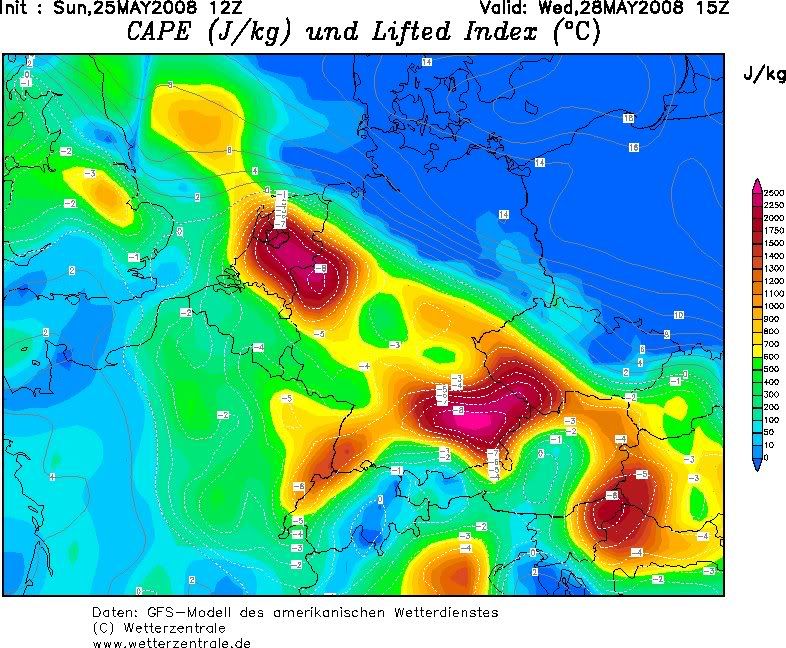
Het ziet er wel heftig uit voor woensdag.
wetterzentrale
[ afbeelding ]
Als de kaarten kloppen kan het hele land te maken krijgen met zware buien. Van dinsdagmiddag t/m woensdag avond.
Uitgezonderd het zuidwesten!quote:Op zondag 25 mei 2008 19:58 schreef aloa het volgende:
Het ziet er wel heftig uit voor woensdag.
wetterzentrale
[ afbeelding ]
Thanks.
Life is Music
quote:Op zondag 25 mei 2008 22:09 schreef aloa het volgende:
[..]
bekijk deze dan even:
woensdag 09.00
woensdag 12.00
Wel een raar tijdstip voor onweer.
Life is Music
Bij http://www.lightningwizard.com/maps/ is toch ook te zien dat niet alleen de cape er goed uit ziet. Al is het nog een tijdje weg, en kan het nog best wel een aantal kanten op.quote:
estofex voor dinsdag en woensdag (voor wat het waard is op dit moment)
quote:Extended Forecast
Valid: Tue 27 May 2008 06:00 to Wed 28 May 2008 06:00 UTC
Issued: Sun 25 May 2008 20:25
Forecaster: GROENEMEIJER
SYNOPSIS
East of the large-scale trough over the Bay of Biscay and Iberia a shortwave trough moves northward from the western Mediterranean Sea to central France. This shortwave is embedded in a strong southerly jet with speeds of 30-35 m/s at 500 hPa. A surface low is projected to move from near the Balearic Islands to Brittany.
DISCUSSION
Level 1 and 2 areas...
Widespread convective precipitation is expected over NE Spain and SE France in an area of upward vertical motion ahead of the aforementioned low pressure centre. Those embedded storms will probably be elevated, but steep lapse rates and strong low-level winds could still produce isolated severe hail and strong to severe gusts.
A warm front is expected to stretch from the Pyrenees to the Benelux countries. On its warm side dry air is advected northwestward out of the Alpine region into France. The evolution of the preciptation and cloudiness across southern France is hard to forecast, but per GFS this should shift northwestward to western France in concert with the frontal zone. This may leave an area in its wake where the sun has opportunity to heat the boundary layer. This could potentially create some surface-based instability in a region with large low level hodographs (300 m2/s2 SRH) and create a threat of strong tornadoes. In case low-level instability remains too limited for surface-based tornadic storms, they will still be likely to produce rather widespread severe gusts, given the already strong 25 m/s wind speeds at 850 hPa. Possibly, enough forcing will be available for a well-defined squall-line to move northward more or less across the area indicated as level 2.
An open question is to what extent storms will form further north along the warm front across NW france and the Benelux countries. It is not unthinkable that, during the late afternoon and evening, some storms develop there also. Given the high storm-relative helicity that is forecast, these may develop into supercells with a threat of hail, damaging gusts and tornadoes as well. Currently, our best estimate is that surface-based storms will mostly be restricted to central and W-central France until early evening, but that NW France the Benelux and possibly SE England will be affected by organized storms overnight.
Low storm coverage is forecast across NE France, Germany, Switzerland and NW Italy. But, as more than 1000 J/kg CAPE, steep mid-level lapse rates and moderate deep-layer shear are expected, storms could easily produce large hail and strong downdrafts, so that a level 1 appears to be warranted for this area also.
* I intend to live forever, so far so good! *
't is niet warm. Ik las in De Pers vanochtend: gemiddeld 17 graden vandaag als max (WeerOnline). Dat lijkt een betere voorspelling dan het KNMI en anderen met 17-19 graden in het noorden tot 24 in het zuiden. Al weet je niet wat er gebeurt als de zon er nog eens eventjes doorkomt... maar voorlopig geen sprake van
de eerder geplaatste cape hier van gister voor a.s woensdag is al lang niet meer zo heftig...
We staan de bakken met neerslag die eerder voor de woensdag gepland stonden weer trug op de kaarten en nu komen ze op donderdagavond. Eind van de middag tot ergens middernacht.
We staan de bakken met neerslag die eerder voor de woensdag gepland stonden weer trug op de kaarten en nu komen ze op donderdagavond. Eind van de middag tot ergens middernacht.

Never Stop Exploring!
Life begins at the end of your comfort zone!
Follow me on Twitter: https://twitter.com/EdwinKr83 Instagram: https://www.instagram.com/edwinkr83/
Life begins at the end of your comfort zone!
Follow me on Twitter: https://twitter.com/EdwinKr83 Instagram: https://www.instagram.com/edwinkr83/
quote:Op maandag 26 mei 2008 15:24 schreef IkWilbert het volgende:
estofex.org heeft een update voor vandaag.
[ afbeelding ]
quote:DISCUSSION
Belgium, Netherlands, NW Germany, N-central France
The extent of cloudiness associated with a partly stratifrom/partly convective rain zone associated with a diffuse cold front extending in N/S direction across France has been much less than anticpated. Widespread clearings have formed to the north of this area across Belgium, N France and NE France south of a west-east oriented warm front across Belgium.
Visible satellite imagery shows towering cumulus developing across Belgium and the French région Nord. There and later elsewhere, isolated storms are expected to form. Up to 1000 J/kg of CAPE would be available to those storms, that develop in an environment of rather strong deep-layer wind shear of 20-30 m/s and high storm-relative helicity. As a result, they may develop into supercells capable of producing some large hail, and strong winds. Tornadoes are not ruled out either. A preferred location may be the warm front across Belgium that extends into the German Rhineland.