WKN Weer, Klimaat en Natuurrampen
Lees alles over het onstuimige weer op onze planeet, volg orkanen en tornado's, zie hoe vulkanen uitbarsten en hoe Moeder Aarde beeft bij een aardbeving. Alles over de verwoestende kracht van onze planeet en tal van andere natuurverschijnselen.


@CRASH
heb je bericht ff in het topic van de Redoubt gegooid! Thx!
BREAKING: Uitbarsting Mt.Redoubt (Alaska)
heb je bericht ff in het topic van de Redoubt gegooid! Thx!
BREAKING: Uitbarsting Mt.Redoubt (Alaska)

Er staat een update met foto op de bovenstaande link:
quote:Brian Whittaker
Image taken:
Mar. 25, 2009
Location:
Airborne at 39,000 feet over Mt Robson, highest point in the Canadian Rocky Mountains (NE British Columbia)
Details:
As I flew past this brownish cloud of what looked to me like volcanic ash, I remembered that Alaska's Mt Redoubt was upstream from my location. Thanks to the SpaceWeather.com published SO2 animation, I was able to confirm my sighting. Volcanic ash has a certain look which can be rather rusty from certain angles with the sun low in the sky.

be nice or go away

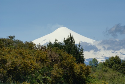
http://www.laht.com/article.asp?ArticleId=331248&CategoryId=14094quote:[b]Locals Evacuated After Eruption of Chile’s Llaima Volcano
SANTIAGO – The reactivation of the Llaima volcano some 600 kilometers (323 miles) south of Santiago sparked the declaration of a red alert and orders to evacuate local residents, the regional press said.
The volcano, dormant for half a year, erupted again Friday night with explosions and the spewing forth of incandescent material that reached some 600 meters (1,967 feet) above the crater, which is 3,210 meters (10,524 feet) high.
Authorities ordered the closure of Conguillio National Park where the Llaima volcano is located and evacuated the 14 people who were inside it, including five construction workers, seven park guards and two tourists, one a Spaniard and the other Chilean.
The daily El Mercurio also said that three people have been evacuated from the ski resort of Las Araucarias.
The regional government of La Araucania also declared a red alert in eight nearby towns, from which it hopes to evacuate 70 people away from the expected shower of ash and debris.
Regional emergency services that met Saturday in Temuco and were scheduled to meet later in Cherquenco also decided to do a census of domestic animals in the area and analyze the kind of ash pouring from the volcano.
Llaima, considered one of the most active volcanos in South America, is located some 76 kilometers (47 miles) northeast of Temuco, capital of the La Araucania region, and at its feet are the towns of Curacautin, Cherquenco and Melipeuco.[/b]
http://thestar.com.my/news/story.asp?file=/2009/4/5/apworld/20090405093719&sec=apworldquote:Llaima volcano spews lava, ash in southern Chile
SANTIAGO, Chile (AP) - One of Chile's most active volcanos is spewing lava and ash again, prompting evacuations and landslide warnings.
The national emergency department is reporting that the 10,250-foot-high (3,125-meter-high) Llaima volcano has hurled explosive materials up to 600 meters (650 yards) above the crater and issued a flow of lava more than 1,000 yards (meters) long.
A statement from the department Saturday noted that villagers were evacuated as a precaution after officials conducting flyovers saw snow melting around the crater, "which means a high risk of mudslides ... (and) the possible rising of the Calbuco River."
The volcano is located 380 miles (600 kilometers) south of the capital, Santiago.
Its last big eruption was in January 2008. -AP
Hier ook een filmpje.

Op zaterdag 15 augustus 2009 23:05 schreef eer-ik het volgende:
Ik vind je sig nogal denigrerend.
Ik vind je sig nogal denigrerend.

Pff schrok even maar gelukkig bezoekt m'n vriend nu de Vulkaan in Pucon en ligt die redelijk ver van Vulkaan Llaima.:o 
People demand freedom of speech as a compensation
for the freedom of thought which they seldom use.
for the freedom of thought which they seldom use.
mee lees post
DeLuna vindt me dik ;(
Op zondag 22 juni 2014 12:30 schreef 3rdRock het volgende:
pas als jullie gaan trouwen. nu ben je gewoon die Oom Rubber die met onze mama leuke dingen doet :)
Op zondag 22 juni 2014 12:30 schreef 3rdRock het volgende:
pas als jullie gaan trouwen. nu ben je gewoon die Oom Rubber die met onze mama leuke dingen doet :)
Dat is inderdaad geluk!quote:Op zondag 5 april 2009 13:00 schreef Ad_rem het volgende:
Pff schrok even maar gelukkig bezoekt m'n vriend nu de Vulkaan in Pucon en ligt die redelijk ver van Vulkaan Llaima.:o
Dubbel denk ik, want de Villarrica is echt een mooie vulkaan. Perfecte vorm, mooie omgeving, bijna altijd met rookpluim, etc!
Op zaterdag 15 augustus 2009 23:05 schreef eer-ik het volgende:
Ik vind je sig nogal denigrerend.
Ik vind je sig nogal denigrerend.

De unieke fuana op de Galapagos eilanden is in gevaar. Vulkaan La Cumbre is uitgebarsten en talloze dieren worden bedreigd door de lavastroom die naar zee stroomt.quote:"La Cumbre" bedroht Tierwelt auf Galápagos-Inseln
Die einzigartige Fauna auf den Galápagos-Inseln ist in Gefahr: Der Vulkan "La Cumbre" ist ausgebrochen, zahlreiche Tiere sind durch die ins Meer fließende Lava bedroht. Menschen sind bislang nicht zu Schaden gekommen.
http://www.spiegel.de/wissenschaft/natur/0,1518,618703,00.htmlquote:Quito - Ein Vulkanausbruch auf den Galápagos-Inseln im Ostpazifik bedroht die einzigartige Tierwelt. Der Vulkan La Cumbre auf der Insel Fernandina speie seit Samstag Lava, Gas und Rauch, teilte die Nationalparkbehörde mit. Anwohner auf der Nachbarinsel Isabela seien nicht betroffen, die ins Meer fließende Lava könne aber Leguane, Wölfe und weitere Tiere schädigen. La Cumbre brach zuletzt im Mai 2006 aus.
Das zu Ecuador gehörende Galápagos-Archipel ist für seine einmalige Tier- und Pflanzenwelt bekannt. Einige Arten wie zum Beispiel die Galápagos-Riesenschildkröte kommen nur auf den mehr als 114 Inseln vor.
Auch in Alaska hat ein Vulkanausbruch Anfang April die Natur gefährdet. Ein Strom von Schmelzwasser und heißen Felsbrocken wälzte sich durch das Tal des Drift River und erreichte das gleichnamige Ölterminal des Chevron-Konzerns.
Ausbruch vereitelte den Plan, die dort gelagerten 23,9 Millionen Liter Öl vorsorglich in Sicherheit zu bringen. Ein Tanker musste unverrichteter Dinge wieder zurückkehren.
Op zaterdag 15 augustus 2009 23:05 schreef eer-ik het volgende:
Ik vind je sig nogal denigrerend.
Ik vind je sig nogal denigrerend.

quote:La Cumbre Volcano on Isla Fernandina remained active on April 12, 2009, as the Moderate Resolution Imaging Spectroradiometer (MODIS) on NASA’s Aqua passed overhead. According to the U.S. Air Force Weather Agency, the volcano experienced continuous ash and steam emissions.
Compared to the image acquired the previous day, this image shows a much smaller red-outlined hotspot of anomalously warm surface temperatures. The plume has spread over a wider area, and now travels primarily toward the southwest. A segment of the plume appears north of Isla Fernandina, suggesting a shift in wind direction at some point. Compared to the clouds over Isla Isabela and Isla Fernandina, the volcanic plume is slightly darker and thinner, with less distinct margins.
CHILE’S CHAITÉN VOLCANO CONTINUES TO RUMBLE
http://www.patagoniatimes(...)INUES-TO-RUMBLE.html
quote:Chaitén erupted last May for first time in recorded history
Southern Chile’s Chaitén volcano has produced a “continual and sustained increase” in seismic activity in recent days, raising concerns of yet another possible eruption, the National Geologic and Mining Service (SERNAGEOMIN) reported Wednesday.
Since April 7 monitors have recorded an average of 16 small quakes per day, some of them as strong as 4.5 degrees on the Richter scale. Previously the volcano produced an average of 10 daily tremors.
“This could provoke eventual explosions and ash flows that cold affect the adjacent valleys,” said SERNAGEOMIN.
Chaitén erupted last May for the first time in recorded history, sending up a massive plume of ash that at one point reached as far as Buenos Aires, Argentina (PT, May 2, 2008). The Region X volcano, located some 1,200 kilometers south of Santiago, buried the nearby town of Chaitén and forced the evacuation of its approximately 8,000 residents.
Government authorities decided earlier this year not to rebuild Chaitén – which was also badly damaged by floods – on its original location. A decision was made instead to relocate the town to nearby Santa Barbara, where construction on the “new Chaitén” is currently underway.
Chile has one of the most active volcanic chains in the world. Just last week another Chilean volcano, Region IX’s Llaima, erupted, releasing a 7,000-meter-high column of smoke and ash and producing several dramatic lava flows (PT, April 6).
Llaima, one of the country’s most active volcanoes, has erupted several times since mid 2007. In 2008 it brought in the New Year with a spectacular eruption, coughing up huge plumes of glowing lava. Exactly six months later Llaima awoke yet again.

http://www.patagoniatimes(...)INUES-TO-RUMBLE.html
Op zaterdag 15 augustus 2009 23:05 schreef eer-ik het volgende:
Ik vind je sig nogal denigrerend.
Ik vind je sig nogal denigrerend.
http://itn.co.uk/news/9d63253fd90903df570149b89bbde3bf.htmlquote:A volcano in the Galapagos Islands has rumbled into life again a week after it erupted.
The Geophysical Institute of the National Polytechnic School reported 43 thermal alerts and said that satellite images revealed a column of gas that extended more than 60 miles (100 kilometres) west of the islands, indicating an increase in volcanic activity.
The La Cumbre volcano began spewing lava, gas and smoke on Fernandina Island on Saturday after four years of inactivity.
Experts are concerned the activity may be taking a toll on the islands' famed wildlife and will launch a study on the environmental impact of the volcano in the coming days.
Charles Darwin developed his theory of evolution after studying the unique animal populations of the Galapagos Islands - and they have attracted biologists and conservationists ever since.
The islands are scarcely populated, but the United Nations last year said the pristine environment of the Pacific island chain was in danger due to booming tourism.
Op zaterdag 15 augustus 2009 23:05 schreef eer-ik het volgende:
Ik vind je sig nogal denigrerend.
Ik vind je sig nogal denigrerend.
images of Kilauea Volcanoquote:Wednesday, May 13, 2009 7:43 AM HST (Wednesday, May 13, 2009 17:43 UTC)
This report on the status of Kilauea volcanic activity, in addition to maps, photos, and webcam images (available using the menu bar above), was prepared by the USGS Hawaiian Volcano Observatory (HVO). Hawai`i Volcanoes National Park status can be found at http://www.nps.gov/havo/ or 985-6000. Hawai`i County Viewing Area status can be found at 961-8093.
KILAUEA VOLCANO (CAVW #1302-01-)
19°25'16" N 155°17'13" W, Summit Elevation 4091 ft (1247 m)
Current Aviation Color Code: ORANGE
Current Volcano Alert Level: WATCH
Activity Summary for past 24 hours: Glow from the Halema`uma`u vent continues to be visible. Lava from east rift zone vents continues to flow through tubes to the coast and is entering the ocean at two locations west of Kalapana. Sulfur dioxide emission rates from the Halema`uma`u and Pu`u `O`o vents remain elevated.
Past 24 hours at Kilauea summit: A molten lava pool remains near the base of the cavity deep below the floor of Halema`uma`u Crater and is producing a visible, but decreasing in intensity, glow (recorded by both webcams pointed at it - see our new "Webcams" link at hvo.wr.usgs.gov); the decreasing glow suggests that the surface of the lava pool may be receding.
This morning, the gas plume rises about 600 m (2,000 ft) above the Halema`uma`u Crater rim and moves to the west; GOES-WEST imagery shows the plume continuing to the WNW into the east flank of Mauna Loa where it is diverted southward. Sulfur dioxide emission rates remain elevated and variable; the most recent rate measurement was 1,200 tonnes/day on May 12, compared to the 2003-2007 average rate of 140 tonnes/day. Small amounts of mostly ash-sized tephra continue to be produced consisting mostly of Pele's hair, irregular pieces of vesicular glass, and a few hollow spherules. Gas-rushing and rockfall sounds were again heard during the morning collection routine.
Tremor levels remain at moderate values. Two earthquake were located beneath the south summit, five on south flank faults, and only one earthquake was located in the area about 4 km (3 mi) northwest of Halema`uma`u Crater. The number of RB2S2BL earthquakes were within background levels.
The network of tiltmeters at Kilauea's summit recorded no significant tilting. The GPS network (less sensitive than the tiltmeter network) has recorded about 1 cm of contraction across the caldera over the past 3 months.
Past 24 hours at the middle east rift zone vents and flow field: Magma continues to degas through Pu`u `O`o Crater before erupting from vents to the east. The most recent measurement was 1,400 tonnes/day measured on May 8, compared to the 2003-2007 average of about 1,700 tonnes/day. No incandescence was recorded within the crater overnight.
The tiltmeter on the north flank of Pu`u `O`o stopped reporting to HVO just before 8 am Saturday; technicians will resolve the problem later this week when helicopter time becomes available. GPS receivers on opposite sides of the crater have documented about 1.5 cm of contraction over the past month and more than 5 cm over the past 3 months. Seismic tremor levels near the eruptive vents are low and steady.
Lava from the TEB vent and the rootless shield complex flows through tubes to the ocean at Waikupanaha and Kupapa`u. MODIS imagery showed ocean entry plumes moving southwest along the coast yesterday afternoon from lava continuing to enter the ocean. Weak thermal anomalies were present on the coastal plain through this morning in GOES-WEST imagery; anomalies of this intensity are usually not associated with active surface flows but rather inactive, cooling flows.
HAZARD ALERT: The lava delta and adjacent areas both inland and out to sea are some of the most hazardous areas on the flow field. Frequent delta/bench collapses give little warning, can produce hot rock falls inland and in the adjacent ocean, and can produce large but local waves. The steam plume produced by lava entering the ocean contains fine lava fragments and an assortment of acid droplets that can be harmful to your health. The rapidly changing conditions near the ocean entry have been responsible for many injuries and a few deaths.
Maps, photos, webcam views, and other information about Kilauea Volcano are available at
http://volcano.wr.usgs.gov/kilaueastatus.php

Pauze in vulkanisme veranderde de aarde in een sneeuwbal
Een lange onderbreking in vulkanisme heeft er 2,45 miljard jaar geleden toe geleid dat de aarde veranderde in één grote sneeuwbal. De 200 miljoen jaar durende periode zonder vulkaanuitbarstingen was mogelijk het gevolg van een onderbreking in de plaattektoniek, het geschuif van stenige continenten over een stroperige aardmantel dat het aanzien van de aarde bepaalt.
Mount St. Helens.
Foto USGS De vulkaanpauze viel samen met het ontstaan van een zuurstofrijke atmosfeer. Dat concluderen Amerikaanse en Australische aardwetenschappers uit een inventarisatie van de ouderdom van stukken aardkorst en vulkanische afzettingen, verspreid over de hele wereld (Earth and Planetary Science Letters, 21 april 2009).
De studie onder leiding van Kent Condie (New Mexico Tech) laat zien dat er tussen 2,45 miljard jaar en 2,2 miljard jaar geleden nauwelijks gesteente ontstond uit vulkanen of door de hoge druk en temperatuur die ontstaat als twee aardplaten op elkaar botsen. Mogelijk was het binnenste van de aarde zo warm en vloeibaar dat er soms onvoldoende grip was om schollen over het aardoppervlak voort te stuwen.
Volgens Condie resulteerde een drastische verlaging in de uitstoot van gassen uit vulkanische erupties ook in een sterke afname van het CO2-gehalte in de atmosfeer. De aarde koelde sterk af en raakte met sneeuw en ijs bedekt. Zonder vulkanische uitbarstingen was er ook minder ijzeruitstoot, waardoor zuurstof niet werd vastgelegd in ijzeroxiden, maar vrijkwam in de atmosfeer. Het gebrek aan ijzer zou ook een wereldwijd hiaat verklaren in de vorming van banded iron formations, afwisselende lagen van ijzerrijk en ijzerarm gesteente.
Condie baseert de datering van stenen op het mineraal zirkoon. De mate waarin het daarin aanwezige uranium tot lood is vervallen, is een maat voor de ouderdom ervan.
nrc
Vulkaan Galeras komt tot uitbarsting in Colombia
In Colombia is de vulkaan Galeras vandaag om 7.18 uur (14.18 uur Belgische tijd) tot uitbarsting gekomen. Dat meldt het Colombiaanse geologische instituut Ingeominas. De vulkaan ligt in het departement Narino in het zuiden van het land, aan de grens met Ecuador.
Vijfde uitbarstiing
Wegens gebeurtenissen "met explosief karakter" ging het alarmpeil op rood staan. Dat betekent een uitbarsting "die zeer nabij is of al bezig is", verduidelijkt Ingeominas. Het gaat om de vijfde uitbarsting van de Galeras in minder dan anderhalf jaar. De laatste uitbarsting dateert van eind april. Die bleef zonder gevolg voor de zowat 7.000 inwoners uit de omgeving. In 1993 kwamen negen personen om bij een uitbarsting van de Galeras. De vulkaan ligt in het Andesgebergte en reikt tot 4.270 meter hoogte.
Geen slachtoffers
Bij de uitbarsting van vandaag zijn er geen slachtoffers gevallen. Ook is er geen schade aangericht. Er is alleen vulkanische as neergevallen in de gemeente Sandona. (belga/ep)

Hires foto
Sarychev Peak Volcano eruption, Kuril Islands
quote:International Space Station Imagery
ISS020-E-009048 (12 June 2009) --- Sarychev Peak Volcano eruption, Kuril Islands, is featured in this image photographed by an Expedition 20 crew member on the International Space Station. A fortuitous orbit of the International Space Station allowed the astronauts this striking view of Sarychev volcano (Russia's Kuril Islands, northeast of Japan) in an early stage of eruption on June 12, 2009. Sarychev Peak is one of the most active volcanoes in the Kuril Island chain and is located on the northwestern end of Matua Island. Prior to June 12, the last explosive eruption had occurred in 1989 with eruptions in 1986, 1976, 1954, and 1946 also producing lava flows. Ash from the June 2009 eruption has been detected 2407 kilometers ESE and 926 kilometers WNW of the volcano, and commercial airline flights are being diverted away from the region to minimize the danger of engine failures from ash intake. This detailed photograph is exciting to volcanologists because it captures several phenomena that occur during the earliest stages of an explosive volcanic eruption. The main column is one of a series of plumes that rose above Matua Island (48.1 degrees north latitude and 153.2 degrees east longitude) on June 12. The plume appears to be a combination of brown ash and white steam. The vigorously rising plume gives the steam a bubble-like appearance; the surrounding atmosphere has been shoved up by the shock wave of the eruption. The smooth white cloud on top may be water condensation that resulted from rapid rising and cooling of the air mass above the ash column, and is probably a transient feature (the eruption plume is starting to punch through). The structure also indicates that little to no shearing winds were present at the time to disrupt the plume. Another series of images, acquired 2-3 days after the start of eruptive activity, illustrate the effect of shearing winds on extent of the ash plumes across the Pacific Ocean. By contrast, a cloud of denser, gray ash -- most probably a pyroclastic flow -- appears to be hugging the ground, descending from the volcano summit. The rising eruption plume casts a shadow to the northwest of the island (bottom center). Brown ash at a lower altitude of the atmosphere spreads out above the ground at upper right. Low-level stratus clouds approach Matua Island from the east, wrapping around the lower slopes of the volcano. Only about 1.5 kilometers of the coastline of Matua Island (upper center) can be seen beneath the clouds and ash.
<a href="http://www.vwkweb.nl/" rel="nofollow" target="_blank">Vereniging voor weerkunde en klimatologie</a>
<a href="http://www.estofex.org/" rel="nofollow" target="_blank">ESTOFEX</a>
<a href="http://www.estofex.org/" rel="nofollow" target="_blank">ESTOFEX</a>
Vulcanic Sunsets
Sky watchers in Europe should be alert for volcanic sunsets.
A mass of sulfur dioxide from Russia's Sarychev Peak volcano is swirling through the stratosphere over the North Atlantic and it appears poised to move over land during the next 24 hours.
movie by the GOME-2 sensor onboard Europe's
MetOp-A satellite shows the progress of the plume
Sky watchers in Europe should be alert for volcanic sunsets.
A mass of sulfur dioxide from Russia's Sarychev Peak volcano is swirling through the stratosphere over the North Atlantic and it appears poised to move over land during the next 24 hours.
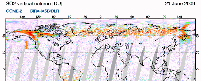
movie by the GOME-2 sensor onboard Europe's
MetOp-A satellite shows the progress of the plume
<a href="http://www.vwkweb.nl/" rel="nofollow" target="_blank">Vereniging voor weerkunde en klimatologie</a>
<a href="http://www.estofex.org/" rel="nofollow" target="_blank">ESTOFEX</a>
<a href="http://www.estofex.org/" rel="nofollow" target="_blank">ESTOFEX</a>


On June 12, 2009, Sarychev Peak on the Kuril Islands’ Ostrov Matua experienced a spectacular eruption. The event left behind a changed island. Acquired by the Advanced Spaceborne Thermal Emission and Reflection Radiometer (ASTER) on NASA’s Terra satellite, these images of Ostrov Matua show the island shortly after the eruption on June 30, 2009 (top), and two years before on May 26, 2007 (bottom).
In these false-color images, vegetation appears red, water appears dark blue, and clouds, water vapor and ice all appear white. Volcanic rock, including old lava flows and debris from the recent eruption, ranges from gray to dark brown.
The most striking difference between these two images is the gray coating on the northwestern half of the island in June 2009. While vegetation on the rest of the island appears lush, volcanic debris—probably a mixture of pyroclastic flows and settled ash—covered virtually all the vegetation on the northwestern end. A close look at the top image also reveals that the recent volcanic activity appears to have expanded the island’s coastline on the northwestern end.
Another difference between the images relates to snow cover. In the image from May 2007, snow spreads over much of the island, although the snow alternates with snow-free ground. The vegetation is pinkish-gray, suggesting the spring thaw is still underway. The complete lack of snow in 2009 may result from a combination of a difference in season and volcanic activity having melted or covered any lingering snow.
Dankzij die quake dus?quote:Authorities raise Mt. Talang alert level to highest
The vulcanology and disaster mitigation office in West Sumatra has raised the alert status for Mt. Talang to the highest level following a 6.9-magnitude earthquake and a series of aftershocks that struck the province.
Vulcanologist Dalipa Marjusi said Tuesday the tremors had sparked a volcanic earthquake and temblors, although eruption of the volcano remained undetected.
“Since Sunday’s earthquake we have recorded 1,600 volcanic quakes and 700 tectonic quakes, but only 23 of them were felt,” Dalipa said.
Fog has blanketed the summit of the 2,597-meter volcano for the last two days, making it difficult to see ash or lava that might be erupting from its crater.
The volcano last spewed hot ash last April.
A seven-strong team from the directorate general of vulcanology and disaster mitigation have arrived in Padang from Bandung to monitor the volcano’s activities.
Zal morgenochtend eens een kaartje pakken om te zien hoe groot de afstand is.. het is al negen uur hier en ik heb al een dag barstende koppijn, dus ik ga lekker slapen (alweer)..quote:
Ik ben benieuwd wat er gaat gebeurenquote:
Ik ben illegaal!
Op woensdag 1 december 2010 16:07 schreef honkeytonk het volgende:Ik denk zelfs dat ze achter de schermen een fantopic over mij hebben geopend :Y
Op woensdag 1 december 2010 16:07 schreef honkeytonk het volgende:Ik denk zelfs dat ze achter de schermen een fantopic over mij hebben geopend :Y