WKN Weer, Klimaat en Natuurrampen
Lees alles over het onstuimige weer op onze planeet, volg orkanen en tornado's, zie hoe vulkanen uitbarsten en hoe Moeder Aarde beeft bij een aardbeving. Alles over de verwoestende kracht van onze planeet en tal van andere natuurverschijnselen.


quote:Op woensdag 22 augustus 2007 17:14 schreef SpeedyGJ het volgende:
Orkaan overleeft noordzee en ramt Nederland met Cat 3 Zucht
Life is Music
Kwam dat maar uitquote:
<a href="https://www.youtube.com/channel/UCPueUwKfPaGH7v48LZlltkg" rel="nofollow" target="_blank">WSDokkum Youtube</a>
Dean is weer cat 2
Luchtdruk 979 hPa en winden 85 knopen (ong. 155 km/u).
Luchtdruk 979 hPa en winden 85 knopen (ong. 155 km/u).
<a href="https://www.youtube.com/channel/UCPueUwKfPaGH7v48LZlltkg" rel="nofollow" target="_blank">WSDokkum Youtube</a>
BreakingNewsOn: BREAKING NEWS -- Center of category 2 hurricane Dean makes landfall in Mexico near the town of Tecolutla, according to the NHC.

final landfall
Dostojewski: "Je kunt je niet van je eigen gezond verstand overtuigen door je buurman op te sluiten."

Dean made its second landfall about 40 miles south-southeast of Tuxpan, Mexico at 11:30am (Central Time) along the coast of the Mexican state of Veracruz between the cities of Tampico and Veracruz. Maximum sustained winds at landfall were near 100 mph with a minimum central pressure of about 979 millibars.
As of 1 PM CDT Dean is now down to a category 1 with (85 mph) winds moving inland with a threat for flooding rain in the interior of Mexico.
As of 1 PM CDT Dean is now down to a category 1 with (85 mph) winds moving inland with a threat for flooding rain in the interior of Mexico.
Het is wel mogelijk natuurlijk.quote:Op woensdag 22 augustus 2007 10:50 schreef Frutsel het volgende:
Het zou erg 'cool' zijn als het Dean lukt de oversteek te maken naar de Pacific...
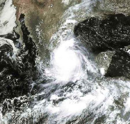
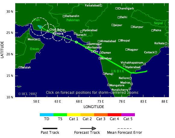
Dit jaar nog een tropical storm die onstond aan de oostkant van india en vervolgens aan de westkant in de Arabische zee tercht kwam (als tropical storm)
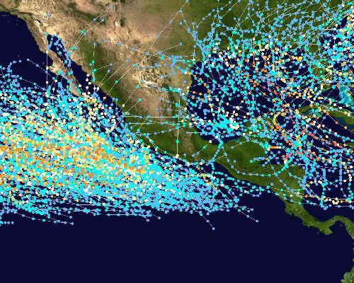
Hier een grote kaart met routes van orkanen over de gehele wereld.
[ Bericht 2% gewijzigd door #ANONIEM op 22-08-2007 23:20:01 ]
[ Bericht 2% gewijzigd door #ANONIEM op 22-08-2007 23:20:01 ]
Op weerwoord gevraagd, over een oversteek. Cesar in 1996 werd op de Pacific Douglas. Nu zou als de structuur intact blijft, dezelfde naam gehanteerd worden.
(Met dank aan H. Lankamp).
(Met dank aan H. Lankamp).
Ik HAAT mijn toetsenbord.
Dean is history.quote:Op vrijdag 24 augustus 2007 15:21 schreef Eveli het volgende:
Dean is nou toch geen orkaan meer, maar een tropische storm?
/ ¦ ¦ / ¦ ¦
TROPICS QUIET NOW BUT THAT WILL CHANGE SOON
There are still no named storms anywhere on the planet and while this is remarkable, it will not last long. The bursts of activity come in just that- bursts. 2005 was an exceptional year where every few days we had a new named storm. That won't happen again this year (it better not) but we are about to ramp things back up again. The tropical waves over Africa are getting vigorous with deeper convection associated with them. Most long range models show more development off of Africa within a week. We will also have to look closer to the west Atlantic in the coming days as well as this time of year so-called "home grown" development can take place. Have no fear- the tropics are very quiet today and will remain so this weekend. I think we might squeek out another 5 to 7 days without any real problems brewing, but after that period, things should be quite busy once again.
=================
(bericht van 25-8 op Hurricanetrack)

misschien ontwikkelt dit tot een tropische storm eind deze week.
verder kan er ook iets ontstaan bij de Afrikaanse kust eind deze week.
Dostojewski: "Je kunt je niet van je eigen gezond verstand overtuigen door je buurman op te sluiten."
quote:Op dinsdag 28 augustus 2007 22:06 schreef HurricaneTown het volgende:
10W is zonet ontstaan in de West Pacific.
Meer nieuws op plaatjes dadelijk !

A tropical depression has formed a little over 300 miles west of Manzanillo, Mexico, in the eastern Pacific. The depression could reach tropical storm strength later today as it moves toward the WNW. If it does, it would be named Gil. The westward motion of the system should keep it from threatening Mexico, however.
In the Atlantic, there are two areas being monitored for tropical development.
An area of low pressure a couple of hundred miles southeast of the Carolina coast is producing showers and storms over the Gulf Stream. Upper level conditions currently are not favorable for further development, but the low is expected to linger off the coast for the several days and drift southward, allowing conditions to become more conducive. Air Force Reserve Hurricane Hunters are scheduled to investigate the system tomorrow.
Meanwhile, a low pressure center about halfway between the Windward Islands and west Africa is moving westward into an area more favorable for development, and could become a tropical depression within the next day or so.
Back in the eastern Pacific, an area of thunderstorms south-southwest of the Gulf of Tehuantepec is moving into an area more conducive for development, and will be closely monitored.
The weather Channel


redelijk druk ja!
Dostojewski: "Je kunt je niet van je eigen gezond verstand overtuigen door je buurman op te sluiten."

tropische storm of hurricane Felix voor de ABC-eilanden?
en Japan zal Fitow wel goed in de gaten houden al.

Dostojewski: "Je kunt je niet van je eigen gezond verstand overtuigen door je buurman op te sluiten."
THE GOVERNMENT OF BARBADOS HAS ISSUED ATROPICAL STORM WARNING FOR THE ISLANDS OF ST. VINCENT AND THEGRENADINES. A TROPICAL STORM WARNING MEANS THAT TROPICAL STORMCONDITIONS ARE EXPECTED WITHIN THE WARNING AREA WITHIN THE NEXT 24HOURS.
/ ¦ ¦ / ¦ ¦
AT 5 PM AST...THE GOVERNMENT OF THE NETHERLANDS ANTILLES AND ARUBA
HAS ISSUED A TROPICAL STORM WATCH FOR THE ISLANDS OF
ARUBA...BONAIRE AND CURACAO. A TROPICAL STORM WATCH MEANS THAT
TROPICAL STORM CONDITIONS ARE POSSIBLE WITHIN THE WATCH
AREA...GENERALLY WITHIN 36 HOURS.
HAS ISSUED A TROPICAL STORM WATCH FOR THE ISLANDS OF
ARUBA...BONAIRE AND CURACAO. A TROPICAL STORM WATCH MEANS THAT
TROPICAL STORM CONDITIONS ARE POSSIBLE WITHIN THE WATCH
AREA...GENERALLY WITHIN 36 HOURS.
Dostojewski: "Je kunt je niet van je eigen gezond verstand overtuigen door je buurman op te sluiten."