WKN Weer, Klimaat en Natuurrampen
Lees alles over het onstuimige weer op onze planeet, volg orkanen en tornado's, zie hoe vulkanen uitbarsten en hoe Moeder Aarde beeft bij een aardbeving. Alles over de verwoestende kracht van onze planeet en tal van andere natuurverschijnselen.


Dean wordt telkens weer wat zuidelijker voorspeld.
hij gaat iig over de Bovenwindse Eilanden nu en daarna over Hispaniola en Cuba of Jamaica.
daarna kan ie nog altijd in Mexico of Amerika aan land komen.
of hij gaat nog verder zuidelijker vlak boven de ABC-eilanden zo naar Honduras/Belize/Yucatan.
hij gaat iig over de Bovenwindse Eilanden nu en daarna over Hispaniola en Cuba of Jamaica.
daarna kan ie nog altijd in Mexico of Amerika aan land komen.
of hij gaat nog verder zuidelijker vlak boven de ABC-eilanden zo naar Honduras/Belize/Yucatan.
Dostojewski: "Je kunt je niet van je eigen gezond verstand overtuigen door je buurman op te sluiten."
Sepat update: Momenteel uitgegroeid tot een categorie 4 typhoon, voorspelling is dat deze over 24 uitgroeid tot een Supertyphoon, een categorie 5!!!!!!!! Max windsnelheid verwacht van 145 knots....
Er is een grote kans dat het zuiden van Taiwan wordt geraakt, waar het nu al last heeft van veel regen en overstromingen. Met deze storm erbij voorspelt het weinig goeds. Taipei lijkt voorlopig veilig te zijn, maar stormen hebben de vervelende eigenschap de voorspellingen niet altijd te volgen.
prachtige oog te zien
Er is een grote kans dat het zuiden van Taiwan wordt geraakt, waar het nu al last heeft van veel regen en overstromingen. Met deze storm erbij voorspelt het weinig goeds. Taipei lijkt voorlopig veilig te zijn, maar stormen hebben de vervelende eigenschap de voorspellingen niet altijd te volgen.


prachtige oog te zien

Totaal Travel 04-24: 87 reizen, 151 vliegtickets, 58 landen, 6 continenten, 949 reisdagen, 163.804 foto's
Mijn reisfotos!
Mijn reisfotos!
Dean is stronger now and has slowed down some since the last advisory. This is important as it needs to consolidate before it can strengthen and by slowing down, it can begin to align itself in the atmosphere- like a cake in an oven. The cake cannot rise if it is bumped or moved. Same thing with a developing hurricane- the air must rise or convect in an even manner to allow pressures to fall and the process to continue feeding back on itself. I think we are starting to see that process begin with Dean and thus the NHC has bumped it up to 50 mph. Dean is likely to be a hurricane within a few days and the fear is that it could be quite strong at some point. When it begins to really crank is the big question. The forecast takes Dean right through the Lesser Antilles and certain islands could be impacted significantly by Dean. I really hope it does not get too strong before passing through the eastern Caribbean. After that point, Dean could just blast its way across the Caribbean, getting stronger along the way. Long range models show and have shown a huge array of possible threats and it is not prudent to dwell on any of them right now. Any impacts beyond the eastern Caribbean will be more than five days away- so there is plenty of time to monitor how things evolve
Wordt een flinke die Dean
[ Bericht 43% gewijzigd door Frutsel op 15-08-2007 08:39:07 ]

Wordt een flinke die Dean
[ Bericht 43% gewijzigd door Frutsel op 15-08-2007 08:39:07 ]
Flossie
Dit is wel vet zeg Een video van Flossie vanuit de ruimte
http://www.cnn.com/video/(...)sot.flossie.space.ap
[ Bericht 17% gewijzigd door Frutsel op 15-08-2007 11:01:31 ]

Dit is wel vet zeg Een video van Flossie vanuit de ruimte
http://www.cnn.com/video/(...)sot.flossie.space.ap
[ Bericht 17% gewijzigd door Frutsel op 15-08-2007 11:01:31 ]
The NHC has begun issuing advisories for TROPICAL DEPRESSION FIVE
A TROPICAL STORM WATCH HAS BEEN ISSUED FORTHE TEXAS COAST FROM FREEPORT SOUTHWARD...AND THE GOVERNMENTOF MEXICO HAS ISSUED A TROPICAL STORM WATCH FOR THE NORTHEAST COASTOF MEXICO FROM RIO SAN FERNANDO NORTHWARD.
Echt spannend lijkt deze niet te gaan worden, overigens.
A TROPICAL STORM WATCH HAS BEEN ISSUED FORTHE TEXAS COAST FROM FREEPORT SOUTHWARD...AND THE GOVERNMENTOF MEXICO HAS ISSUED A TROPICAL STORM WATCH FOR THE NORTHEAST COASTOF MEXICO FROM RIO SAN FERNANDO NORTHWARD.
Echt spannend lijkt deze niet te gaan worden, overigens.
/ ¦ ¦ / ¦ ¦
Mensen, ik zit momenteel op Curacao een aangezien jullie er meer verstabd van hebben dan ik kunnen jullie me vast wel vertellen of het gevaarlijk gaat worden hier...
Signature
Max.
4
Regels
Max.
4
Regels
Vlucht nu het nog kan!quote:Op woensdag 15 augustus 2007 13:49 schreef Joosje112 het volgende:
Mensen, ik zit momenteel op Curacao een aangezien jullie er meer verstabd van hebben dan ik kunnen jullie me vast wel vertellen of het gevaarlijk gaat worden hier...
* I intend to live forever, so far so good! *
Sepat heeft om 18:00 UTC een gemiddelde windsnelheid van 155mph en gusts van 190mph, en mag zich daarom nu officieel een Supertyphoon noemen, een echte categorie 5. Volgens mij eerste van het seizoen.
Totaal Travel 04-24: 87 reizen, 151 vliegtickets, 58 landen, 6 continenten, 949 reisdagen, 163.804 foto's
Mijn reisfotos!
Mijn reisfotos!
hm, dat is dus een kreng om in de gaten te houden....quote:Op woensdag 15 augustus 2007 18:17 schreef ETA het volgende:
Sepat heeft om 18:00 UTC een gemiddelde windsnelheid van 155mph en gusts van 190mph, en mag zich daarom nu officieel een Supertyphoon noemen, een echte categorie 5. Volgens mij eerste van het seizoen.
[b]Op maandag 6 september 2010 00:28 schreef tong80 het volgende:[/b]
GVD Wat moet jij een trotse vader zijn :)
:P
GVD Wat moet jij een trotse vader zijn :)
:P

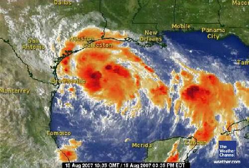
Tropical Storm ERIN... geen orkaan, maar gaat wel voor veel overlast zorgen.
quote:In the Gulf of Mexico, Tropical depression Five took shape last night, and has been upgraded to Tropical Storm Erin at 10 am CT moving northwest toward the southeastern Texas Coast.
Conditions appear favorable for Tropical Storm Erin to be a flooding rain threat into Friday night.
The current forecast track brings this system into the southern Texas Coast on Thursday, but the impacts will be felt along all of the Texas Coast, from Brownsville, through Corpus Christi and Houston, to Lake Charles, LA.
In fact, some showers and thunderstorms well out ahead of Erin, are already on the increase along the Texas Coast and will increase dramatically tonight into Thursday.
Through Thursday evening heavy showers and thunderstorms will bring heavy rainfall of 3 to 5 inches over South Texas, including areas from Brownsville to Corpus Christi, with as much as 2 to 4 inches from Houston to Lake Charles.
Gusty winds will also be on the increase, along with rough surf, especially along the southern Texas Coast. That being said, wind impacts will likely be far less compared to the heavy rain impact.
Meanwhile, our second area of concern, Tropical Storm Dean (60 mph), continues to move quickly west in the Atlantic.
Dean is forecast to become a hurricane by Thursday night or early Friday, and should be threatening the Lesser Antilles as early as Friday. From there, Dean should continue west-northwestward into the Caribbean.
It is too early to tell what, if any, impacts Dean will have on the United States.
Flossie has been downgraded to a tropical storm as of early this morning.
Strong shearing winds are blowing the thunderstorms northeast of the center of circulation and a continued weakening is expected through the day, as Flossie moves west-northwest.
Volgens onderstaande stukje merk je er weinig van op Curacaoquote:Op woensdag 15 augustus 2007 13:49 schreef Joosje112 het volgende:
Mensen, ik zit momenteel op Curacao een aangezien jullie er meer verstabd van hebben dan ik kunnen jullie me vast wel vertellen of het gevaarlijk gaat worden hier...
quote:Voor het zuidelijk gelegen Curacao is de kans (tot en met maandagnacht) dat het tot een orkaan komt, nihil (kleiner dan 0,5 %). De kans dat het tot stormkracht komt is ook al klein: 13%. Voor Sint-Maarten is die laatste waarde een stuk groter: 36%. De kans op orkaankracht is een stuk kleiner met 6%, maar gezien de potentieel verwoestende kracht van dergelijke winden is dit alles toch wel iets om in de gaten te houden. Bovendien vallen, ook als tropische stormen niet tot orkaankracht doorgroeien, er grote hoeveelheden regen.
weer.nl
Gonu was ook een Catogorie 5. In de Arabische Zee.quote:Op woensdag 15 augustus 2007 18:17 schreef ETA het volgende:
Sepat heeft om 18:00 UTC een gemiddelde windsnelheid van 155mph en gusts van 190mph, en mag zich daarom nu officieel een Supertyphoon noemen, een echte categorie 5. Volgens mij eerste van het seizoen.
TROPICS GETTING VERY ACTIVE NOW WITH OUR FIRST HURRICANE CLOSE AT HAND
Dus meer stormen mogelijk vlak na Dean, Erin...
(hurricanetrack)quote:I was just looking at a satellite loop of Dean and noticed how large it seems to have become tonight. Also, the outflow, or the air that is thrown out in a clock-wise fashion at the upper levels of the atmosphere, is impressive. Dean is poised to be a significant hurricane. People in the Lesser Antilles need to be preparing now for Dean and a hurricane watch has been posted accordingly. Let us hope that Dean does not get out of control before reaching the islands of the eastern Caribbean.
I still see the major global models keeping Dean on a southerly track through the Caribbean Sea. This would place Jamaica and the Yucatan very much in harm's way in less than a week. Dean is really moving fast and this will put it in the NW Caribbean sooner rather than later. As I check the latest GFS operational model run come in, it again insists that Dean will stay south of the United States and impact Mexico. Perhaps this will be the fate, perhaps not. Still too early to tell but we may have more clues tomorrow night and Friday as the NOAA G-IV jet is going to sample the environment ahead of Dean for better data input to the global models. So far, they have done pretty well once they stopped flip-flopping. Consistency is the key and the major models are fairly consistent right now.
Erin is about to come ashore in Texas and will be a big rain maker over the next several days. Be careful if you live in that area- pay attention to local information and media reports on flooding conditions, etc. We have to be smart here and not let a tropical storm cause loss of life. Erin should weaken quickly once inland later on Thursday but those rains will likely continue for a couple of more days.
Elsewhere, I see other disturbances about to make their way across the tropical Atlantic and indeed several computer models depict even more development soon. It is going to be quite a hurricane season and perhaps a stark contrast to last year. Be ready! I will have more info and updates here by mid-morning Thursday.
Dus meer stormen mogelijk vlak na Dean, Erin...
Dean upgraded to Hurricane
Hurricane Dean formed in the open Atlantic early Thursday and headed toward the Lesser Antilles in the Caribbean, forecasters said.
Hurricane warnings were issued for the islands of Dominica and St. Lucia by their local governments. Hurricane watches were in effect for the islands of Martinique and Guadeloupe and its dependencies, Saba and St. Eustaties.
At 5 a.m. EDT, Dean was centered about 485 miles east of Barbados and about 590 miles east of Martinique, according to the National Hurricane Center. It was moving west near 24 mph, and was expected to continue the same path for the next 24 hours.
Maximum sustained winds were near 75 mph, above the 74-mph threshold for a hurricane. Dean is a Category 1 hurricane and is expected to strengthen during the next 24 hours, forecasters said.
Out in the Gulf, Shell Oil Co. evacuated 188 people from offshore facilities in the path of Tropical Storm Erin.
A tropical storm warning was posted for the Texas coast from San Luis Pass, about 50 miles southwest of Houston, southward to the border. A tropical storm warning means that tropical storm conditions are expected within 24 hours. A tropical storm watch for northern Mexico was canceled.
Three to 8 inches of rain was possible along the middle Texas coast, the hurricane center said, with a storm surge of up to 3 feet above normal tide levels north of where the center makes landfall.
The U.S. Census Bureau said Wednesday that 4 million people could feel the storm's effects.
A series of storms this summer poured record rainfall across Texas and parts of Oklahoma and Kansas, with one July storm dropping 17 inches of rain in 24 hours. Flooding was widespread across all three states. It brought Texas out of drought status for the first time in more than a decade.
At least 16 deaths have been blamed on flooding since mid-June.
In the Pacific, Flossie was downgraded from a hurricane to a tropical storm after sideswiping Hawaii's Big Island with only intermittent rain and moderate winds.
It was a close call: Flossie approached the biggest and southernmost of the Hawaiian Islands with winds as high as 140 miles per hour earlier in the week, making it a Category 4 storm. If it had made landfall, the powerful hurricane would have been the first to hit the isles since Iniki slammed Kauai in 1992, killing six people.
"The storm that never was," said Karin Funai as she chatted with friends over coffee at the Pahala Town Cafe. "This was nothing."
Hurricane specialists expect this year's Atlantic hurricane season — June 1 to Nov. 30 _to be busier than average, with as many as 16 tropical storms, nine of them strengthening into hurricanes. Ten tropical storms developed in the Atlantic last year, but only two made landfall in the United States.
Tropical Storm Erin
CORPUS CHRISTI, Texas — Some vacationers packed up while others vowed to wait out Tropical Storm Erin and its torrential rainfall as it headed for flood-weary Texas early Thursday.
Erin was not expected to gain hurricane strength before making landfall Thursday morning, which was why some said they wouldn't abandon long-planned trips to the coast.
"It's not a hurricane. I ain't worried. If they say don't evacuate, I'm not going to worry about it," said Matt Sandlin of Amarillo, who was on a beach near Corpus Christi with his family on Wednesday as the wind whipped up and the horizon darkened with clouds. "Unless I see a shark or whale go flying by, I'm good."
Gov. Rick Perry ordered emergency vehicles and personnel, including National Guard troops, to the Harlingen and Corpus Christi areas.
"Because storms have saturated much of our state this summer, many communities in this storm's projected path are at high risk of dangerous flash flooding," Perry said in a statement.
Cameron County Judge Carlos Cascos, the top elected official for the state's southernmost county, urged residents to evacuate trailers and mobile homes on South Padre Island.
Corpus Christi hadn't asked for any evacuations, said Ted Nelson, a city spokesman, and was keeping only a handful of people at the emergency operations center overnight.
"We're just advising folks to review their own personal emergency plans and look around your yard and remove any loose items," he said.
Nelson said that with 3 1/2 months left in the Atlantic hurricane season, the incoming storm was "a nice little wake-up call" for people to make sure they are prepared for more severe weather.
Some weren't taking any chances.
"We came out to get as much beach time in as possible," said John Cullison of the Dallas area, who was vacationing with his family and planned to leave southern Texas Thursday instead of Friday. "After the hurricanes from a few years ago, you have to take it kind of serious."
Erin formed late Tuesday as the fifth depression of the Atlantic hurricane season and was upgraded to a tropical storm Wednesday when its maximum sustained speed hit 40 mph. The threshold for tropical storm status is 39 mph.
At 2 a.m. EDT, the storm was centered about 110 miles southeast of Corpus Christi and about 215 miles south-southwest of Galveston, according to the National Hurricane Center in Miami. Its top wind speed remained at 40 mph.
Erin was moving toward the west-northwest at around 12 mph and was expected to continue following that track for at least 24 hours. Its center was expected to be very near the Texas coast on Thursday morning, the hurricane center said.
Erin was likely too close to land to gain enough wind speed to become a hurricane, with sustained wind of at least 74 mph, said National Weather Service forecaster Tony Abbott in Brownsville. But the center said late Wednesday it could strengthen slightly before landfall.
Isolated tornadoes were possible along the middle Texas Gulf Coast on Thursday, the center said.
Hurricane Dean formed in the open Atlantic early Thursday and headed toward the Lesser Antilles in the Caribbean, forecasters said.
Hurricane warnings were issued for the islands of Dominica and St. Lucia by their local governments. Hurricane watches were in effect for the islands of Martinique and Guadeloupe and its dependencies, Saba and St. Eustaties.
At 5 a.m. EDT, Dean was centered about 485 miles east of Barbados and about 590 miles east of Martinique, according to the National Hurricane Center. It was moving west near 24 mph, and was expected to continue the same path for the next 24 hours.
Maximum sustained winds were near 75 mph, above the 74-mph threshold for a hurricane. Dean is a Category 1 hurricane and is expected to strengthen during the next 24 hours, forecasters said.
Out in the Gulf, Shell Oil Co. evacuated 188 people from offshore facilities in the path of Tropical Storm Erin.
A tropical storm warning was posted for the Texas coast from San Luis Pass, about 50 miles southwest of Houston, southward to the border. A tropical storm warning means that tropical storm conditions are expected within 24 hours. A tropical storm watch for northern Mexico was canceled.
Three to 8 inches of rain was possible along the middle Texas coast, the hurricane center said, with a storm surge of up to 3 feet above normal tide levels north of where the center makes landfall.
The U.S. Census Bureau said Wednesday that 4 million people could feel the storm's effects.
A series of storms this summer poured record rainfall across Texas and parts of Oklahoma and Kansas, with one July storm dropping 17 inches of rain in 24 hours. Flooding was widespread across all three states. It brought Texas out of drought status for the first time in more than a decade.
At least 16 deaths have been blamed on flooding since mid-June.
In the Pacific, Flossie was downgraded from a hurricane to a tropical storm after sideswiping Hawaii's Big Island with only intermittent rain and moderate winds.
It was a close call: Flossie approached the biggest and southernmost of the Hawaiian Islands with winds as high as 140 miles per hour earlier in the week, making it a Category 4 storm. If it had made landfall, the powerful hurricane would have been the first to hit the isles since Iniki slammed Kauai in 1992, killing six people.
"The storm that never was," said Karin Funai as she chatted with friends over coffee at the Pahala Town Cafe. "This was nothing."
Hurricane specialists expect this year's Atlantic hurricane season — June 1 to Nov. 30 _to be busier than average, with as many as 16 tropical storms, nine of them strengthening into hurricanes. Ten tropical storms developed in the Atlantic last year, but only two made landfall in the United States.

Tropical Storm Erin
CORPUS CHRISTI, Texas — Some vacationers packed up while others vowed to wait out Tropical Storm Erin and its torrential rainfall as it headed for flood-weary Texas early Thursday.
Erin was not expected to gain hurricane strength before making landfall Thursday morning, which was why some said they wouldn't abandon long-planned trips to the coast.
"It's not a hurricane. I ain't worried. If they say don't evacuate, I'm not going to worry about it," said Matt Sandlin of Amarillo, who was on a beach near Corpus Christi with his family on Wednesday as the wind whipped up and the horizon darkened with clouds. "Unless I see a shark or whale go flying by, I'm good."
Gov. Rick Perry ordered emergency vehicles and personnel, including National Guard troops, to the Harlingen and Corpus Christi areas.
"Because storms have saturated much of our state this summer, many communities in this storm's projected path are at high risk of dangerous flash flooding," Perry said in a statement.
Cameron County Judge Carlos Cascos, the top elected official for the state's southernmost county, urged residents to evacuate trailers and mobile homes on South Padre Island.
Corpus Christi hadn't asked for any evacuations, said Ted Nelson, a city spokesman, and was keeping only a handful of people at the emergency operations center overnight.
"We're just advising folks to review their own personal emergency plans and look around your yard and remove any loose items," he said.
Nelson said that with 3 1/2 months left in the Atlantic hurricane season, the incoming storm was "a nice little wake-up call" for people to make sure they are prepared for more severe weather.
Some weren't taking any chances.
"We came out to get as much beach time in as possible," said John Cullison of the Dallas area, who was vacationing with his family and planned to leave southern Texas Thursday instead of Friday. "After the hurricanes from a few years ago, you have to take it kind of serious."
Erin formed late Tuesday as the fifth depression of the Atlantic hurricane season and was upgraded to a tropical storm Wednesday when its maximum sustained speed hit 40 mph. The threshold for tropical storm status is 39 mph.
At 2 a.m. EDT, the storm was centered about 110 miles southeast of Corpus Christi and about 215 miles south-southwest of Galveston, according to the National Hurricane Center in Miami. Its top wind speed remained at 40 mph.
Erin was moving toward the west-northwest at around 12 mph and was expected to continue following that track for at least 24 hours. Its center was expected to be very near the Texas coast on Thursday morning, the hurricane center said.
Erin was likely too close to land to gain enough wind speed to become a hurricane, with sustained wind of at least 74 mph, said National Weather Service forecaster Tony Abbott in Brownsville. But the center said late Wednesday it could strengthen slightly before landfall.
Isolated tornadoes were possible along the middle Texas Gulf Coast on Thursday, the center said.


Dean wordt er ééntje om goed in de gaten te houden, het lijkt een actief seizoen te worden in tegenstelling tot vorig jaar.
* I intend to live forever, so far so good! *

Erin is inmiddels een tropische depressie.
Dean wordt sterker in de verwachtingen, met sustained winds van 115 KT (213km/h) en windstoten tot 140 KT (259km/h), wat Dean in de Cat. 4 brengt.
Dean wordt sterker in de verwachtingen, met sustained winds van 115 KT (213km/h) en windstoten tot 140 KT (259km/h), wat Dean in de Cat. 4 brengt.
/ ¦ ¦ / ¦ ¦
als dit uitkomt betekent dat een ramp voor kust Texas/Louisiana en al die olieinstallaties daar.
159 knots 295km/h
http://moe.met.fsu.edu/cgi-bin/gfdltc2.cgi?time=2007081612-dean04l&field=Sea+Level+Pressure&hour=Animation
hangt er dus vanaf of hij over Yucatan gaat of niet.
maar meer modellen gaat uit van noordwestelijke richting dan precies tussen Cuba en Yucatan zo naar Texas/Louisiana.

159 knots 295km/h
http://moe.met.fsu.edu/cgi-bin/gfdltc2.cgi?time=2007081612-dean04l&field=Sea+Level+Pressure&hour=Animation
hangt er dus vanaf of hij over Yucatan gaat of niet.
maar meer modellen gaat uit van noordwestelijke richting dan precies tussen Cuba en Yucatan zo naar Texas/Louisiana.
Dostojewski: "Je kunt je niet van je eigen gezond verstand overtuigen door je buurman op te sluiten."
Taiwan wordt hard getroffen. Als een categorie 4 gaat ie aan land bij Taiwan en vervolgens naar China.
Het zal me niets verbazen, als Hurricane DEAN ook nog een categorie 5 gaat worden.
Het zal me niets verbazen, als Hurricane DEAN ook nog een categorie 5 gaat worden.
Gisteravond werden we getroffen door een freak storm, je kan het witte plukje zien dat net voor de typhoon uitgaat. Forse regenbuien gepaard met ongelovelijk lange donderslagen. Een voorbode voor de big one Momenteel is het rustig en het zonnetje schijnt, maar over 24 ur gaat het spel beginnen, dan zal Sepat zo goed als zeker aan land komen...quote:Op donderdag 16 augustus 2007 13:58 schreef DrankBakje het volgende:
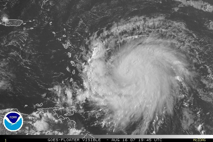
Sepat
[afbeelding]
Oog is mooi te zien
Zal behoorlijk tekeer gaan in taiwan denk ik.
Een directe hit op Taipei is onwaarschijnlijk, maar zal wel gebukt gaan onder troppische storm kracht winden. Op werk hebben ze inmiddels grote planken voor de ramen geplaatst. Als het mogelijk is zal ik morgen wel wat fotos maken, misschien dat ik nog wat interesante kiekjes kan maken
Inmiddels is Sepat afgezwakt en zal "maar" als een cat 4 aan land komen. Ik word toch lichtelijk nerveus nu ik de satelietbeelden zie, wat een gigantische monster is het:

update:
Meeste tracking sites hebben de verwachte pad van Sepat naar het noorden verschoven. Japanse weerbureau voorspelt dat Taipei toch nog dik in de gevarenzone zit..... Had ik eigenlijk niet echt meer verwacht. Ik denk dat ik toch echt serieuze voorbereidingen moet treffen. Collegas hebben het er ook al over voorbereidingen, en zij hebben toch wel meeste ervaringen met dit soort dingen....

Update 2
Here we go, grote golf grijze wolken drijft nu binnen.....

[ Bericht 15% gewijzigd door ETA op 17-08-2007 06:26:38 ]
Totaal Travel 04-24: 87 reizen, 151 vliegtickets, 58 landen, 6 continenten, 949 reisdagen, 163.804 foto's
Mijn reisfotos!
Mijn reisfotos!
Black swans matter

Zo, ik heb mijn fietstocht door de bergen van midden-Taiwan afgebroken en ben weer veilig terug in Taipei. Hier gebeurt normaal niks, maar in de bergen is het gevaarlijk door aardverschuivingen e.d.
"If you want to make God laugh, tell him about your plans"
Mijn reisverslagen
Mijn reisverslagen
Ben je net op tijd terug Selang Ik hoop dat je beetje hebt genoten van je rit
Taipei Times schrijft:
Taipei Times schrijft:
quote:Weather bureau issues alert for Typhoon Sepat
BATTEN THE HATCHES: If it holds its course, the powerful typhoon could affect the country early today and make landfall in the southeast tonight
STAFF WRITER, WITH CNA
Friday, Aug 17, 2007, Page 1
The Central Weather Bureau followed up its sea warning for Typhoon Sepat yesterday morning with a land warning at 8:30pm last night as the storm continued to approach.
At 8pm, the typhoon was centered 640km southeast of Taitung and was moving northwesterly at 20kph, packing maximum sustained winds of 191kph.
Forecasters said Sepat posed a threat to shipping southeast of Taiwan and in the Bashi Channel.
Lu Kuo-chen (呂國臣), a section chief at the Weather Forecast Center, said the eye of Sepat was clearly visible on satellite pictures, which indicated that it could be very destructive. With a radius of 250km, Sepat covers an area of 196,250km2 -- greater than the area of Taiwan, he said.
If Sepat stays on its current course, the fringe of the typhoon could affect the island early today and possibly make landfall over southeastern Taiwan tonight, the bureau said.
Airlines have canceled some flights and they urged passengers to confirm their flights well ahead of the scheduled departures.
All Uni Air flights to Taitung from Taipei after noon today have been canceled, as has the 8:40pm Kaohsiung to Taipei Uni Air flight, the company said.
All Far Eastern Air Transport flights after noon today have been canceled, the company said.
TransAsia Airways has canceled its afternoon flights to Hualien and Pingtung, as well as its flights to Kaohsiung and Tainan after 6pm, while Mandarin Airlines has canceled its flights to Kaohsiung, Hualien and Makung City today.
This story has been viewed 1141 times.
Totaal Travel 04-24: 87 reizen, 151 vliegtickets, 58 landen, 6 continenten, 949 reisdagen, 163.804 foto's
Mijn reisfotos!
Mijn reisfotos!
ETA, heb je ook foto's gemaakt van die binnendrijvende wolken/lucht?
Ben ik wel benieuwd naar hoe dat zoal gaat daar nu
Sterkte vast.. en zorg dat je d'r veilig doorheen komt
Ben ik wel benieuwd naar hoe dat zoal gaat daar nu
Sterkte vast.. en zorg dat je d'r veilig doorheen komt
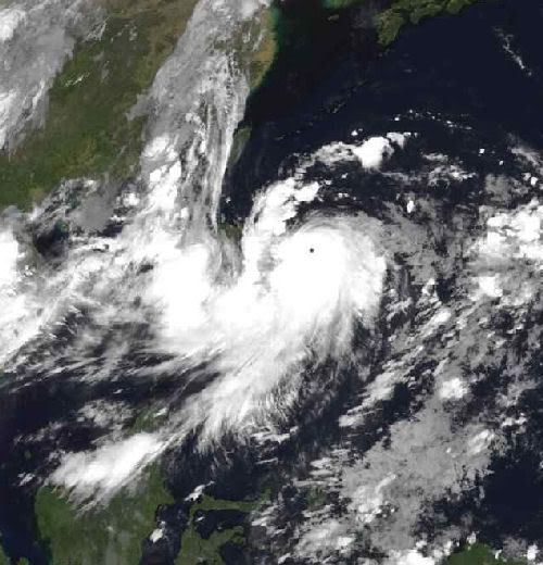
Dean struggling to maintain strength
Hurricane Dean has is being maintained as a weak category 2 hurricane with winds of 100 mph and a central pressure of 976 mb, but this may be generous. Judging by satellite imagery, Dean has been weakening and is looking much more ragged than he did this morning. While there is strong outflow in all quadrants, the circulation itself does not look to healthy.
Infrared image of Dean
Not only is Dean's general circulation looking much more ragged, but his eye has also completely disappeared. Despite my utmost effort, I was unable to locate a significant eyewall signature in any of the infrared, water vapor, or microwave imagery. There appears to only be a central dense overcast area.
Why exactly Dean is having so much trouble seems to be the question of the hour. The most obvious culprit that I can come up with is the broad area of dry air to the northwest of Dean.
Water vapor of Dean - Darker blue areas represent dry air
Like a '49er looking for gold, Hurricane Dean is moving westward at a very rapid clip, topping 25 mph at last report. This should enable Dean to get out of the fairly dry air it's in now and move into the Caribbean quickly where factors are more favorable for strengthening. Despite the dry air, it seems as if Dean isn't going to be held down for long. The computer models are quite clear expecting Dean to strengthen. While not all models can properly resolve Dean's intensity due to limited spatial resolution, they nearly all capture the strengthening trend that we expect.
Hurricane Dean has is being maintained as a weak category 2 hurricane with winds of 100 mph and a central pressure of 976 mb, but this may be generous. Judging by satellite imagery, Dean has been weakening and is looking much more ragged than he did this morning. While there is strong outflow in all quadrants, the circulation itself does not look to healthy.

Infrared image of Dean
Not only is Dean's general circulation looking much more ragged, but his eye has also completely disappeared. Despite my utmost effort, I was unable to locate a significant eyewall signature in any of the infrared, water vapor, or microwave imagery. There appears to only be a central dense overcast area.
Why exactly Dean is having so much trouble seems to be the question of the hour. The most obvious culprit that I can come up with is the broad area of dry air to the northwest of Dean.

Water vapor of Dean - Darker blue areas represent dry air
Like a '49er looking for gold, Hurricane Dean is moving westward at a very rapid clip, topping 25 mph at last report. This should enable Dean to get out of the fairly dry air it's in now and move into the Caribbean quickly where factors are more favorable for strengthening. Despite the dry air, it seems as if Dean isn't going to be held down for long. The computer models are quite clear expecting Dean to strengthen. While not all models can properly resolve Dean's intensity due to limited spatial resolution, they nearly all capture the strengthening trend that we expect.
4 Doden door tropische storm in Texas
De tropische storm Erin heeft in de staat Texas vier levens geëist. Het natuurgeweld heeft ook een enorme ravage aangericht.
Houston
In Houston, de grootste stad van Texas, zijn door zware regen overstromingen ontstaan. Erin kwam aan land met een snelheid van 280 kilometer per uur en ging landinwaarts met grote rukwinden.
Zware regenval
Door de zware regenval stortte het dak van een winkel in Houston in. Daarbij kwam een persoon om het leven. Drie anderen overleden bij verkeersongelukken.
============
wacht ff... 280 km/u ?
dat lijkt me toch verdomd sterk? dan was het een cat.5 geweest?
Black swans matter
Ik kwam vanmorgen met de bus vanaf Taichung en toen zag je mooi dat de westkant blauwe lucht was en aan de oostkant allemaal hele mooie wolken. Maar het is dus niet zo dat je een massieve muur van wolken op je af ziet komen ofzo. Het gaat heel geleidelijk.quote:Op vrijdag 17 augustus 2007 08:06 schreef Frutsel het volgende:
ETA, heb je ook foto's gemaakt van die binnendrijvende wolken/lucht?
Vaak is het de dag voordat de typhoon komt juist heel mooi weer met een blauwe lucht en een ontzettend felle zon. Het is net alsof de naderende typhoon het vocht uit de lucht wegtrekt ofzo waardoor je zo'n felle zon krijgt. Gisteren was dat dus ook zo. Ben flink verbrand
Verder is zo'n typhoon meestal niet echt spectaculair. Het is gewoon 1 of 2 dagen kutweer met vooral heel veel regen. Er zijn korte periodes met hele sterke wind. De meeste schade wordt veroorzaakt door instortende berghellingen die wegspoelen door de grote hoeveelheid water. Maar in een stad als Taipei gebeurt er meestal weinig. We hadden wel in 2004 of 2005 een keer binnen 48 uur 1300mm regen in Taipei.
"If you want to make God laugh, tell him about your plans"
Mijn reisverslagen
Mijn reisverslagen
Hey Selang, als ik nu naar buiten kijk, betekend dat de typhoon is aangekomen? Het was plotseling donker buiten en zie geen hol meer door de regen......... kut, had mn camera moeten meenemen vandaag
Totaal Travel 04-24: 87 reizen, 151 vliegtickets, 58 landen, 6 continenten, 949 reisdagen, 163.804 foto's
Mijn reisfotos!
Mijn reisfotos!
Idd. Die 280 km/u slaan nergens op. Anders hadden wij het hier toch echt wel geweten dacht ik zoquote:Op vrijdag 17 augustus 2007 08:28 schreef Frutsel het volgende:
4 Doden door tropische storm in Texas
De tropische storm Erin heeft in de staat Texas vier levens geëist. Het natuurgeweld heeft ook een enorme ravage aangericht.
Houston
In Houston, de grootste stad van Texas, zijn door zware regen overstromingen ontstaan. Erin kwam aan land met een snelheid van 280 kilometer per uur en ging landinwaarts met grote rukwinden.
Zware regenval
Door de zware regenval stortte het dak van een winkel in Houston in. Daarbij kwam een persoon om het leven. Drie anderen overleden bij verkeersongelukken.
============
wacht ff... 280 km/u ?
dat lijkt me toch verdomd sterk? dan was het een cat.5 geweest?
Black swans matter
Ja dat is em.quote:Op vrijdag 17 augustus 2007 10:54 schreef ETA het volgende:
Hey Selang, als ik nu naar buiten kijk, betekend dat de typhoon is aangekomen? Het was plotseling donker buiten en zie geen hol meer door de regen......... kut, had mn camera moeten meenemen vandaag
Ik was net ff buiten ff wat eten, windstil en geen regen. Een kwartiertje later loop ik terug en toen kwam het met bakken uit de hemel. Nu is het weer even rustig. Maar de echt harde wind komt pas als je dichter bij het oog zit (vannacht waarschijnlijk).
"If you want to make God laugh, tell him about your plans"
Mijn reisverslagen
Mijn reisverslagen
Ik zit in Sijhih/Hsichih/XiZhi (romanization ),Taipei county. Tweede "golf" lijkt nu over te trekken, het is weer pikkedonker. Inmiddels waarschuwingberichten over de bedrijfsspeakers, volgens mij is het advies om naar huis te gaan (ik versta nauwelijks chinees ), maar niemand reageert.... anyway, ik ga over 20 minuten ook maar naar huis om nog ff snel wat inkopen te doen. Hopelijk kan ik een taxi pakken, maar dat zit er waarschijnlijk niet in met dit weer....
Overigens hoorde ik wel net dat paar jaar geleden het gebied waar ik nu zit zwaar was overstroomd na een typhoon. Niet erg prettig om te horen aangezien ik op de begane grond woon
Volgens mij staat hier: http://www.cpa.gov.tw/ dat alle scholen en bedrijven dicht gaan vanavond in en rondom taipei.
taipei heeft momenteel het zwaarst qua regen:

Totaal Travel 04-24: 87 reizen, 151 vliegtickets, 58 landen, 6 continenten, 949 reisdagen, 163.804 foto's
Mijn reisfotos!
Mijn reisfotos!
Black swans matter
Ja balen dat het in het weekend is, anders had je een typhoon holidayquote:Op vrijdag 17 augustus 2007 11:41 schreef ETA het volgende:
Volgens mij staat hier: http://www.cpa.gov.tw/ dat alle scholen en bedrijven dicht gaan vanavond in en rondom taipei.
Vorig jaar hadden we niet één typhoon holiday, maar het jaar ervoor 3 of 4
"If you want to make God laugh, tell him about your plans"
Mijn reisverslagen
Mijn reisverslagen
hee orkaan dean komt toch niet dichtbij curacao want daar ga ik maandag heen op vakantie?
Word nu wel bang daarvoor.
Word nu wel bang daarvoor.
Dean zal daar niet echt komen.. daar hoef je je niet druk om te maken. Hooguit wat regen nog.. op maandag want hij komt morgen in dat gebied. Hoe lang blijf je daar op vakantie?quote:Op vrijdag 17 augustus 2007 12:13 schreef sangirl25 het volgende:
hee orkaan dean komt toch niet dichtbij curacao want daar ga ik maandag heen op vakantie?
Word nu wel bang daarvoor.
not at all, 0,5% kans daarop.quote:Op vrijdag 17 augustus 2007 12:13 schreef sangirl25 het volgende:
hee orkaan dean komt toch niet dichtbij curacao want daar ga ik maandag heen op vakantie?
Word nu wel bang daarvoor.
Passion for Christ
Sorry hoor, maar als jij NU geen camera bij je hebt ben je toch echt wel een enorme paardenlul.quote:Op vrijdag 17 augustus 2007 10:54 schreef ETA het volgende:
Hey Selang, als ik nu naar buiten kijk, betekend dat de typhoon is aangekomen? Het was plotseling donker buiten en zie geen hol meer door de regen......... kut, had mn camera moeten meenemen vandaag
het is ondertussen al avond en donker buiten, dus veel zie je niet misschien dat ik morgenochten wel ff op pad ga, maar verwacht eigenlijk niet veel spectaculairs nu de typhoon richting het zuiden is gegaan,quote:Op vrijdag 17 augustus 2007 15:12 schreef Gallard het volgende:
[..]
Sorry hoor, maar als jij NU geen camera bij je hebt ben je toch echt wel een enorme paardenlul.
Totaal Travel 04-24: 87 reizen, 151 vliegtickets, 58 landen, 6 continenten, 949 reisdagen, 163.804 foto's
Mijn reisfotos!
Mijn reisfotos!
Dean wordt toch erg sterk, de verwachtingen gaan richting 130 KT, >136KT is cat 5. 130 KT = 241km/h en de winstoten gaan tot 160 KT, 296km/h. Poor Yucatan...
/ ¦ ¦ / ¦ ¦
holy shit...quote:Op vrijdag 17 augustus 2007 17:05 schreef highway101 het volgende:
Dean wordt toch erg sterk, de verwachtingen gaan richting 130 KT, >136KT is cat 5. 130 KT = 241km/h en de winstoten gaan tot 160 KT, 296km/h. Poor Yucatan...
* I intend to live forever, so far so good! *
nou poor Yucatan...
lijkt dat hij precies door de Straat Yucatán heen gaat en dan zo richting Galveston/Houston.
al die olieplatformen en raffinaderijen stuk.
en door Erin is daar al enorm veel regen gevallen dus grond is compleet verzadigd.
NHC wil hier nog niet voor gaan waarschuwen om geen paniek te veroorzaken.
lijkt dat hij precies door de Straat Yucatán heen gaat en dan zo richting Galveston/Houston.
al die olieplatformen en raffinaderijen stuk.
en door Erin is daar al enorm veel regen gevallen dus grond is compleet verzadigd.
NHC wil hier nog niet voor gaan waarschuwen om geen paniek te veroorzaken.


Dostojewski: "Je kunt je niet van je eigen gezond verstand overtuigen door je buurman op te sluiten."
...DEAN STRENGTHENS TO A MAJOR HURRICANE WITH 125 MPH WINDS...
categorie 3 nu.
vanaf 131 mph is het een categorie 4.
categorie 3 nu.
vanaf 131 mph is het een categorie 4.
Dostojewski: "Je kunt je niet van je eigen gezond verstand overtuigen door je buurman op te sluiten."

quote:Op vrijdag 17 augustus 2007 20:10 schreef Caesu het volgende:
...DEAN STRENGTHENS TO A MAJOR HURRICANE WITH 125 MPH WINDS...
categorie 3 nu.
vanaf 131 mph is het een categorie 4.
klopt toch helemaal niks van.quote:***************************************
Doden in Texas door tropische storm
***************************************
` Door de tropische storm Erin zijn in
de Amerikaanse staat Texas zeven mensen
omgekomen.Er zijn 3 vermisten.De storm
kwam aan land met een snelheid van 280
km per uur en gaat gepaard met zware
regenval.Houston en San Antonio staan
voor een deel onder water.
De eerste orkaan van het seizoen,Dean,
wint in het Caribisch gebied steeds
meer aan kracht.Hij is nu ingeschaald
in 3,de op twee na zwaarste categorie.
Dean is over St.Lucia en Martinique
getrokken,waarbij één dode is gemeld.Nu
bereidt Jamaica zich voor op de komst
van Dean.Op het Mexicaanse eiland
Yucatan kan Dean nog krachtiger worden.
***************************************
kwam met windsnelheid 65km/h uur aan land.
Dostojewski: "Je kunt je niet van je eigen gezond verstand overtuigen door je buurman op te sluiten."
Mogelijk wordt Dean een zware Catogorie 5. Volgens sommige berekeningen zouden er windvlagen van 330km per uur kunnen gaan komen. Op dit moment is Dean een Catogorie 3.
Over slachtoffers in Taiwan door de Typhoon Sepat is nog niets bekend. Sepat is als een Catogorie 3 aan land gegaan. Achter Sepat lijkt zich een nieuwe storm te ontwikkelen.
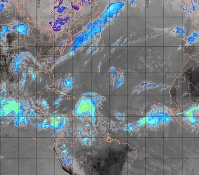
Ook in de Atlantische Oceaan is weer een redelijk actief gebied ontstaan. Misschien dat daar ook weer een storm uit ontstaan.
Dit is ook het geval in de E.Pacific.
[Update]
Er is zonet de 1st dode gemeld door Dean.
Op St. Lucia is een man de rivier in geblazen en verdronk toen hij een koe wilde redden.
Over slachtoffers in Taiwan door de Typhoon Sepat is nog niets bekend. Sepat is als een Catogorie 3 aan land gegaan. Achter Sepat lijkt zich een nieuwe storm te ontwikkelen.
Ook in de Atlantische Oceaan is weer een redelijk actief gebied ontstaan. Misschien dat daar ook weer een storm uit ontstaan.
Dit is ook het geval in de E.Pacific.
[Update]
Er is zonet de 1st dode gemeld door Dean.
Op St. Lucia is een man de rivier in geblazen en verdronk toen hij een koe wilde redden.
Hij trekt volgens de laatste berichten precies over Jamaica heen. Dat zal binnen 2 dagen gaan
gebeuren. Als een categorie 4
gebeuren. Als een categorie 4